Download
1 / 30
301 likes | 472 Vues
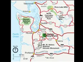
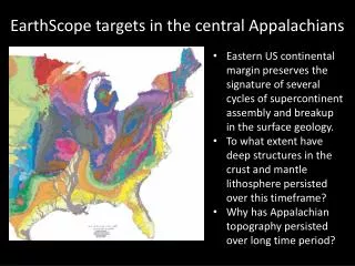
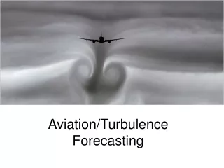
Unique Meteorological Characteristics of the Central Appalachians and their Implications on Aviation Forecasting. Kevin Lipton and Aaron Tyburski Forecasters, State College PA. Central Appalachians - Topography. Source: U.S. Geological Survey. Common Meteorological Phenomena….

E N D
Unique Meteorological Characteristics of the Central Appalachians and their Implications on Aviation Forecasting Kevin Lipton and Aaron Tyburski Forecasters, State College PA
Central Appalachians - Topography Source: U.S. Geological Survey
Common Meteorological Phenomena… • Cold Air Damming • Low Level Wind Shear • Persistent Low Ceilings/Visibilities • Precip.-Type Problems • Thunderstorm Forecasting • Orographic Effects (mainly Plateau Regions) • Upslope/Downslope effects on clouds • Precip./Lake Effect Events
Common Meteorological Phenomena… • Topographical • Fog formation/dissipation • Convective Initiation • Mesoscale Wind Circulations • Other… • Haze Layers
Cold Air Damming • Cold air remains trapped at low levels, while warmer air moves in aloft, above the cold low-level layer. • Most prevalent between the Coastal Plain and the Appalachian Plateau region. • Has many effects on sensible weather, and thus on aviation!
Factors that favor cold air damming (from HPC)… • A cold surface high passes north of the Mid Atlantic States and New England. • Cold air supplied by the surface high is channeled southward along the east slopes of the Appalachians. • A ridge of high pressure develops between the mountains and the ocean. This helps to maintain a northerly component to the low level winds over the land. • Easterly or northeasterly low level winds over the ocean and the more northerly winds over the land tighten the thermal gradient near the coast. • When shallow arctic air is present, the computer models often have a hard time holding onto cold-enough low level temps when the surface high is still over New England or the Great Lakes regions.
Conceptual Dynamical Model of Cold Air Damming Diagram from UCAR/Comet Course “Cold-Air Damming”
Effects of Cold Air Damming…and on Aviation… • Low Level Wind Shear – as NE or N winds remain within Boundary Layer, then rapid increase in wind speeds, along with strongly veering direction with height above inversion. • Terminals within valley locations, immediately adjacent to a ridge are particularly at risk. (Example: Williamsport, PA – KIPT)
Example of CAD Cross Section… Diagram from UCAR/Comet Course “Cold-Air Damming”
Effects of Cold Air Damming…and on Aviation (cont’d)… • Low Clouds and Visibilities – extended IFR-VLIFR conditions. • Moisture remains trapped underneath inversion – creates extended periods of low clouds, drizzle, and fog. • Precip.-Type Problems (Cold-Season): • Freezing Rain/Sleet • Often affects ridge-tops the worst, as slight moist adiabatic profile creates coldest air just above the surface, such as 2000-3000 Ft. AGL, with warmer above-freezing air higher up, above the inversion layer.
Sounding Example within Cold-Air Damming… Diagram from UCAR/Comet Course “Cold-Air Damming”
Effects of Cold Air Damming…and on Aviation (cont’d)… • Thunderstorm Forecasting • Cool/stable low levels often weaken thunderstorms approaching from the west. • Weak surface lows occasionally develop on warm front near Mason-Dixon line as cool wedge begins to weaken/retreat. • Sometimes cause thunderstorms to ‘flare’ up again. • Increased low level shear near/just north of warm frontal boundary occasionally can aid in tornadogenesis, especially when coincident with low LCL’s.
Example of Orographic Effects… From Comet/UCAR “Hydrometeorology Course”
Orographic Effects • Upslope/Downslope Effects – can produce localized pockets of VFR conditions, embedded within broader area of MVFR/IFR conditions. • UPSLOPE Flow: • Appalachian Plateau Region – worst conditions with westerly, upslope flow. • Additional low level moisture added by Great Lakes. • Lake Effect Snow Squalls – can produce highly variable conditions over very small distances. • Appalachian Ridge/Valley Locales eastward – worst conditions with Easterly low level flow. • Added moisture from Atlantic Ocean.
Orographic Effects (cont’d) • DOWNSLOPE flow • Appalachian Plateau Region – easterly wind component. • Often KLBE (Latrobe, PA) will be VFR, while KJST (Johnstown, PA) will remain locked in LIFR conditions. • Appalachian Piedmont – westerly wind component.
Topographic Effects • Radiation Fog • Particularly Prevalent within Ridge/Valley section of Appalachian, although occurs elsewhere. • Within deeper valley locations, especially in the fall, dense fog could prevail well into the midday hours, especially when adjacent to a river. • Forecasting Challenge: When Fog will lift, and low clouds will dissipate.
Topographic Effects (cont’d) From UCAR ATOC 5600, Physics and Chemistry of Clouds and Aerosols, “Interactions between Aerosols and Fogs”
Topographic Effects (cont’d) • Convective Initiation • Generally favored across higher terrain (where parcels reach LFC faster). • Often develops within Plateau region first, then shifts toward the Ridge/Valley areas, and finally Piedmont areas. • Forecasting Challenges: • When will convection develop? • Will convection strengthen, weaken, or maintain its intensity as it tracks toward the Piedmont?
Topographic Effects (cont’d) • Mesoscale wind circulations • Thermally-induced, with uneven heating between adjacent ridges, and valley floors. • Have a diurnal nature. • More prevalent within steeper terrain – especially Rockies, and southern Appalachians. • Generally comprised of slope and valley winds.
Examples of Valley Winds From COMET/UCAR Module “Thermally-Forced Circulations II – Mountain/ValleyBreezes”
Diurnal Variation of Valley Winds From COMET/UCAR Module “Thermally-Forced Circulations II – Mountain/ValleyBreezes”
HAZE – Appalachians and many other areas across the eastern U.S… • Where does eastern haze come from? • Anthropogenic SO2 comes mainly from combustion of sulfur-bearing fossil fuels in power plants, oil refineries and steel mills. • Oxidation of SO2 creates sulfates (sulfate aerosols) – which are the main particles that comprise eastern haze. • Higher relative humidities increases the oxidation rate of SO2 into sulfates. • Sulfates are HYGROSCOPIC – in that they absorb water molecules from the environment, even when the relative humidity is below 100%.
Haze – cont’d • Where does eastern haze come from (cont’d)… • Sulfate aerosols grow as water vapor condenses on them. • Reach a size of .1 to 1, reaching a maximum in scattering efficiency per unit particle mass. • IT IS THIS SCATTERING (OF SUNLIGHT) BY THE SULFATE AEROSOLS THAT IS RESPONSIBLE FOR MOST OF THE “EASTERN HAZE.”
HAZE (Cont’d)… • Most of the anthropogenic sources of sulfur dioxide are located in the Ohio Valley, and southern Great Lakes. • Summer circulation frequently brings these sulfates around western periphery of ‘Bermuda High’, and thus across Appalachians!
Distribution of SO2 Emissions during summer in Eastern U.S. in metric tons/day
Long-Term Distribution of Haze…expressed as average visibility in km
Summary • There are numerous meteorological conditions to the Appalachian Region that produce unique challenges to Aviation Forecasters. • Understanding the local climatology of specific regions within the Appalachians can significantly enhance forecasting skills, which can also help aviation interests within the region.
References… • Corfidi, S. F., 1996: The Development and Movement of Warm Season Haze Over the Central and Eastern United States.Natl. Wea. Dig., 20:3, 2-14. • Whiteman, C.D., 2000: Mountain Meteorology: Fundamentals and Applications. Oxford University Press, 355 pp.