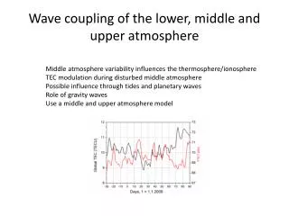
Download
1 / 52
730 likes | 3.55k Vues
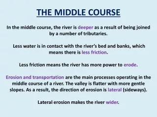
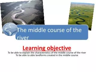
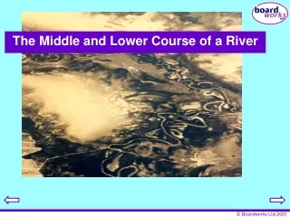
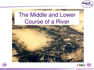
The Middle and Lower Course of a River. Starter: Draw a simple diagram of the river cross section at the following areas: Upper course Middle course Now draw on the direction of erosion (lateral or vertical). Fluvial Landforms: Depositional.

E N D
The Middle and Lower Course of a River • Starter: • Draw a simple diagram of the river cross section at the following areas: • Upper course • Middle course • Now draw on the direction of erosion (lateral or vertical).
Fluvial Landforms: Depositional Today we will study the main landforms formed by deposition. These landforms will tend to be found in the middle and lower course of a river. What do you think the relief be like in the lower course?
Discussion • How does the gradient of a river change along its course? • How does the balance between erosion and deposition change? • How does the size of material change along the profile? • What are the 4 processes of transportation?
How is material transported downstream? Traction Saltation Suspension Solution
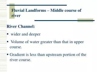
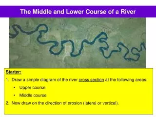
Middle course, R. Tees Valley opens out, more gentle slopes, wider valley bottom First signs of meanders Floodplain River channel wider, deeper, greater velocity and discharge
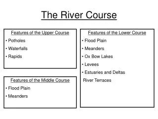
What landforms are found in the Middle Course of a River? • Braiding • Meanders • Oxbow Lakes
Braiding • Braiding occurs when a river is a river deposits all or some of its load when there is too much material to carry. • This is likely to happen when extra material is added into the river and/or when the river loses velocity. • Braiding occurs when the river splits into two or more channels due to the deposition. The ‘islands’ formed are called eyots. eyots
MEANDERS • A stream consisting of successive Meanders • A meander in general is a bend in a sinous watercourse.
Meanders • Meander bends occur in the middle section when the river has a shallower slope (gradient) so its power does not erode vertically, but laterally. • Simulations with laboratory models of rivers have shown that, above a critical minimum velocity, meanders will form. Friction with the channel bed and banks causes turbulence in the water flow, which promotes the development of alternating bars of sediment along the channel. • These bars of sediment are called riffles • Alternating with the riffles are pools of deeper water. • The riffles disrupt the water flowing over it, swinging the water towards the outer banks. • A meander starts to form at the deeper side of the river where it flows faster and has more power to erode sideways.
http://www.cleo.net.uk/consultants_resources/_files/meander4.swfhttp://www.cleo.net.uk/consultants_resources/_files/meander4.swf
FLOW IN MEANDERS • Once the meander starts to develop, helicoidal flow (corkscrew shaped flow) is established, with the water surface being elevated on the outer bank of each curve, and return currents at depth directing the flow towards the opposite bank. • The outer bank is eroded as a result of the higher flow velocity, whereas material is carried by the flow and deposition takes place on the inner bank, and forms a point bar. • It is the major flow in the meander bends.
Middle Course: Meanders Also known as the ‘Mature’ stage Meanders 1 (Aerial View) Meanders are formed because the current swings to the outside of a bend and concentrates the erosion there. Deposition occurs on the inside of the bed where there is not enough energy to carry load. EROSION TYPE: Lateral
Meander, R. Lavant, Chichester WHAT DO THE ARROWS POINT TO? WHICH WAY IS THIS MEANDER MOVING? Floodplain Slip-Off Slope River Cliff Point bar deposits on the inner meander bend where there is low energy
Meanders Constant erosion (undercutting) erodes the outer (concave) bank of the meander, forming a river cliff Constant deposition at the outer (convex) bank deposits sediments, forming a river slope
WHERE IS EROSION TAKING PLACE? Cut bank erosion (River Cliff) F A E B Point bar deposits } Meander loop C D WHERE IS DEPOSTION TAKING PLACE?
Formation Sequence Of OxBow Lakes Maximum deposition Maximum erosion
Final Stage Meander scars Oxbow Lake Oxbow cuttoff
Ox-bow Lake A U-shaped body of water formed when a wide meander from the main stem of a river is cut off to create a lake
Ox-bow Lake River constantly erodes the outer banks of two adjacent meanders causing the meanders to move closer together forming a loop Overtime, the loop becomes more distinct and is separated by a narrow neck of land
Ox-bow Lake River Landforms As erosion and deposition continue to take place along the inner and outer banks respectively, the two meanders eventually meet The sediments deposited will eventually dam up the water in the cut off, forming an ox-bow lake
Oxbow Lakes When the river floods it breaks through the thin meander neck and the river takes the easier, straight course. This leaves the meander loop ‘cut off’ as an oxbow lake. Over time, the oxbow lake will become colonised by vegetation. new course of the river Meander neck becomes smaller oxbow lake
Meander Bend on the River Conwy A B Explain why there is more deposition at ‘A’ rather than at ‘B’.
Sketch this plan view of a meander bend and label the line of highest velocity.
Draw the following four diagrams in the correct order of oxbow lake formation. Match 3 of the diagrams with the most appropriate explanation from ‘A’, ‘B’ and ‘C’. 2. 3. 4. X =erosion on the outside of the meander bend 1. X X X X X A. The river floods and erodes through the thin meander neck. The river now takes the easier, straight course. The meander loop is left as an oxbow lake. B. The river meanders. The fastest flow is therefore on the outside of the bend. This fast current erodes the meander neck through the processes of erosion. C. The meander neck is further eroded until only a thin piece of land separates the two channels.
Name the river landform shown in this aerial photograph. What else can you identify? How can you tell that this is not the Upper Course of a river?
This is a cross section of a meander bend. Sketch the diagram and mark on the following River Cliff Fastest velocity Slip off slope Undercutting Area of deposition
Questions • What is braiding? • Explain how a meander may form and then migrate along the course of a river across . Use the following words: • Riffles • Pools • Helicoidal flow • Point Bar • Cliff • Slip off Slope • Erosion • Deposition • Convex • Concave • Using a series of diagrams, explain the formation of ox-bow lakes.