Download
1 / 15
150 likes | 161 Vues
This document provides an overview of the COASTAL Act implementation efforts by NOAA and its interagency partners. It includes information on the background, implementation approach, data collection plan, and model and database. The focus of the COASTAL Act is to improve the determination of wind vs. water damage in cases of "indeterminate losses" caused by named tropical systems impacting the US and its territories.

E N D
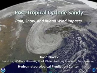
COASTAL Act Requirements for • Tropical Cyclone Post-Storm Assessments and • Response by NOAA and • Interagency Partners • March 7, 2013 • S. Lord (NWS/OST) • M. Bilder (NWS/OSPP) • M. Powell (OAR/AOML/HRD) • J. Feyen (NOS/OCS/CSDL/MMAP) • Westhuysen (NWS/NCEP/EMC) • T. Owen (NESDIS/NCDC)
Overview • Background • Implementation Approach • Data Collection Plan • Model and Database • Summary: General Challenges
BackgroundSummary Consumer Option for an Alternative System to Allocate Losses (COASTAL) Act signed 6 July 2012. Intended to lower costs to FEMA’s National Flood Insurance Program Focus: improve determination of wind vs. water damage in cases of “indeterminate losses” (or “slab cases”). NOAA required to produce Detailed “post-storm assessments” [analyses] Named tropical systems impacting U.S. and its territories Criteria Defined surface circulation Maximum winds of at least 39 miles per hour Named as Tropical Storm or Hurricane by National Hurricane Center
BackgroundNOAA Partners NOAA Team NWS Office of Science & Technology (OST, incl. Meteorological Develop Laboratory) National Centers of Environmental Prediction (incl. EMC and NHC) Office of Hydrological Development (OHD) Office of Climate, Weather & Water Services (OCWWS) Office of Strategic Planning and Policy NOS Office of Coast Survey Coastal Services Center Integrated Ocean Observing System Program Policy, Planning & Analysis Division OAR Atlantic Oceanographic & Meteorological Lab (Hurricane Research Division, HRD) NESDIS National Climatic Data Center (NCDC) National Geophysical Data Center (NGDC) Also consulting with NOAA OGC and OLIA on legal and congressional matters.
BackgroundPartnering - OFCM Joint Action Group for the COASTAL Act Post-Storm Analysis (JAG/CAPSA, est. Sept. 2012) Exec Secretary: Mike Bonadonna Co-chaired by NOAA (S. Lord) U.S. Army Corps of Engineers (A. Niles) USGS (R. Mason) Taking lead on drafting the data collection plan due to Congress in April 2013. NIST, USDA, NASA, and the Digital Hurricane Consortium have also participated in JAG/CAPSA as either members or technical advisors. Completed actions Mandated inventory of available observing systems and requirements (Oct. 2012) Identified (through RFI) all Federal, state, private and academic efforts and systems capable of collecting “covered data”, including private data suppliers (Jan. 2013)
BackgroundOther Partners • FEMA must develop the COASTAL Formula • A standard recipe to determine and allocate wind losses and flood losses for claims involving indeterminate losses • Developed in consultation with NOAA • NAS will evaluate the formula’s effectiveness • GAO must audit NOAA’s data collection efforts, including the cost-effectiveness of the approach • Community-based Subject Matter Experts
Implementation Approach • Focus NOAA Deliverables: • With OFCM and Interagency partners, complete and submit data collection plan (COASTAL Act Capabilities Development Plan or CACDP) • Draft under ICMSSR review • Due Apr. 2013 • Establish Coastal Wind and Water Event Database (CWWED, Jul. 2013) • Named Storm Event Model (NSEM, Dec. 2013) • Establish protocol for collecting covered data (Dec. 2013)
Data Collection Plan (CACDP) Contains Overview of the COASTAL Act implementation effort General descriptions of the methodologies behind data collection, the database, the model and the post-storm assessment process Compendium of observing systems and requirements (appendices) Details will be presented in NSEM and CWWED
Named Storm Event Model (NSEM) • Collection of separate, but interdependent, gridded products • Provide time-dependent analyses of specific meteorological, oceanographic and hydrodynamic factors contributing to indeterminate losses • Analysis and hindcast gridded products derived from observations • Products will cover 4 primary risk areas: • Wind and surface pressure (including embedded severe/ convection events) • Storm Surge/Waves • Precipitation (including impact on Riverine domain) • Riverine Flooding/Runoff • Input from highest resolution bathymetric and topographic data is essential • Validating accuracy (90% criterion from COASTAL Act) • Meeting accuracy requirements will be a major challenge • Bootstrapping technique is likely • Considers variability of and verification of analyses produced from independent sub-samples of total observations and ratios of variability to mean analyzed quantity (e.g. wind speed)
NSEM Software Candidates • Wind • H*Wind analysis • Real-Time Mesoscale Analysis (RTMA) • Hurricane WRF (HWRF) • Storm Surge/Waves • Advanced Circulation (ADCIRC) model • Nearshore Wave Prediction System (NWPS, Wavewatch III) • SLOSH • Precipitation • RTMA (NWS/RFC Stage II) • Multiple-Radar Multiple Sensor (MRMS) analysis • Riverine flooding/runoff • NWS/OHD Hydrologic Engineering Center River Analysis System (HEC-RAS from USACE) • USACE Gridded Surface Subsurface Hydrologic Analysis (GSSHA)
Comments on NSEM SoftwareDevelopment Strategy – Major Components • Wind • None of the existing software candidates is fully capable of meeting Coastal Act requirements • Accuracy depends on • Observation distribution (coverage and density) • Processing (e.g. height adjustment) • Analysis technique • Surge/Wave • Include tidal component • Unstructured grid coupling under development • Untested as coupled software package • Precipitation and Riverine flooding • Less frequent cause of indeterminate loss • Less well developed at this time
Comments on NSEM Software Development Strategy – Connecting the Pieces • System integration and evaluation • Arbitrary domain for each storm (portability) • I/O dependencies (coupling the pieces) • Error propagation (wind surge/wave) • Evaluation and “high bar” for accuracy • Transition from prediction (ops) to post-analysis • Collaborative development process using • Common observations • Merged software capabilities • Ensemble techniques • Error analysis procedures
Coastal Wind and Water Event Database (CWWED) • Mechanism for accessing all required information for assessment of geophysical environment (aka “covered data”) from the NSEM • Contains • Observations • Gridded analyses and hindcasts • Critical quality control and accuracy information • Assessment (timing and spatial distribution) of geophysical environment for total storm event • Open repository at different user security levels • Provides mechanism for retrieving post-storm assessment results for a given location in the NSEM domain. • Applies wind and hydrodynamic engineering concepts to downscale gridded analyses and hindcasts of lower resolution (~1-3 km) to “parcel” resolution (~100 m) • Responsible NOAA Offices • NWS, NOS, OAR, NGDC (contents) • NESDIS NCDC (user interface, IT security and user interface, maintenance including data storage)
Data Collection Protocol • Data collection protocol must be established by Dec. 28, 2013. • NOAA hopes to utilize the National Plan for Disaster Impact Assessments: Weather and Water Data (NPDIA), FCM-P33-2010 to fulfill the protocol requirement. • NPDIA is an interagency document spearheaded by OFCM in 2010, which provides specific guidance for interagency response to weather and water related disaster impacts. • The NPDIA may need to be amended slightly to incorporate COASTAL Act-specific activities.
Summary: General Challenges • Observations • Surface observation density not high enough to support wind analyses at high accuracy • Water level observation network also insufficiently dense • Lack of required coverage and accuracy of bathymetric and topographic data • Software integration • Transition of existing software, owned by various NOAA LOs, to integrated system adapted for post-analysis • Continued development and consolidation of current software capabilities • Response capability • Conducting post-storm assessments within 90 days at high level of impact detail • Any future requirements (e.g. extra-tropical storms) • Computational resources • System integration • Testing on historical cases • Continued development