Battlespace Information Management
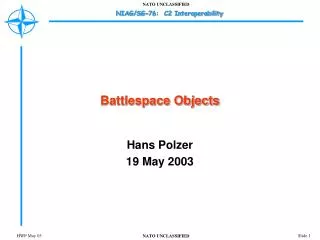
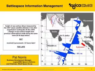
Battlespace Information Management. height of sea surface (blue) measured by the US/F Jason satellite altimeter 2 hrs after magnitude 9 earthquake 26 Dec 2004 - change of sea surface height from previous observations made along the same track 20-30 days before BUT

Battlespace Information Management
E N D
Presentation Transcript
Battlespace Information Management height of sea surface (blue) measured by theUS/F Jason satellite altimeter 2 hrs after magnitude 9 earthquake 26 Dec 2004 - change of sea surface height from previousobservations made along the same track20-30 days before BUT received & processed >12 hours later! TOO LATE Pat Norris Business Development Manager,LogicaCMG Space & Defence and Chairman, RAeS Space Group
Agenda • Information balance • Information Food Chain • Bandwidth demand fulfilment • Satcom Capabilities • Secure Multicast • Navigation • Meteorology • The future
Information Balance Is available? How much Information… Is relevant? Do you need? Do you want?
Start information management + role of satellites + affordability, safety, security + aviation, aerospace + UK regions + midlands 8,168,684,336 519,000,000 6,360,000 33,000 5,700 529 71 Information
The Information ‘food chain’- enough bandwidth in the right place at the right time
The Bandwidth Demand Curve 3.2 Gbps
2,644 Mbps 556 Mbps Bandwidth Demand
2,088 Mbps 556 Mbps Military v Commercial Satcom
Military satellite capability- secure and robust Milstar 2 (USA) AEHF (USA) WGS (USA)
Inmarsat - Broadband Global Area Network- commercial connectivity on the move • Typical services: • E-mailInstant MessagingVideo, audio and text streamingFax over IPSecure accessImage transfer “the ideal solution for multinational companies setting up rapid deployment offices in less developed countries”
Thuraya- hand-held terminal coverage for many of the world’s trouble spots 13,750 telephone circuits
Iridium- global secure voice coverage via hand-held terminal 66 low earth orbit satellites Global coverage
Skynet 5- UK’s next generation military satcom system • UHF and X-band services • Atlantic and Indian Ocean regions • first launch: mid 2006
EADS Astrium’s Skynet 5 Terminals & Satellites- exploiting the best of civil and military technologies • Eurostar E3000 bus • ‘Bent Pipe’ Comms payload • UHF • SHF • Active receive antenna • Steerable transmit antenna • 5kW Payload • 4x Skynet 4 • Launch weight 5 tonnes • Skynet 4 was 1.6 tonnes
LogicaCMG’s Management Segment for Skynet 5- commercial-quality telecom services to our forces world-wide Secret Web Restrict. Web Unclass. Web Business Support & Office Systems SAP PRN Key Management Customer Relationship Management Business & Service Management Layers 2003 Accounting & Performance Fault Management Configuration Management Terminal Manager 2004 TOM Layers Network Management Layer 2005 Baseband/HGLC EMA Space EMA PMS EMA Transmission EMA Legacy Modem EMA Element Management Layer 2006
Getting more out of the bandwidth: Secure Multicast Most content currentlydelivered individuallyto each user in orderto control security Multimedia deliveryover IP • Videostreaming and conferencing • File distribution • Internet download and caching • Database updates • Result is : • same content to 1000’s of users • huge network inefficiencies and cost • capacity problems at central servers
Why multicast? With IP Multicasting content is sent across the network once only • LogicaCMG’s Secure Multicast Platform • central control of access to services • end to end encryption of content • application and network independent • scalable to large subscriber groups
Secure multicast platform User Management System • dynamic control of subscriber groups • group and subscriber level control • denial or approval of access down to level of individuals • customer care and billing • web-based front end
Navigation • average number of munitions required to destroy a target: • in the Gulf war (1991) ~10 • in Kosovo ~5 • in the Iraq war <2 • the difference was precision guided munitions using GPS • Europe now building (officially non-military) system – Galileo • UK roles: • prime for prototype satellite (Surrey Satellite) • prime for payload (Astrium) • prime for ground segment design (LogicaCMG) GPS – 24 satellites give global coverage Galileo – first satellite built in Guildford to be launched December 2005
Location Based Services- satcom servicestailored for user’s location
Meteorology • knowledge of weather conditions crucial to successful military actions • satellites provide the bulk of the data used in current forecasts • mix of primarily WMO-coordinated civil, and USA military, satellites • UK roles: • prime for Metop - Astrium • MSG ground segment - various • MTSAT (Japan) ground segment - LogicaCMG global network of geostationary & polar orbiting satellites Europe’s weather satellites: MSG geostationary (left)and Metop/EPS polar orbiting (right)
Closing Points • Information Superiority or Information ‘Obesity’ • bandwidth is not a universal challenge • satellite communications provide reach and increasing capability • military satellite capability can/needs to be supplemented • the advent of IP across the Battlespace will enable new services to be delivered • the demand for information services will continue to increase and satellites, military and civil will be a key capability to enable future operations • information management is a key challenge • and will continue to be so – witness the USA’s next generation…
Weapons SDB II JASSM JSOW TACTOM JCM ISR Network WF IP WF C4ISR AF Constellation Net FY2013 MILSTAR ADV Polar C-130AMP AEHF/EHF DSCS Int Polar Connexion/INMARSAT INMARSAT/IRIDIUM C-5 C-37 VC-25/C-32/C-40(OSA/VIP/SAM) E-4B KC-10 E-6 CV-22 Commercial C/Ku/Ka KC-135 TSAT V-22 UHF UFO (UHF) B-1 KC-XXX ETP EC-130 C-17 UHF B-2 ETP Follow On MUOS E-3 AC/MC/HC-130 E-10 UHF MMP Tankers B-52 RC-135 Link 16 ABL TUAV MMA F/A-22 UCAV AH-1Z WGS Coalition GH E-8 F-35 (JSF) E-2C C-130J F-3 BAMS F-16 Bk40/50 P-3 Nimrod ACS F-15E U-2 AV-8B UH-1Y KC-130 F-16 Bk30? EA-6B A-10 MH-60 F/A-18 Nat SYSTEMS HH-60 SBIRS F-117? EFA F-15C/D WIN-T SBR Predator EPLRS JTEP TACP/ SOF Surface Mobile Land Mobile ASOC DCGS – ISR Processing CAOC Global Joint Ground C2 Teleport Source: AF C4ISR Flight Plan Fixed Joint Ground Infostructure IP Based Network IP Dynamic Routing Future platforms: E-10 ABL UCAV CV-22 More Aircraft connected via Link 16 Forwarding/gateway via ROBE, JTEP