Download
1 / 43
430 likes | 596 Vues
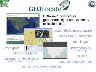
Software & services for georeferencing of natural history collections data. automated georeferencing. verification & correction. multi-lingual. kml export. interoperability. soap & rest api. batch processing. training. geographic visualization. uncertainty determination.

E N D
Software & services for georeferencing of natural history collections data automated georeferencing verification & correction multi-lingual kml export interoperability soap & rest api batch processing training geographic visualization uncertainty determination google, bing, openstreet, wms collaborative georeferencing
What is Georeferencing pushepatapa creek, trib. to pearl river, 7.8 miles north of bogalusa at hwy 21; Washington; LA; USA latitude: 30.88797longitude: -89.83601 uncertainty radius: 48muncertainty polygon: 30.88823,-89.83641, 30.88815,-89.83634, 30.88808,-89.83622…
pushepatapa creek, trib. to pearl river, 7.8 miles north of bogalusa at hwy 21; Washington; LA; USA Typical GEOLocate Workflow Data Entry &Preparation 1 AutomatedProcessing Automated Georeferencing 2 Visualize, verify & adjust output coordinates & uncertainties Manual Verification 3 latitude: 30.88797longitude: -89.83601uncertainty radius: 48muncertainty polygon: 30.88823,-89.83641, 30.88815,-89.83634, 30.88808,-89.83622…
Locality Visualization & Adjustment Computed coordinates are displayed on digital maps Manual verification of each record Drag and drop correction of records
Multiple Result Handling Caused by duplicate names, multiple names & multiple displacements Beaver Creek;Louisiana; USA Results are ranked and most “accurate” result is recorded and used as primary result All results are recorded and displayed as red arrows Working on using specimen data to limit spread of results
Representation of Uncertainty Eagle Lake,Warren County,Mississippi, USA
Uncertainty within GEOLocate Point radius (web app) and polygonal uncertainties (both) Utah Lake, UT, USA Point radius represented as a distance in meters fromgeoreferenced point Polygons represented as a comma delimited array of vertices using latitude and longitude Supports auto-detection and generation of polygons for selected places (web app only, in development for desktop app)
Georeferencing Options: My Creek at Hwy 1 My Creek 7 miles North of 7 miles North of Mythical Place Mythical Place Detect Hwy/River Crossing Match Water Body
Generating Polygons: Lawrence, KS 15 mi N of Lawrence, KS no displacement 15 mi N of Lawrence, KS displaced polygon
+BGIntegrating Results from Biogeomancer 7 miles South of Harrisburg; Poinsett; Arkansas; USA; Biogeomancer Active Marker GEOLocate
Homochitto National Forest; MS; USA Along Highway 84
A Framework for Collaborative Georeferencing DiGIR Service Remote Data Source CSV Upload Cache Update Web Service • CoGe Web Portal Application Data Retrieval Web Service Data Store • CoGe Client Application (Desktop or Web) Record Processor Insert Correction Web Service Georeferencing Web Service
A Framework for Collaborative Georeferencing Community Community Data sources Data sources Users Data sources Data sources Community Community
Georeferencing Communities CreateCommunities Data Sources Add New Users & Link Out
Georeferencing Communities Data Sources
User Management: Task Assignment Assign all records from Kenya to experts on East African regions
Collaborative Web Client Optional Hyperlink
Interoperable Services • Georeferencing Web Services • Version 1 • Version 2 • Validation • Taxon Footprint • Application • Embeddable Web Client
Georeferencing Services:GEOLocate v2 http://www.museum.tulane.edu/webservices/geolocatesvcv2/geolocatesvc.asmx SOAP & HTTP Get/Post
HTTP/1.1 200 OK Content-Type: text/xml; charset=utf-8 Content-Length: length <?xml version="1.0" encoding="utf-8"?> <Georef_Result_Setxmlns="http://www.museum.tulane.edu/webservices/"> <EngineVersion>string</EngineVersion> <NumResults>int</NumResults> <ExecutionTimems>double</ExecutionTimems> <ResultSet> <WGS84Coordinate> <Latitude>double</Latitude> <Longitude>double</Longitude> </WGS84Coordinate> <ParsePattern>string</ParsePattern> <Precision>string</Precision> <Score>int</Score> <UncertaintyRadiusMeters>string</UncertaintyRadiusMeters> <UncertaintyPolygon>string</UncertaintyPolygon> <ReferenceLocation>string</ReferenceLocation> <DisplacedDistanceMiles>double</DisplacedDistanceMiles> <DisplacedHeadingDegrees>double</DisplacedHeadingDegrees> <Debug>string</Debug> </ResultSet> <ResultSet> . . . </ResultSet> </Georef_Result_Set> Version 2 Get Response georef2()
Application Services: Web Client APIs • URL API for user input & lightweight web clients • Lightweight client, specifically designed for embedding into other web applications. • Two way communication in light client requires JavaScript postMessage() • Compatible with all modern browsers: IE 8.0+ Firefox 3.0+ Safari 4.0+ Chrome 1.0+ Opera 9.5+
Excel http://www.museum.tulane.edu/geolocate/web/WebGeoref.aspx?v=1&Country=USA&State=LA&County=Washington&Locality=Bogalusa&georef=run