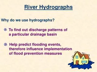
River Hydrographs: Patterns and Analysis
310 likes | 470 Vues
Learn to describe and explain river hydrograph patterns, construct and analyze hydrographs, and understand the relationship between rainfall and river flow. Discover the significance of hydrographs in tracking seasonal fluctuations and climate changes.

River Hydrographs: Patterns and Analysis
E N D
Presentation Transcript
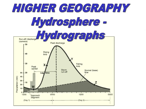
HIGHER GEOGRAPHY Hydrosphere - Hydrographs
√ CAN DOs! • describe and explain the patterns shown on a river hydrograph. • GMTs • construct and analyse river hydrographs to show the relationship between rainfall and river flow
= cross sectional area X rivers mean velocity Hydrograph Record of River Discharge over a period of time RiverDischarge (at a particular point in its course)
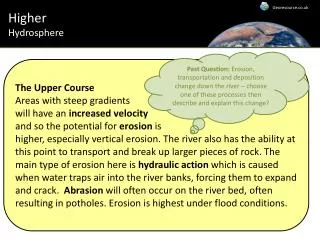
Annual hydrographs show river discharge over a year. Precipitation and discharge cover the full year. The pattern of discharge over a period of time is the RIVER REGIME
Colorado River, SW USA. Long term discharge of the Colorado
The Hydrograph as a measure of Annual Climate ChangeWhile many modern waterways are controlled by dams and reservoirs, in natural systems the hydrograph provides a climate signature that can be an important way of tracking seasonal fluctuations. The hydrograph year starts in October and ends at the end of September. The graph on the next slide shows the discharge of Boulder Creek in the Rocky Mountains near Boulder, Colorado, which is somewhat controlled by a dam upstream but still shows the basic pattern of a natural system. The unit of measure is in cubic feet per second, with the red line referring to daily mean streamflow.
Storm hydrographs show a few days only and show the changes in discharge that result from a period of rainfall.
Basic terms: Run off: the sum of all the rainwater that flows over the surface of the river basin (stream flow and overland flow) Through flow: the downslope movement of water through soil towards streams and rivers. Baseflow: groundwater movement, which often lags behind precipitation by weeks, months or even years. Stormflow: discharge that is not baseflow.
Terms to do with hydrographs: Approach segment: the discharge of a river before the storm.
Lag time: the time delay between max rainfall and max discharge. Lag time varies according to the type of drainage basin.
Rising limb: part of the graph which shows increasing discharge
Falling limb (recession limb): part of the graph which shows decreasing discharge
Bankfull discharge: the point at which a river is full. If the level increases any more, the river floods.
SUMMARY • Discharge is the amount of water passing a sampling point • It is a combination of run off, throughflow and base flow. • Overland flow is the volume of water reaching the river from surface run off • Throughflow is the volume of water reaching the river through the soil.
SUMMARY • Discharge is measured in cumecs (cubic metres per second) • Discharge of a river depends on many factors, including type of precipitation, drainage density, channel shape and slope and land use.
SUMMARY • River discharge can increase dramatically during rain storms and during snow melt. • River flow can be analysed in a storm hydrograph.
Factors influencing hydrographs
Remember! These influencing factors will: Influence each other Change throughout the rivers course
Why does a river flood? This river flooded after the second rainstorm, when the discharge reached 70 cumecs, although the first rainstorm had more precipitation. Why?
You would need to mention the following points when explaining this hydrograph.At the time of the first rainstorm: • rain water does not all fall directly into the river • water soaks into the ground • run-off takes time to reach the river • water can be intercepted by vegetation • water can be stored in soil and rock • But by the second rainstorm: • the soil and ground water stores may be full • the ground is saturated • run-off will be faster • water is still reaching the river from the first rainstorm
Comparison of impermeable mountain catchment with permeable lowland catchment area
Comparison of an area before and after urbanisation Explain the difference in the hydrographs before and after urbanisation.