Download
1 / 39
400 likes | 589 Vues
Coastal Processes and Biogeochemical Fluxes at the Land-Ocean Interface. William Balch Bigelow Laboratory for Ocean Sciences, W. Boothbay Harbor, ME

E N D
Coastal Processes and Biogeochemical Fluxes at the Land-Ocean Interface William Balch Bigelow Laboratory for Ocean Sciences, W. Boothbay Harbor, ME (With help from: George Aiken (USGS), Andrew Barnard (WETLabs), Francisco Chavez(MBARI), Marjorie Friederichs (VIMS), Tom Huntington (USGS), Steve Lohrentz (UMass Dartmouth), Antonio Mannino (NASA Goddard), Collin Roesler (Bowdoin College), Joe Salisbury (Univ. NH), Crystal Schaaf (UMass Boston), Menghua Wang (NOAA NESDIS); Huije Xue (Univ. Maine)
Descriptions of land-to-sea connections are not new… • “With the concentration of dissolved nitrogen compounds probably at least twice as high in river water as in the sea water of the gulf, the freshening of the latter, which is caused in spring by river freshets, is probably accompanied by a considerable increase in the concentration of nitrogen in the coastal zone over the values obtaining there in winter, with the alteration greatest near the mouths of the larger rivers and along the zones where their discharges have the greatest effect on salinity” Henry Bigelow; Plankton of the offshore waters of the Gulf of Maine; p. 470; 1924
Gordon Riley contemplating factors that affect the coastal zone over half a century ago… • “What is the role of freshwater drainage? How damaging are the pollution effects? Does land drainage enrich the coastal area, or is this effect insignificant compared with the transport of nutrients by physical oceanographic processes? What effect do silt and bottom sediments have on the transparency of the water and how seriously do they influence phytoplankton production and animal behavior?” Gordon Riley, “Oceanography of Long Island Sound, 1952-1954”, 1956. Bulletin of the Bingham Oceanographic Collection, p. 10,
Carbon transfer from sea-to-land- Deep Water Horizon oil spill. Nothing focused us more on the importance of coasts than that event… MODIS Terra 5-24-10
Many programs have focused on the land-sea boundary. To name a few… • Shelf-Edge Exchange Processes (SEEP) • JGOFS Ocean Margin Program- • LOICZ co-sponsored by IGBP and IHDP • IMBER- Integrated Marine Biogeochemistry and Ecosystem Research; IGBP • N. American Continental Margins Group, U.S.Carbon Cycle Science Program • US Climate Change Science Program, “The First State of the Carbon Cycle Report (SOCCR)” • And many others…
Modeling the coastal zone… • 0-D boundry in box models separating land from sea (IPCC 4th assessment Report, no fluxes or inventories of C in coastal zone) • 1-D Course-gridded open ocean models, 1D coastline separates land from ocean • 2D depiction- highlights coastal zone (marshlands/estuaries/Shelf and even slope, but misses along-shelf processes (e.g. boundary currents, eddies, trapped waves) • coupled 3D circulation/biogeochemical models
2-D views most common; LOICZ (Land Ocean Interactions in the Coastal Zone) After Pernetta and Milliman, 1995
Some thoughts and questions on coastal systems.. • Coastal margins can be C source or sink of 1Pg C y-1) (Hales et al., 2008) • Coasts: 1/3 global ocean production, ½ exported carbon (Muller-Karger et al., 2005) • Are coastal systems net auto- or heterotrophic? In mid-Atlantic bight, off-shelf export exceeds coastal influx. Net autotrophic and a carbon sink. • General rule of thumb for rivers with relatively low sediment concentrations such as in Maine and Quebec…90% of carbon export from rivers is as DOC (Maybeck 1982; Moore et al. 2011;Dahm et al, 1984; Opsahl et al.,1999; Lobbes et al., 2000; Romankevich et al., 2000)
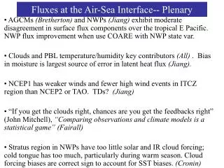
Monterey Time Series-Both source (narrow band) and sink (broad band) Time To define source vs sink requires higher resolution sampling in time and space Space Chavez et al.; SOCCR Report
Total N. American Corg discharge from rivers into estuaries… What are the error bars on these estimates? Summarized from Meybeck, 1982; Mulholland & Watts ’82; Meybeck, ’93; Ludwig et al., ’96; Aitkenhead & McDowell, ’03 Hales, Cai, Mitchell, Sabine and Schofield.; N. American Continental Margin Report; US C Cycle Science Prog
Focus on “Land-sea connections in the Gulf of Maine” NASA-Interdisciplinary Science (Balch, Aiken, Barnard, Huntington, Roesler, Xue) Research Problem: Optically-active colored dissolved organic matter (CDOM) influenced by its terrestrial origins. Defining spatial and temporal variability in GoM requires understanding CDOM export Study Area: Penobscot Watershed, River, Bay and Gulf of Maine Objective:Estimate daily DOC flux from the Penobscot River and its tributaries, transformations in river and bay, fate in GoM, modeling of DOC & POC export and algorithm development.
Gardiner Maine: wettest year in over 100+ years p p p p p p p p GNATS Of 8 years >1.4m y-1, half during GNATS Gardner Maine: 3rd driest year in 100+ years The story starts with some extreme precipitation events…
‘02 ‘03 ’04 ’05 ’06 ’07 ’08 ’09 ’10 Year This translated major years for DOC Export (incl. 2010)… Tom Huntington, USGS
The quality of colored dissolved organic matter changes in a non linear fashion as it moves from land to sea… Norm FCDOM-LOBO = -0.000175*S2 – 0.02525*S+1 A.Barnard, WETLabs; G. Aiken, T. Huntington (USGS); C. Roesler (Bowdoin)
GNATS-Gulf of Maine North Atlantic Time Series • 12+ year transect time series across Gulf of Maine (35 years if you include historical data on same line) • Sample design uses flexible schedule vessels (ferries, small research vessels) that can specifically target clear-sky days for concurrent satellite and ship measurements.
MODEL of the DOC Time Series Oct to Dec ’04 & ‘05 2004-A dry year 2005-Wettest year on record Mg DOC L-1 Xue, Univ. Maine Mg DOC L-1
Note significant step decrease in log maximum primary production after 2007 70 70 69 68 67 66 Longitude (deg W) 300 200 100 0 Dist. from Yarmouth, NS (km) Ext EMCC SS WMCC JB Pmax (mg C m-3 d-1) 300 Year round sampling 100 30 10
70 70 69 68 67 66 Longitude (deg W) 300 200 100 0 Dist. from Yarmouth, NS (km) Note step increase in log DIN after 2007…due to mixing of deeper, nutrient-rich water to surface? Decreased drawdown? Ext EMCC SS WMCC JB NO3+NO2 (mM) 3 Year round sampling 1 0.3 0.1 0.03
Note increase in river derived CDOM on west side of Gulf (competing with primary producers for light abosrption?) 70 70 69 68 67 66 Longitude (deg W) 300 200 100 0 Dist. from Yarmouth, NS (km) Ext EMCC SS WMCC JB Year round sampling
What is known about these changes? Multiple independent data fields showed step changes: • Extraordinary amounts of freshwater injected into the GOM as reflected in salinity field • Vertical mixing increased in upper 50m (temp profiles) • Surface nutrients increased • POC & PIC-specific growth rates decreased, hence decreased nutrient draw down • Chlorophyll and productivity anomalies covary (i.e. both standing stocks and rates) • Potential for competition for light between CDOM (delivered with river discharge) and chlorophyll • Other factors? Increases in grazing? (Top-down control) • Complex coastal systems make for enigmatic, counter-intuitive results
“Land-to-sea carbon export from the northeast watersheds of North America to the northwest Atlantic Ocean”- NASA IDS-Sept ’11: Balch (Bigelow), Huntington (USGS), Schaaf (UMass Boston), Aiken(USGS), Claire(Env. Canada), Nemani(NASA Ames), Boulanger(Univ. Quebec) Watersheds emptying into the NW Atlantic- 1.2 million km2 St. Lawrence Gulf of Maine watershed
Onset and decline of terrestrial productivity changes fast…we will track how this tracks through the watershed in terms of organic carbon… 8/28/04 9/29/04 MODIS true color albedo …New England foliage 10/15/04 Crystal Schaaf, U. Mass Boston
New Directions…Surface Salinity from Aquarius Joe Salisbury, Univ. New Hampshire
The first study of land – ocean dynamics using space based SSS • “Spatial and temporal coherence between Amazon River discharge, salinity, and light absorption by colored organic carbon in western tropical Atlantic surface waters” • Salisbury et al., 2011 • JGR Oceans • New opportunities with 2 new global coverage SSS sensors: • ESA’s SMOS (Soil Moisture Ocean Salinity) • NASA-CONAE AQUARIUS
GEO-CAPE coastal observations from a geostationary satellite… Continuous view from Geo at 95W • Discriminate physical from biological forcing • Rates of processes and diurnal changes • Primary productivity, photooxidation, material transport • Sub-mesoscale resolution (lateral scales <1km) • Short time scale resolution of tides, wind-driven currents, blooms) • Land-Ocean exchange • More opportunities for cloud-free viewing • Impacts of climate change and human activity • Hazardous event monitoring at high frequency time scales (oil slicks, HABs, etc.) Tracking Gulf of Mexico Oil Spill Societal Benefits • Detection and tracking of hazards • Post-storm Assessments (e.g., flood detection) • Water Quality / Ecosystem Health • Water clarity forecasting • Link data to models and decision-support tools and processes (e.g., predict hypoxic regions). Sediment transport (navigation) • Assessment of climate variability and change MODIS image
Autonomous vehicles allow higher resolution, longer duration measurements of coastal zone, below the depths that satellites can see… Balch; GNATS crossing June-July 2010
The Impact of Climate Variability on Primary Productivity and Carbon Distributions in the Middle Atlantic Bight & Gulf of Maine (CliVEC) Poster 105 A. Mannino, M. Mulholland, K. Hyde & D. Lary • Objectives • Refine and validate satellite algorithms for Primary Productivity (PP) model, POC, DOC, aCDOM and aph for the continental margin of northeastern U.S. • Examine the impacts of inter-annual and decadal-scale climate variability, including river discharge, on PP, POC and DOC. in situ Surface Ocean C fixation (μmol C L-1 d-1) overlain on MODIS SST 2004 Dissolved Organic Carbon (μmol C L-1) Aug 2009 SST (°C) MODIS-Aqua 2004
GulfCarbon: Carbon System Dynamics in the Large River-Dominated Northern Gulf of Mexico Coastal Margin Steven E. Lohrenz – U. Mass Dartmouth Wei-Jun Cai, Wei-Jen Huang, Yongchen Wang, Xianghui Guo, Feizhou Chen – U. Georgia Kevin Martin, Sumit Chakraborty, Sarah Epps, Kjell Gundersen – U. Southern Miss. Other Collaborators: Mike Murrell, John Lehrter (EPA), Bill Miller, Tim Hollibaugh (U. Georgia), Ron Benner, Cedric Fichot (NC State), John Paul (USF) Conceptual representation of major plume processes and hypothetical relationships to air-sea fluxes of CO2 Large rivers represent extremes in carbon cycling and fluxes for margins; source of uncertainty in continental and global carbon budgets Objective- characterize the fate of terrestrial inputs of carbon and nutrients and their impact on shelf and Gulf wide carbon cycling Large number of cruises conducted along coastal margin of northern Gulf of Mexico
Assessing Impacts of Climate and Land Use Change on Terrestrial-Ocean Fluxes of Carbon and Nutrients and Their Cycling in Coastal Ecosystems Steven E. Lohrenz – U. Mass Dartmouth Wei-Jun Cai – U. Georgia Hanqin Tian – Auburn Ruoying He – North Carolina State Charles Hopkinson – U. Georgia Katya Fennel – Dalhousie Stephan Howden – U. Southern Miss. Other Collaborators: Scott Denning (Colorado St.), Watson Gregg (NASA), Chris Sabine (NOAA) The effects of climate change and land-use/land-cover change on TN exports to the Gulf of Mexico as estimated by the DLEM Poster 52 NASA Interdisciplinary Science program; employs an integrated suite of models in conjunction with remotely sensed and in situ observations to describe processes controlling fluxes on land, their coupling to riverine systems, and the delivery of materials to estuaries and the coastal ocean
USECoS- U.S. Eastern Continental Shelf Carbon CyclingM Friedrichs, E Hofmann, B Cahill, K Fennel, K Hyde, C Lee, A Mannino, R Najjar, S Signorini, H Tian, J Wilkin, Y Xiao, J Xue (Poster 23) Use ocean biogeochemical and circulation models to 1) quantify coastal carbon fluxes 2) how these fluxes may be modified as a result of climate and land use change.
Synthesized data of North American coastal margins show it to be a net source of 19+/- 22 Tg C y-1 Chavez, F.P., T. Takahashi, W.-J. Cai, G. Friederich, B. Hales, R. Wanninkhof, and R.A. Feely (2007) Coastal Oceans. In: The First State of the Carbon Cycle Report (SOCCR): The North American Carbon Budget and Implications for the Global Carbon Cycle. A Report by the U.S. Climate Change Science Program and the Subcommittee on Global Change Research[King, A.W., L. Dilling, G.P. Zimmerman, D.M. Fairman, R.A. Houghton, G. Marland, A.Z. Rose, and T.J. Wilbanks (eds.)]. National Oceanic and Atmospheric Administration, National Climatic Data Center, Asheville, NC, USA, pp. 157-166.
The Yin and Yang of coastal systems… • Situated between land and the open sea, the continental shelves may become the refuse pits of developed nations and the overfished graveyard of underdeveloped countries J.J. Walsh (1988) • We may find that the vital organs in the body of Gaia are not on land surfaces but in estuaries, wetlands and muds on the continental shelves. There, the rate of carbon adjusts automatically to regulate the concentration of oxygen and essential elements are returned to the atmosphere. James Lovelock (in Mantoura et al., 1991)
Summary • Our interests in coastal processes overlap those of our forebears • Our view and modeling of the coastal zone reflect the resolution of the measurements! In terms of CO2 fluxes, they can be intense sources and sinks, depending on time and space resolution of view. • Climate change over the last century: intensifying hydrological cycle (via temperature/evaporation) and intensifying precip/river discharge in coastal northeast • Carbon transformations in watershed nonlinear with salinity-requires better resolution of measurements
Summary • Major changes in the coastal oceanography of the Gulf of Maine with record precip years (half of the highest rainfall years in 105 years have happened in last 6 years!). • Factors responsible for productivity and nutrient changes in the marine end member go counter current paradigms • New satellite tools will improve our ability to resolve carbon cycling near the coast (GEO-CAPE and NASA-CONEA Aquarius) • Sophisticated new modeling techniques promise added insights using 3-D coupled circulation/ biogeochemical views of the coastal zone.
A lot of posters to check out… Monday • 8: Dissolved Organic Matter as an Indicator of Changing Watersheds in Northern Rivers (George Aiken) • 10:Possible abrupt shift in the land uptake of carbon (Beaulieu et al.) • 11:Interannual Variability of Primary Production and Carbon Fluxes on Northeast North American Shelf: Sensitivity to Climate Change? (Cahill et al.) • 13:An Integrated Earth System Science Approach for Predicting Nutrient Transports from the Land to the Ocean (Yang et al.) • 20:The effect of river freshwater discharge on the carbon cycling of the US Eastern continental shelf: Results from a three-dimensional total dissolved organic matter model study (Xue et al.) • 21:Exports of Water, Carbon and Nutrients to the U.S. East Coast during 1901-2008 as simulated by DLEM: Results from a NASA IDS Project Tian et al.) • 22:Model-based Analyses of Nitrogen Cycling on the Middle Atlantic Bight Continental Shelf (Tian et al.) • 23:The U.S. Eastern Continental Shelf Carbon Cycling Project (U.S. ECoS) (Friedrichs et al.) • 44:Land Use and Climate Alter Carbon Dynamics in Watersheds of Chesapeake Bay (Kaushal et al.) • 52:Impacts of Climate and Land Use Change on Land-Ocean-Atmosphere Fluxes and Biogeochemical Cycling of Carbon and Nutrients in the Northern Gulf of Mexico Coastal Ecosystem (Steven Lohrenz et al.) • 61:Seasonal measurements of POC,CDOM, and DOC from the Mid-Atlantic Bight, George's Bank, and the Gulf Of Maine: Modeling Carbon distributions from discrete data and their relationship to flow through measurements of Beam attenuation and CDOM fluorescence (Novak and Mannino) • 77:Understanding Controls on Dissolved Organic Carbon Quantity and Quality in United States Watersheds (Kevin Hanley et al.) • 87:Characterizing the 2011 great flood plume of the Mississippi River (Subramaniam et al.) • 105:Satellite-derived distributions of CDOM, DOC and particulate organic matter along the northeastern U.S. continental margin (Mannino et al.) • 106:Seasonal and interannual variability in primary productivity and dinitrogen fixation along the northeastern U.S. continental margin (Margaret Mulholland et al.) Tuesday • 143: Forest Cover and Height in Topographically Complex Landscapes from MISR Assessed with High Quality Reference Data (Chopping et al.) • 172:Leaching and Decomposition of Leaves from Baltimore Urban Area - Implications for Urbaniation and Gloabl Warming on carbon cycle (Duan and Kaushal) • 175:Recent dynamics of arctic tundra vegetation: Field observations, remote sensing, and simulation modeling (Epstein et al.) • 183:Measuring phytoplankton carbon: A new method for the isolation and elemental analysis of microalgae to validate satellite derived estimates (Jason Graff et al.) • 216:Development of a long-term phytoplankton time series in the U.S. Northeast Continental Shelf Large Marine Ecosystem (Hyde et al.) • 291:Diagnosis and quantification of climatic sensitivity of carbon fluxes in ensemble global ecosystem models (Wang et al.) • 294:An Ecosystem Model Comparison on the Northeast U.S. Continental Shelf Using Data Assimilation (Xiao and Friedrichs) Wednesday • 123:Spatial scales of biogeochemical variability and image resolution for remote sensing in river plumes. (Aurin and Mannino) • 134:CDOM optical properties in the southeastern Bering Sea during summer (D'Sa et al.) • 162:Forecasting Future Land Use and Hydrology: A Case Study of the Upper Delaware River Watershed (Goetz et al.) Thank you very much!!