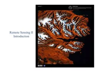
Introduction to Remote Sensing Images
Introduction to Remote Sensing Images. By: J.Verplanke, ITC. Unit: M11U01. What is remote sensing?. Remote sensing (RS) is the art, science, and technology of observing an object, scene, or phenomenon by instrument-based techniques. What is remote sensing?.


Introduction to Remote Sensing Images
E N D
Presentation Transcript
Introduction to Remote Sensing Images By: J.Verplanke, ITC Unit: M11U01
What is remote sensing? • Remote sensing (RS) is the art, science, and technology of observing an object, scene, or phenomenon by instrument-based techniques.
What is remote sensing? RS is applied in many fields, including architecture, archaeology, medicine, industrial quality control, robotics, extraterrestrial mapping, etc. The interest for this Module is, however, Earth observation from airborne or spaceborne platforms.
What is remote sensing? In this Module, aerial photographs and satellite imagery are both considered to be a type of remote sensing image.
Aerial photography Taking and using photographs is the oldest, yet most commonly applied, remote sensing technique.
Aerial photography Aerial photos are the prime data source for medium- to large-scale topographic mapping, many cadastral surveys, civil engineering projects and urban planning. Aerial photographs are also a useful source of information for foresters, ecologists, soil scientists, geologists and many others.
Aerial photography Two broad categories of aerial photographs can be distinguished: vertical photographs oblique photographs
Aerial photography In most mapping applications, vertical aerial photographs are required. Oblique photographs are obtained when the axis of the camera is not vertical. Oblique photographs are rarely used for mapping purposes.
Electromagnetic energy • Remote sensing is based on detecting electromagnetic (EM) energy. • Since the speed of light is constant, wavelength and frequency are inversely related to each other.
Visible spectrum • Visible light covers only a very small part of this spectrum.
Atmospheric interference Interactions of the Sun’s energy with physical materials cause this energy to be absorbed, scattered, transmitted and reflected.
Analog to digital An electronic sensor “measures intensity” of the terrain and the analog electrical signal is sampled in an image and converted to a digital number (DN).
Analog to digital A digital image is normally displayed using a grey scale. A pixel having the value zero is shown as black; a pixel having the value 255 is shown as white. Any DN in between becomes some shade of grey.
Analog to digital An alternative way to display single-band data is to use a colour scale to obtain a “pseudo-colour” image. Colours can be assigned (ranging from blue via cyan, green and yellow to red) to different portions of the DN range from 0 to 255.
Analog to digital Sometimes a true colour composite is made, where the RGB channels relate to the red, green and blue wavelength bands of a camera or multispectral scanner. The most striking characteristic of false colour composites is that vegetation appears in a red-purple colour.
Representation • Natural colour • Psuedo-natural • False colour
Popular spaceborne sensors • LANDSAT • (TERRA) ASTER • SPOT • ISRO • IKONOS, QuickBird, WorldView