Optimal Synergy Between Altimetry and In-Situ Data for Coastal Areas
110 likes | 221 Vues
This project aims to enhance altimeter products in coastal regions, addressing challenges near coastlines and introducing improvements using in-situ data integration. By merging high-frequency signals from Tide Gauges with altimetry data, the goal is to refine Mean Dynamic Topography in the Black Sea and IBIROOS regions. The development of a regional altimeter dataset for improved accuracy and resolution is a key focus of this initiative.

Optimal Synergy Between Altimetry and In-Situ Data for Coastal Areas
E N D
Presentation Transcript
T3.1Optimal synergy between altimetry and in-situ dataClaire Dufau (1)Enrique Alvarez (2), Ole B. Andersen (3), Florence Birol (4), Mathilde Cancet (4), Begona Perez (2), Gilles Larnicol (1), Gennady Koroatev (5),Per Knudsen (2), Arseny Kubryakov, Marie-Hélène Rio (1)(1)CLS, France(2) OPPE, Spain (3) DNSC, Danemark(4) LEGOS-CTOH, France (5) MHI, Ukrain
T3.1 General objectives • Consolidate and improve the altimeter products in regional/coastal areas • Ensure the transfer of R&D activities to operation link with MERSEA project (open ocean) link with ECOOP WP2 (operational demonstration) • Two ECOOP regions are identified to lead specific R&D studies • IBIROOS : CLS,LEGOS-CTOH,OPPE,DNSC • Black Sea : CLS,MHI
Issues for Altimetry near the coasts Standard products are not really adapted for regional use, specially near the coast due to • Specific dynamics over the continental shelves and shelf breaks show higher frequencies and shorter spatial scales aliasing on lower frequencies disturbing signal quality • Lack of accuracy in the altimetry measure corrections essentially due to the presence of land in the footprint of the sensor First way of improvements • Better management of aliasing problem • Improvement of the corrections near the coast (atmospheric, geophysical, etc.) • Use of 20Hz sampling instead of 1Hz Two Coastal Altimetry Projects have started in Europe to investigate such issues: PISTACH (CNES funded): since Autumn 2007, dedicated first to Jason-2 products (launching in June 08) COASTALT (ESA funded): since January 2008, dedicated first to ENVISAT products
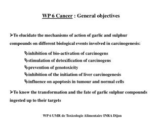
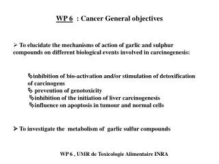
T3.1 Optimal synergy between altimetry and TG Second way of improvements • Use of in-situ data located near the coast (Tide Gauges) for adding HF signal missing in altimetry • 0bjectives of T3.1: • Analyze consistency between altimeter data sets and TG • HF signals • Tidal corrections • Measurement errors • Estimate how HF signal in in-situ data could permit to improve altimetry • Develop merging techniques • Improve Mean Dynamic Topography in the Black Sea and IBIROOS
Production of a new regional altimeter dataset: the AVISO Black Sea product Development of a regional multi-mission processing including • a higher along-track resolution (no sub-sampling) than global products • adapted filtering & adapted long-wave errors correction • a new Mean Sea Level (performed with the latest SSH dataset including new geophysical corrections ) • a refined criterion for data selection • Smaller correlation scales for mapping (gridded products) Global Regional
A new regional altimeter dataset in Black Sea Global product Regional product
Black Sea : first results of altimeter/in-situ comparison 8 coastal stations (TG) time series in 1993 and 2 in 2003 (see besides)
IBIROOS : altimetry & TG datasets • Altimeter datasets : • 2 LEGOS-CTOH products • With classical tidal correction (global model) • With regional tidal correction (regional model) • 2 CLS (AVISO) SLA-extended products • the ones developed for MERSEA • their very new version (not yet available though AVISO) • Comparison period = 2003-2005 • In-situ data = Tide Gauges : • REDMAR network (provided by OPPE) • GLOSS/CLIVAR network (provided by CLS) • SONEL network • BODC network
IBIROOS : How to compare them? • WP3.1 meeting on this topic in late December • Each partner has proposed some diagnostics that could be done such as: CORRELATIONS between the TG and altimetric sea level time series From a study made by DNSC over the North Sea From a study made by LEGOS-CTOH over the NW Med Sea
IBIROOS : How to compare them? • WP3.1 meeting on this topic in late December • Each partner has proposed some diagnostics that could be done such as: Spectral Analysis (FFT) computed with TG and altimetric sea level time series From a study made by LEGOS-CTOH over the NW Med Sea
T3.1 next steps are: • Performing altimetry & TG comparison studies over IBIROOS area • Datasets are just provided .. study is beginning. • Deadline = June 08 • Working on merging techniques between in-situ and altimetry data • Deadline = August 08 • Computing improved MDT for the 2 regions. • In progress • Deadline =August 08