Download
1 / 28
390 likes | 1.01k Vues
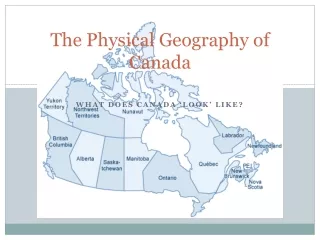
Physical Geography of the United States and Canada. Chapter 5 A Land of Contrasts. Land Area. Together the U.S. and Canada cover more than 7 million square miles. In total area, Canada ranks 2 nd and the U.S. 3 rd (Russia is 1 st ) Together they fill 1/8 of the land surface of the earth

E N D
Physical Geography of the United States and Canada Chapter 5 A Land of Contrasts
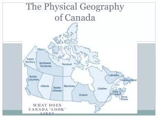
Land Area • Together the U.S. and Canada cover more than 7 million square miles. • In total area, Canada ranks 2nd and the U.S. 3rd (Russia is 1st) • Together they fill 1/8 of the land surface of the earth • An Inuit homeland, Nunavut, created in 1999 covers nearly ¼ of Canada’s land area.
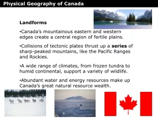
Landform Pattern • High Western Mountains: • Pacific Ranges (Alaska Range, Coast Range, Cascade Range, Sierra Nevada) • Rocky Mountains – continental divide • Highest point – Mt. McKinley (20,320 feet) in the Alaska Range
Continental Divide • Highest ridge of the Rocky Mountains is the continental divide in North America. • Separates the waters flowing west to the Pacific and to the east toward the Mississippi River and Atlantic Ocean.
Landform Pattern • Central Plains – broad, flat upland extending for about 400 miles from the Rockies through the central U.S. and Canada • Area is flat with no significant change in landforms • Great Plains • Canadian Shield
Landform Pattern • Low Eastern Mountains • Appalachian Mountains – 2nd longest mountain range in North America • 1,500 miles extending from Quebec to Alabama • North America’s oldest mountains – worn down due to erosion
The Islands • Canada – 3 huge islands in the Arctic Ocean – Ellesmere, Victoria, and Baffin • United States – 2 island chains created by volcanic activity • Aleutian Islands – off the coast of Alaska • Hawaiian Islands (politically part of the U.S., but not geographically part of North America) – about 2,400 miles to the SW of the U.S.
Bodies of Water • Mississippi River – largest river in N.A. in terms of volume and drainage area • Mackenzie River – Canada’s longest river • Many lakes were formed by glaciers during the Ice Age. • Great Lakes • HOMES • Huron, Ontario, Michigan, Erie, Superior
Land & Forests • One of the richest natural resources is the land itself. • Fertile soils make North America the world’s leading food exporter. • About 1/2 of Canada is covered by woodlands, 1/3 of the United States. • Both countries are major producers of lumber and forest products.
Mineral Resources • Gold • Silver • Nickel • Iron • Copper • Uranium • Zinc GOLD SILVER COPPER
Climate • Canada - varies from temperate in south to subarctic and arctic in north • United States - mostly temperate, but tropical in Hawaii and Florida, arctic in Alaska, semiarid in the great plains west of the Mississippi River, and arid in the Great Basin of the southwest Waikiki Beach, Honolulu, Oahu
Climate • Pacific Ranges create a rain shadow and on the leeward side are the Great Salt Lake Desert, Blackrock Desert, Mojave Desert, Death Valley. • Great Plains experience extreme weather conditions due to their distance from large bodies of water. • Most of Canada’s forests are in the subarctic region. • We live in a humid subtropical climate.
Effects of Extreme Weather • Tornado Alley – Great Plains • Hurricanes – Atlantic and Gulf Coast • Winter snowstorms • Flooding
Human/Environment Interaction • Settlement & agriculture alter the land • 1st inhabitants – nomads who migrated from Asia over Beringia, a land bridge that once connected Siberia & Alaska (hunters & gatherers) • Early settlements became permanent after agriculture replaced hunting & gathering • When people began to cultivate crops, they changed the landscape to meet their needs
Building Cities • Where do cities develop? • Depends a great deal on the physical setting • Water • Landscape • Climate • Weather • Availability of natural resources
Montreal – Adapting to the Weather • Canada’s 2nd largest city & major port • Temperature is below freezing more than 100 days a year • Located on a large island where the St. Lawrence & Ottawa rivers meet • French built a permanent settlement there in 1642 • Community was founded at the base of Mount Royal • Large areas of Montreal have been developed underground, including a network of shops & restaurants
Montreal • Underground city shops
Los Angeles – Creating Urban Sprawl • Mild climate year-round • Along the Pacific coast • City expanded into nearby valleys & desert-like foothills • During the 1980’s, L.A. became the 2nd largest city in the U.S. • Rapid expansion brought with it problems • Air pollution, inadequate water supplies, & construction on earthquake-threatened land
Transportation • St. Lawrence Seaway – North America’s most important deepwater ship route • Completed in 1950s as a joint project of the U.S. & Canada • Connects the Great Lakes to the Atlantic Ocean by way of the St. Lawrence River
Transportation • 1st Transcontinental railroad was completed across the U.S. in 1869 • A trans-Canada railroad, from Montreal to British Columbia, was completed in 1885 • Today, the U.S. has the world’s largest railway system • Canada has the 3rd largest
National Highway System • Seattle, WA
Transportation • U.S. has about 4 million miles of road; Canada has about 560,000 miles • National Highway System – network of more than 46,000 miles of highways that crisscross the U.S. • Started in the 1950s, it connects the U.S. with Canada on the north and Mexico on the south, & also runs east-west across the country.