Download

1 / 31
310 likes | 346 Vues
Explore the population, economic, cultural, and political geography of the US and Canada, including migration patterns, settlement distributions, economic activities, and regional industries. Understand factors influencing changes in settlement patterns, industrial shifts, and the impact of trade agreements.

E N D
Human Geography: • Population Geography • Economic Geography • Cultural Geography • Urban and Rural Geography • Political Geography
Questions About the US and Canada(Human Geography) • Can I analyze the effects of physical and human geographic patterns and processes on the past and describe their impact on the present, including significant physical features and environmental conditions that influenced migration patterns and shaped the distribution of culture groups today? (WG 1A) • Can I explain how political, economic, social, and environmental push and pull factors and physical geography affect the routes and flows of human migration? (WG 7B)
Questions About the US and Canada(Human Geography) • Can I locate and describe human and physical features that influence the size and distributions of settlements? (WG 6A) • Can I explain the processes that have caused changes in settlement patterns, including urbanization, transportation, access to and availability of resources, and economic activities? (WG 6B)
Questions About the US and Canada(Human Geography) • Can I compare how democracy operates in specific countries? (WG 14B) • Can I compare maps of voting patterns to make inferences about the distribution of political power? (WG 13B) • Can I assess how changes in climate, resources, and infrastructure (technology, transportation, and communication) affect the location and patterns of economic activities? (WG 11C)
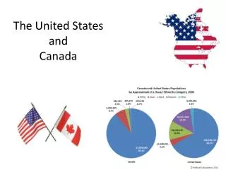
Population Geography • The population of the US is concentrated in the northeast. Why do you think this is? (WG 6A, 6B) • Historically, this is the first place colonized by Europeans • Access to international transportation routes • Canada is the world’s second largest country in area. The population of Canada is concentrated near it’s border with the U.S. Why do you think this is? (WG 6A, 6B) • Harsh climate and lack of farmland in the north • Access to economic markets
Population Geography • http://www.youtube.com/watch?v=NWNBlTyk88o • What factors led to the changes in population distribution shown in the video? How do you think the distribution of the U.S. population will change in the future? (WG 6A, 7A) • Migration to the U.S. has also changed over time. Historically, most immigrants came from Europe and settled in the Northeast. • Now, most come from Asia and Latin America and settle throughout the country but particularly in the West and South. • Immigration is a source of conflict in the U.S.
How do you think immigration to the US over this time period impacted the cultural geography of the country? What about economic geography? (WG 1A) Read the title and subtitle. Why might this graph create an incomplete picture of immigration to the US?
Economic Geography • Both the US and Canada have free enterprise economic systems. • Canada is a major exporter of minerals and agricultural products. It also has a large manufacturing and service industry. • The US has the largest economy in the world and relies heavily on global trade. • Sub-regions of the US focus on different industries.
Midwest – a major farming region and leading producer of industrial goods; contains the “Corn Belt” (Nebraska to Ohio)and the “Dairy Belt” (Wisconsin, Minnesota, Michigan) Northeast – financial center with a large transportation and trade network; was once the dominant economic area of the nation, but that has shifted in the last 50 years West – livestock, mining, tourism and high tech industries in California’s “Silicon Valley” South – historically an agricultural center but in recent decades new industries like high-tech, automobile, banking, and aerospace have been growing How do you think changes in climate, resources, and infrastructure (technology, transportation, and communication) affect the location affect the economic activities of each region? (WG 11C)
Economic Geography • Economic cooperation between the US and Canada is important to both countries. • In 1992, the US, Canada, and Mexico signed the North American Free Trade Agreement (NAFTA). This eliminated tariffs (taxes on imports) on goods flowing between these countries. Trade increased dramatically but still remains controversial because some claim that free trade allow American companies to move factories to countries with lower wages and business costs, causing unemployment in the US.
Sample STAAR Question • In the United States, regional differences in economic development are primarily due to a) settlement patterns of immigrant groups b) pressure from various religious groups c) state and federal election laws d) geographic factors in various parts of the nation
Cultural Geography - History • Both the U.S. and Canada were once populated with Native Americans. • Europeans started settling the eastern coasts of both nations in the early 1500’s. • The U.S. was settled mostly by British colonists escaping religious persecution. These settlers created 13 colonies declared their independence from Britain in 1776 during the American Revolution. • After independence, the U.S. will set up a republic system of government, first under the Articles of Confederation, which was replaced with the Constitution.
Cultural Geography - History • Immigrants will swell the American population following independence and on into the 1800’s. • Many Americans will move westward after independence, seeking better farmland and seeking riches due to the discovery of gold in California in 1849. • Many immigrants from Ireland will be displaced from that country due to a famine caused by a complete collapse of the potato crops there. • What push and pull factors do you think motivated migration to and within the US? (WG 7B) • What was the impact of the westward expansion of the US on Native Americans? (WG 1A, 6B)
Cultural Geography - History • Differences between the northern and southern sections of the US (including the use of slaves) will cause conflict for much of the early history of the US, until the Civil War erupts in 1861 between the North (Union) and the South (Confederacy). This war lasted until 1865 when the North wins. It was the deadliest war in US history. Why do you think the Civil War was the deadliest war in US history? • After the Civil War, rapid industrialization will cause cities to expand rapidly. By 1920, more Americans will live in urban than in rural areas. • In the twentieth century, the US became increasingly more involved in global issues, fighting in WWI and WWII and coming into conflict with the Soviet Union in a global rivalry known as the Cold War.
http://www.animatedatlas.com/movie.html • How did political geography and economic geography drive the expansion of the United States? (WG 6B) • War and international relations • Use of slavery • Industrialization and railroads
Sample STAAR Question • What would be the best title for this series of maps? a) Industrialization of the United States b) Sectional Conflicts in the United States c) Transportation Revolution in the United States d) Shifting Frontier of the United States
Sample STAAR Question • Which geographic advantage did the United States gain by purchasing the Louisiana Territory from France in 1803? • warm-water ports on the Atlantic coast • rich fishing areas in the Great Lakes • full control of the Mississippi River • vast coal reserves in the region west of Pennsylvania
Cultural Geography - History • Canada was also settled by European colonists, but the first major power to settle Canada was France, not Britain. They established Quebec City on the St. Lawrence River in 1608. • After a long war, however, the British will force the French settlers to leave and will then claim Canada in 1763. The British will then organize Canada into provinces and settle the eastern parts of the country. • Much like the US, the population of Canada grew and moved westward through the 1800s. The British government will create the self-governing Dominion of Canada in 1867 which included Ontario, Quebec, Nova Scotia, and New Brunswick. • Manitoba, British Columbia, and Prince Edward Island were added in the 1870s; Alberta and Saskatchewan in 1905; Newfoundland in 1949; and Nunavut in 1999. • Today, more than 31 million people live in Canada.
Cultural Geography – Language and Religion What generalizations about the US population can you make based on the information on language and religion presented in these diagrams? What does this information tell us about the influence of immigration on the culture of the US? (WG 1A)
Cultural Geography – Language and Religion • Most Canadians are English-speaking. However, in Quebec, most people speak French, and the official language is French. • Historically, there has been conflict between English and French-speaking citizens, a division that continues today. There have been two separate referendums(1980, 1995) in Quebec, attempting to gain its independence from Canada because of language differences. Both of those failed narrowly. • At the federal (national) level, Canada is officially bilingual – recognizing both English and French. • Canada’s two main religions are Roman Catholicism (42%) and Protestantism (40%).
Urban Geography • US cities have seen major changes of the last 50 years as people have moved from inner cities to suburbs. As a result, the populations of some large cities have dropped significantly, particularly in the Northeast. Businesses have also moved into the suburbs. • Cities are finding it difficult to provide services because of this loss of population and tax income.
Urban Geography • Canada’s cities are generally well managed, clean and safe. • Toronto is Canada’s largest city and is home to Canada’s largest stock exchange, major banks, and insurance companies. • http://www.travelchannel.com/video/visit-toronto-11242 • Other major cities include Montreal, Victoria, Vancouver, Calgary, and Edmonton.
Sample STAAR Question • Which is the most valid conclusion that may be drawn from the study of population patterns in the United States and Canada today? • Most of the population is concentrated in and around large urban centers. • The number of ethnic groups has declined. • The population of the South has continued to decline. • Rural areas are increasing in immigrant populations
Political Geography • Both Canada and the US are republics with a federal system. A federal system is a division of power between a central (national) government and state (called provinces in Canada) governments. The constitutions of both countries outline the powers that the national government holds and the powers that the state/provincial governments hold.
Political Geography • US states also play an important role in presidential elections. When a state’s voters cast ballots for president, they are really choosing members of the electoral college, or electors. • The number of electors from each state is equal to its members in the US House of Representatives and the US Senate. • To win the election, a presidential candidate must win at least 270 of the possible 538 electoral votes. • While each state has the same number of senators (2), the size of a state’s population determines how many seats that state gets in the House of Representatives. As a result, states with the largest populations have the most seats. • Therefore, changes in the population of each state affect the distribution of political power in the country.
Electoral College Vote - 1920 These maps show how voting patterns in the US have changed over time. Democrats (blue) once dominated elections in the South. Republicans (red) did better in the Northeast and West. Shifts in migration patterns, political attitudes, and regional economics have all played roles in this change. What does the 2008 map indicate about the relative strengths of the two major US political parties today? What role do you think immigration might play in the distribution of political power in this country? How might these maps support your answer? (WG 13B) Electoral College Vote - 2008
Sample STAAR Question • Which criticism of the electoral college system is illustrated by the information in the table? • Presidential electors frequently do not vote for the person they were pledged to support. • A person can win the presidency without winning the most popular votes. • The vote of the people in each state has little relationship to the election outcome. • Minor-party candidates often receive too many electoral votes.
Political Geography • Canada’s ties to Great Britain have remained close. Britain’s monarch is also Canada’s monarch. • However, Canada has its own prime minister and an elected parliament, or legislature. Each province also has a government headed by a minister, or premier. • Canada has three northern territories across the Arctic – Yukon, Northwest, and Nunavut territories. While they do not live in provinces, residents in the territories still have considerable control over local issues. • What are some similarities and differences in the political geography of the US and of Canada? (WG 14B)
Activity: • Design a full page travel poster for either the US or Canada. Include: • At least two hand-drawn images of physical features of the country • A list of activities that tourists can engage in (sailing, skiing, etc.) and where (a specific place – city, or physical feature like a lake) • A description of the economic activities that take place in the country • A 5-10 word slogan that tells why the country is so amazing and why people should visit (for example, Texas’ is "Texas: It's Like a Whole Other Country”)