Download
1 / 1
10 likes | 176 Vues
Modifications to Scattering Radiative Transfer in the CRTM. Tom Greenwald 1 , Ralf Bennartz 2 , James E. Davies 1 , Dave Groff 3 , and Paul Van Delst 3. 1 University of Wisconsin, Cooperative Institute for Meteorological Satellite Studies, Madison, WI

E N D
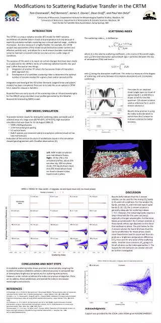
Modifications to Scattering Radiative Transfer in the CRTM Tom Greenwald1, Ralf Bennartz2, James E. Davies1, Dave Groff3, and Paul Van Delst3 1University of Wisconsin, Cooperative Institute for Meteorological Satellite Studies, Madison, WI 2University of Wisconsin, Department of Atmospheric & Oceanic Sciences, Madison, WI 3Joint Center for Satellite Data Assimilation, Camp Springs, MD • INTRODUCTION • The CRTM is a unique radiative transfer (RT) model for NWP radiance assimilation of satellite data in clouds and precipitation not only because it explicitly calculates multiple scattering over a broad spectral range - visible to microwave - but also because it is highly flexible. For example, the CRTM accepts two parameters of the model cloud distribution (water content and effective particle size), and allows for a multi-stream (variable resolution) solver to maintain consistent solution accuracy across a wide range of conditions. • The purpose of this work is to report on certain changes that have been made to or planned for the CRTM in terms of scattering radiative transfer. Our past year’s effort focused on two things: • Integration of another RT solver, the Successive Order of Interaction (SOI) approach [1]. • Development of a candidate scattering index to determine the optimal number of streams needed for a given cloud and/or aerosol profile • Integration and testing of the SOI solver (forward, tangent linear and adjoint models) has been completed. Plans are to include this as an option in CRTM V2.2, slated for release in fall 2011. • Reported here are early results of the scattering index at infrared wavelengths for the HIRS/4 using simulated cloud profiles generated by the Weather Research & Forecasting (WRF) model. SCATTERING INDEX The scattering index xs , is defined as: where s is the volume scattering coefficient, the cosine of the zenith angle, and A(z) the total absorption optical depth (gas + particles) between the top of atmosphere (TOA) and level z: with A being the absorption coefficient. This index is a measure of the degree of scattering, and varies between 0 (complete absorption) and 1 (complete scattering). The index for an idealized cloud (single-layer ice cloud of optical depth 1 at 300 hPa) is shown at left for the IASI spectrum. (16-stream solution used as reference for 2- and 4-stream solutions.) Results show promise in using the index to decide when to switch from the 2-stream to 4-stream solution for better accuracy. • WRF MODEL SIMULATION • To provide realistic clouds for testing the scattering index, we made use of selected areas of a large-scale (80oW-80oE; 50oN-50oS) high-resolution simulation that was done for 15-16 August 2006 [2]. • 5959 x 5420 grid points • 3 km horizontal grid spacing • 52 vertical levels • Bulk 5-species one-moment hybrid microphysics scheme (cloud ice has two moments)[3] • Evaluation of the vertical structure of midlatitude clouds in this simulation showed good agreement with CloudSat observations [4]. Left: WRF model simulation over mid-Atlantic Ocean. Right: Of the 256 x 256 simulated profiles, about 35% are clear sky, 20% ice phase cloud, 25% liquid phase cloud, and 20% mixed phase cloud. Ice cloud is shown in blue, liquid cloud in white. DISCUSSION Results (left) indicate that the 2-stream solution can be used for the strong CO2 bands (1-4) under all conditions. For the weaker CO2 bands, window, O3 and mid-level water vapor bands (5-10, 12), the 2-stream solution is generally adequate for scattering indexes < ~0.1. However, the remaining bands require a lower threshold (for the same accuracy), especially at longer wavelengths. Furthermore, biases are produced in the 2-stream solution at these bands whose sign depends on the cloud thermodynamic phase. The plot below for the 2-stream solution for band 18 shows that this can be problematic for mixed-phase clouds since these biases tend to cancel and thus can produce a brightness temperature difference (Tb) near zero for any value of the scattering index. Another issue concerns Tb going to 0 for all solutions as the index approaches 1. The reasons for this behavior are unclear and will be further investigated. Liquid Ice CONCLUSIONS AND NEXT STEPS A candidate scattering index shows promise in automatically assigning the number of streams needed to achieve a desired accuracy in computed top-of-atmosphere brightness temperatures for scattering atmospheres. However, under certain conditions the index can produce ambiguities. Plans are to address these weaknesses and extend the index to microwave wavelengths and aerosols. REFERENCES [1] Heidinger, A.K., C. O’Dell, R. Bennartz and T. Greenwald (2006), The successive-order-of-interaction radiative transfer model. Part 1: Model development., J. Appl. Meteor. Clim., 45, 1388-1402. [2] Otkin, J. A., T. J. Greenwald, J. Sieglaff, and H.‐L. Huang (2009), Validation of a large‐scale simulated brightness temperature data set using SEVIRI satellite observations, J. Appl. Meteor. Clim., 48, 1613–1626. [3] Thompson, G., P. R. Field, R. M. Rasmussen, and W. D. Hall (2008), Explicit forecasts of winter precipitation using an improved bulk microphysics scheme. Part II: Implementation of a new snow parameterization, Mon. Wea. Rev., 136, 5095–5115. [4] Greenwald, T. J., Y.-K. Lee, J. A. Otkin, and T. L’Ecuyer (2010), Evaluation of mid-latitude clouds in a large-scale high-resolution simulation using CloudSat observations, J. Geophys. Res., 115, doi:10.1029/2009JD013552. Acknowledgments Support was provided by the JCSDA under NOAA grant NA10NES4400007.