Download
1 / 1
10 likes | 179 Vues
Community Radiative Transfer Model (CRTM) for Satellite Radiance Data Applications. Yong Han 1(GOVERNMENT PRINCIPLE INVESTIGATOR),5 , Fuzhong Weng 1(GOVERNMENT PRINCIPLE INVESTIGATOR),5 , Paul VanDelst 2,5 , Quanhua Liu 3,5 , David Groff 2,5 , Banghua Yan 3,5 , Yong Chen 4,5 , and Ron Vogel 3,5.

E N D
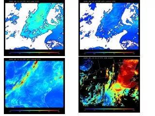
Community Radiative Transfer Model (CRTM) for Satellite Radiance Data Applications Yong Han1(GOVERNMENT PRINCIPLE INVESTIGATOR),5, Fuzhong Weng1(GOVERNMENT PRINCIPLE INVESTIGATOR),5, Paul VanDelst2,5, Quanhua Liu3,5, David Groff2,5, Banghua Yan3,5, Yong Chen4,5, and Ron Vogel3,5 1NOAA/NESDIS/STAR/SMCD, 2SAIC/NCEP, 3PGS/NESDIS, 4CIRA/NESDIS, 5Joint Center for Satellite Data Assimilation CRTM Requirement • Increase lead time and accuracy for weather and water warnings and forecasts • Improve predictability of the onset, duration, and impact of hazardous and severe weather and water events • Reduce uncertainty associated with weather and water forecasts, assessments, and decision tools • Increase development, application, and transition of advanced science and technology to operations and services • Describe and understand the state of the climate system through integrated observations, analysis, and data stewardship Science • How can satellite radiances data be accurately and rapidly simulated and assimilated into Numerical Weather Prediction (NWP) models? Benefit • National Weather Services, planned National Climate Services and their customers: • Numerical weather prediction and climate centers in assimilation of satellite radiance data in NWP and climate models • Operational institutes in generation of satellite radiance data products • Research and academic community in weather and climate studies and development of advanced space sensors • International users • What CRTM does? • Simulate satellite radiances for given atmospheric and Earth surface state variables • Compute radiance sensitivities needed for radiance assimilations and state variable retrievals • What RT components included? • Atmospheric molecular absorption and scattering (H2O, O3, CO2 and etc.) • Cloud absorption and scattering • Aerosol absorption and scattering • Surface emission and reflection for various surface types • Absorption and reflection of solar radiation • Zeeman-splitting effect • Which sensors included? • Microwave, Infrared and Visible radiometric sensors • Broadband and hyper-spectral sensors • US historical, current and future sensors; EU and other international sensors CRTM is A Poweful Tool for Satellite Radiance Data Assimilation and Used by JCSDA Partners • Numerical Weather Prediction (NWP) model needs data to initialize the state variables • CRTM can be used to map the state variables to radiances measured by satellite • With the CRTM, radiance data are assimilated into the NWP models; uses of the data have shown large impacts on forecast accuracy (see the figure on the right) • CRTM has been continuously improved and expanded by joint efforts from the JCSDA community NWP impact tests with (red, green and blue curves) and without (black curve) uses of satellite radiance data. CRTM plays a key role for assimilating radiance data in NWP model. CRTM major modules Support more than 100 Sensors GOES-R ABI; TIROS-N to NOAA-19 AVHRR; TIROS-N to NOAA-19 HIRS; GOES-8 to 14 Imager GOES-8 to 14 sounder; Terra/Aqua MODIS; METEOSAT-SG1 SEVIRI; Aqua AIRS, AMSR-E AMSU-A, HSB; NOAA-15 to 19 AMSU-A; NOAA-15 to 17 AMSU-B; NOAA-18, 19 MHS; TIROS-N to NOAA-14 MSU; DMSP F13 to 15 SSM/I; DMSP F13,15 SSM/T1; DMSP F14,15 SSM/T2 DMSP F16-20 SSMIS; Coriolis Windsat; TiROS to NOAA-14 SSU; METOP-A IASI AMSUA, MHS, HIRS, AVHRR; FY-3 IRAS, MWTS, MWHS, MWRI; NPP/NPOSESS CrIS/ATMS CRTM for simulating radiation intensity measured by satellite-based radiometers CRTM major modules Science Challenges • Surface emissivity/reflectivity for surface sensitive channels over land are difficult to model to meet operational requirements • Cloudy radiances have not been assimilated into NWP models due to a number of difficult issues such as cloud mass inhomogeneity across the radiance footprint Next steps • Improve surface emissivity/reflectivity models and data bases for various land types, • Implement the Bidirectional Reflection Distribution Functions (BRDF) model • Improve CRTM performance under cloudy conditions Transition Path • CRTM has been used in NCEP GFS and NESDIS Microwave Integrated Retrieval System (MIRS) and, therefore, new development and improvements in CRTM model can be rapidly applied in operations • New version is delivered directly to NOAA/NCEP and a note of the new released is sent out through email to all other registered CRTM users. Retrieved Water vapor from NOAA-18 CRTM Used in Calibration, Sensor Design and State Variable Retrieval Observation minus CRTM simulations before and after the SRF shift • A tool for radiance monitoring and calibration • A model for sensor design and impact studies through the Observing System Simulation Experiments (OSSE) • A key component in retrieval systems to derive atmospheric and surface parameters • A model to generate proxy data for future sensors such as the GOES-R and JPSS sensors CRTM is a key component of NOAA Microwave Retrieval System (MIRS) CRTM is used to determine frequency shift for GOES-12 channel-14 spectral response function (SRF). Radiance error is largely reduced (by ~6K). Example of NCEP radiance monitoring plots (CRTM simulated – observation) for NOAA-15 AMSUA ch1-4. http://www.emc.ncep.noaa.gov/gmb/gdas/radiance/esafford/opr CRTM simulated GOES-R ABI radiance in the 0.64μchannel observing deep convective clouds over Arizona and off the coast of South Carolina. (R. Bradley Pierce et al.)