The Earth as a Rotating Planet
310 likes | 519 Vues
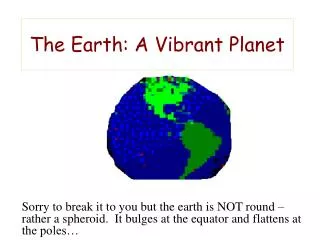
The Earth as a Rotating Planet. Chapter 1. The Shape of the Earth. Earth or Sun moving? Early sailors view…… Is the Earth a perfect sphere? (Quasi-sphere)*—Rotation causes it to bulge at the Equator and flatten at the Poles * Oblate Spheroid. Earth Rotation. What is rotation?

The Earth as a Rotating Planet
E N D
Presentation Transcript
The Earth as a Rotating Planet Chapter 1
The Shape of the Earth • Earth or Sun moving? • Early sailors view…… • Is the Earth a perfect sphere? • (Quasi-sphere)*—Rotation causes it to bulge at the Equator and flatten at the Poles *Oblate Spheroid
Earth Rotation • What is rotation? • What direction does the Earth rotate? • How long does it take to rotate? • 3 main effects of rotation • Why is rotation important? • Axis serves as reference for geographic grid (latitude and longitude) • Measure for time (time zones) • Affects physical and life processes
Earth Rotation Figure 1.2 (P. 26)
The Geographic Grid • What is a geographic grid? • A system for locating or determining the location of places on the Earth’s surface • Demarcations for hemispheres • Latitude-Distance N or S of the Equator (0 degrees latitude) **Parallels • Tucson is approximately 30 degrees North • Longitude-Distance E or W of the Prime Meridian (0 degrees longitude)
A few more points about the latitude and longitude... • Location of a point is given as: • latitude (in degrees N or S), longitude (in degrees E or W) • There are two techniques for indicating a more detailed location: • Decimal degrees: 32.13° • Degrees, minutes, seconds: 32° 07’ 48”
Examples • What city is located at 37°S and 144°E? • Melbourne, Australia • What city is located at 40°N and 105°W? • Denver, CO • What city is located at 51°N and 0°W? • London, England • Distances: Given the fact that the circumference of the Earth is 24,860 miles and there are 360° in a circle—How many miles are there in 1 ° of longitude at the Equator?
Calculating Distances between Lines of Latitude • Latitude=(69 miles) x (difference in degrees latitude) • Example 1: Calculate the number of miles between Atlanta (33°N, 84°W) and New York City (40°N, 74°W). • Latitude=(69) x (7°)=483 miles • Example 2: Calculate the number of miles between Prague (50°N, 14°E) and Tripoli, Libya (32°N, 13°E). • Latitude=(69) x (18°)=1,242 miles
Calculating Distances between Lines of Longitude (**Difficult) • Longitude=(69 miles) x (COS of parallel traveled) x (difference in degrees long.) • Example 1: Calculate the number of miles between Cairo, Egypt (30°N, 31°E) and New Delhi, India (28°N, 77°E). Assume travel along the 29°N parallel. • Longitude=(69) x (COS 29) x (46°)=2,777 miles
Map Projections • A map is just an abstraction or representation of the real world. The art and science of map-making is called cartography. • When you are trying to represent a curved surface on flat paper, you get distortion. Why? • Map units
From Earth to a map • Start with ellipsoid • Difficult, if not impossible, to take a curved surface and place it on a flat surface • Result is distortion • All maps have some type of distortion
Five Types of Distortion +1 more TypeExample • Shape Circle becomes oval • Scale Map scale changes • Area Land mass gets bigger • Distance Space between cities increases • Direction Line varies: N to NW
Polar Projection • Characteristics: a circular map centered on North or South Poles and usually showing one hemisphere at most; meridians are straight lines; parallels are circles • Advantage: Preserves shapes • Disadvantages: scale and area distortion
Mercator Projection • A type of conformal projection • Characteristics: rectangular; meridians and parallels are both straight lines • Advantage: straight line drawn on map represents a constant compass direction • Disadvantages: scale, area, and distance distortion
Goode Projection • A type of equal-area projection • Characteristics: odd shape; meridians both straight and curved lines; parallels are straight lines • Advantage: Preserves area • Disadvantage: shape distortion
Global Time • How many world time zones? US? • Not exact…why? • Solar noon: period when Sun appears to be highest in the sky • Lines of longitude used for time zones • 15° of longitude = 1 hr of time (360° in one rotation ÷ 24 hrs = 15° per hour) • Example 1: If it is 1 a.m. in Washington D.C., what time is it in Honolulu, Hawaii? • 8 p.m • Example 2: If it is Noon in Charlotte, NC, what time is it in Madrid, Spain? • 6 p.m.
Global Time (cont’d) • International Date Line • Located approximately along 180° • Why? 180° ÷ 15° per hr = 12 hr. So if it’s 1pm on the Prime Meridian, the IDL is 1am (next day). • West adds a day • East subtract a day • Daylight Savings Time • Midnight Meridian—the meridian that is experiencing midnight (the midnight meridian is NOT stationary)
Time Examples • If it is 10 a.m. in Santiago, Chile on Tuesday, May 25, what is the time and date in Taipei, Taiwan? • 10 p.m. the same day • If it is 1 p.m. in Juneau, Alaska on Saturday, June 12, what is the time and date in Tokyo, Japan? • 7 a.m. the next day (June 13)
Longitudnal Time Problems • Example 1: If you depart Washington D.C. (33°N, 77°W) at Noon, at what speed would you have to travel to arrive in Denver, CO (39°N, 105°W) at Noon? Assume travel along the 35°N parallel. • Miles=(69) x (COS 35) x (28°)=1,582 miles • 1,582 miles / 2 = 791 mph • Example 2: If you depart Philadelphia, PA (40°N, 75°W) at 1 p.m., at what speed would you have to travel to arrive in Seattle, WA (48°N, 122°W) at 2 p.m.? Assume travel along the 45°N parallel. • Miles=(69) x (COS 45) x (47°)=2,293 miles • 2,293 miles / 4 = 573 mph
Earth’s Revolution • Movement of the Earth around the Sun • Counterclockwise if viewed from above • One revolution = 365.242 days = 1 yr • Responsible for: • Seasons • Amount of daylight (along with Earth’s tilt)
Earth’s Revolution (cont’d) • When viewed from above, notice that path of Earth is not a perfect circle, but an ellipse or oval. • Perihelion: • When Earth is closest to the Sun • Occurs in January (Northern Hemisphere winter) • Aphelion: • When Earth is farthest from the Sun • Occurs in July (Northern Hemisphere summer)
Earth’s Revolution (cont’d) • Along with perihelion and aphelion, other times in revolution also have specific names: equinoxes and solstices.
Equinoxes • March (vernal) and September (autumnal) • Sun’s rays hit equator at 90° (subsolar pt.) • All latitudes receive ~12 hrs of daylight • Circle of illumination from North Pole to South Pole
Solstices • Occur in June (summer) and December (winter) • Subsolar point in June: Tropic of Cancer (23.5°N); in Dec: Tropic of Capricorn (23.5°S) • June solstice: areas from 66.5°N to North Pole receive 24 hrs of daylight (movie – “Insomnia”) • Winter solstice: areas from 66.5°S to South Pole receive 24 hrs of daylight