Geostationary Lightning Mapper (GLM)
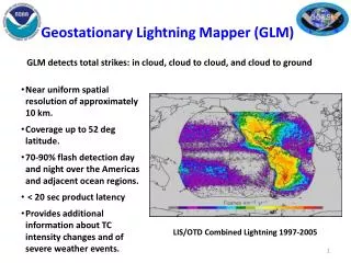
Geostationary Lightning Mapper (GLM). GLM detects total strikes: in cloud, cloud to cloud, and cloud to ground. Near uniform spatial resolution of approximately 10 km. Coverage up to 52 deg latitude. 70-90% flash detection day and night over the Americas and adjacent ocean regions.

Geostationary Lightning Mapper (GLM)
E N D
Presentation Transcript
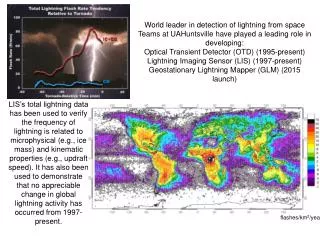
Geostationary Lightning Mapper (GLM) GLM detects total strikes: in cloud, cloud to cloud, and cloud to ground • Near uniform spatial resolution of approximately 10 km. • Coverage up to 52 deg latitude. • 70-90% flash detection day and night over the Americas and adjacent ocean regions. • < 20 sec product latency • Provides additional information about TC intensity changes and of severe weather events. LIS/OTD Combined Lightning 1997-2005
2011 NHC Proving Ground Products Rapid Intensification Index (RII) Mark DeMaria / John Knaff
Lightning-Based Tropical Cyclone Rapid Intensification Index (RII) • Ground-based lightning data used as a proxy for GOES-R GLM • NHC real-time rapid intensification index (RII) • Input from GFS model, GOES imagery, oceanic heat content analyses, Reynolds SST, persistence • Discriminant analysis provides probability of max wind increase of at least 30 kt in 24 hr • Experimental version adds lightning density input • 6 hr storm-relative composites • 2005-2010 developmental sample from WWLLN • Real time in 2011 from WWLLN feed at CIRA • Last year Vaisala used in real time, which introduced additional source of error • Text product distributed from CIRA • Analogous to text product for operational RII
6 hour WWLLN Lightning Strikes -- Hurricane Omar 16 Oct 2008 RII predictors include inner core (0-100 km) and rainband (200-300 km) lightning strike density
Sample Text Output from 2010 product Lightning-Based Rapid Intensification Forecast Algorithm Hurricane Alex 30 June 2010 00 UTC Will be available at:ftp://rammftp.cira.colostate.edu/demaria/NHCPG
Summary of 2011 RII Changes • WWLLN used in real time, consistent with developmental sample • Output will also include rapid weakening probability • Max wind decrease of 20 kt or more in 24 hr • Valid for storms over water