Download
1 / 1
10 likes | 145 Vues
Using HyspIRI at the Land/Sea Interface to Identify Phytoplankton Functional Types. Raphe Kudela (PI), UC Santa Cruz, Santa Cruz, CA

E N D
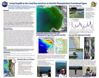
Using HyspIRI at the Land/Sea Interface to Identify Phytoplankton Functional Types • Raphe Kudela (PI), UC Santa Cruz, Santa Cruz, CA • Liane Guild (co-PI), NASA Ames Research Center, Moffett Field, CASherry Palacios, ORAU NPP Fellow, NASA Ames Research CenterKentra Hayashi, Jennifer Broughton, UC Santa Cruz Pinto Lake Field Site Meso-eutrophic lake, dominated by cyanos in summer with clear seasonal species succession. Pinto Lake has also been used as a site for airborne data collection in 2010 and 2011, and there are historical biooptical and reflectance data available for comparison. Abstract • There are many properties of biological interest in the coastal ocean, e.g., river plumes, kelp beds, and phytoplankton including harmful algal blooms (HABs), and similar targets at the land/sea interface (e.g. estuaries, coastal lakes). These properties are associated with salinity, temperature and radiation gradients but are spatially aliased with conventional 1 km resolution data. With funding from past NASA projects we have demonstrated that hyperspectral airborne data can be inverted to identify phytoplankton functional types (PFTs), including discriminating between dinoflagellates and diatoms, a distinction that has been difficult to make using past algorithms and data sets. HyspIRI has the potential to greatly improve our understanding of ecological processes at the land-sea interface due to both improved spatial and spectral resolution. We propose to directly assess whether it can provide adequate signal in these complex systems to address questions of algal bloom dynamics, water quality, and transient responses to (e.g.) human disturbance, river runoff, and red tides. Our objective is to directly test the capabilities of HyspIRI (using AVIRIS or similar) by providing an end-to-end assessment of image acquisition, atmospheric correction, algorithm application, and ground truthing. This will build on ~5 years of airborne campaigns in the Monterey Bay region as part of the NOAA COAST program, NASA COAST-HOPE, and NASA SARP. We will also build on preliminary data collections (COAST-HOPE and SARP) that demonstrated our ability to detect and quantify cyanoHABevents in coastal lakes. • Monterey Bay is well characterized oceanographically, provides rich historical and ongoing observations, and has been used in the past for both cal/val and science airborne operations including the October 2011 Coastal and Ocean Airborne Science Testbed (COAST) mission conducted using similar parameters proposed here. Based on past experience and typical conditions, we expect that an autumn (October) mission will maximize the likelihood of data collection days, minimize cloud cover, and will provide a range of scientifically interesting features, including tidal exchange with Elkhorn Slough, red tides, upwelling versus oceanic conditions, and, potentially, a “first flush” rain event. This is also the peak cyanobacteria harmful algal bloom (cyanoHAB) period in local lakes and reservoirs. Complementary data collection in other seasons will provide an opportunity to document diatom-dominated upwelling in the coastal ocean (spring), and low biomass (low signal) conditions in winter. This proposal directly builds on the expertise and experience of previous NASA airborne remote sensing programs, including the NASA COAST project. The PIs have a strong track record utilizing the MAS, MASTER, and JPL AVIRIS instruments, and UCSC hosted the HES-CW risk reduction activities prior to the cancellation (by NOAA) of the mission. We will leverage this rich historical data set and ongoing field campaigns funded by other agencies to maximize data and science return for the HyspIRI simulations. This includes access to ship time in both Monterey and Southern California funded by a NOAA sponsored ECOHAB project. Monterey Bay Chlorophyll (and toxin) samples have been collected weekly for ~3 years from Pinto Lake, CA. Weekly CHL data are plotted after degrading to 19- and 38-day repeat cycles. Seasonality, Measurement Sites, and AVIRIS/MASTER Flight Planning 2013 and 2014 Bay Area ER-2 Flight April 10, 2013 Ocean Stations Goal The primary scientific goal of this proposal is to demonstrate the utility of an airborne HyspIRI simulation to address the biological properties of coastal California, within the context of the long-term monitoring programs ongoing in the area. Objectives 1) The development and improvement of algorithms and models for the detection and prediction of HABs 2) Provide Phytoplankton Functional Types (PFTs) for inland water bodies such as lakes and reservoirs 3) Provide PFTs for the coastal ocean to assess ecosystem health and water quality (focusing on HABs and red tides) • Spring (March), Summer (July), and Fall (October) will maximize the likelihood of data collection days, minimize cloud cover (for collection of satellite data), and will provide a range of scientifically interesting features, including tidal exchange with Elkhorn Slough, red tides, fall transition, upwelling versus oceanic conditions, and, potentially, a “first flush” rain event. • Seasonality in Monterey Bay can be delineated by • upwelling (April-August), • oceanic (September-October), and • Davidson (November-March) seasons. • Having up to three AVIRIS overflights may enable • capturing some of this seasonality. Monterey Bay as a Testbed • During flights, we obtained MODIS Aqua and Terra and HICO, data corresponding to contemporaneous deployment of the ship-based measurements from the R/V John Martin (Moss Landing Marine Lab). Satellite observations will be used to compare accuracy of radiance retrievals and derived products versus the AVIRIS imaging spectrometer and the in situ measurements. Spectrally invariant bright target data were also collected for calibration and sunphotometer data were collected for atmospheric correction. Monterey Bay has both open ocean and optically complex water masses, so the full dynamic range of the sensor suite and protocols being used in the field can be evaluated Monterey Bay has been used for COAST 2006 (SAMSON sensor), COAST-HOPE 2011 (Headwall and C-AIR sensors), PRISM (2012), SARP (MASTER, 2010), and GLIMMER (2012) as well as numerous AVIRIS overflights Ongoing time-series by UCSC, MLML, MBARI, with moorings and shore stations Features include Elkhorn Slough, Case 1 and 2 waters, red tides, kelp beds, river plumes Funding: NASA HyspIRI Preparatory Project, Woody Turner