Future Radar and Satellite Technology
Future Radar and Satellite Technology. Daniel C. Miller National Weather Service Columbia, SC. The Big Idea. New radar and satellite technology will improve NWS operations!. Outline. Introduction Part I. Dual-Polarization Radar Technology Benefits What is it? Applications When?


Future Radar and Satellite Technology
E N D
Presentation Transcript
Future Radar and Satellite Technology Daniel C. Miller National Weather Service Columbia, SC
The Big Idea New radar and satellite technology will improve NWS operations!
Outline • Introduction • Part I. Dual-Polarization Radar Technology • Benefits • What is it? • Applications • When? • Part II. Next Generation Weather Satellite • Benefits and New Features • Applications • When? • Conclusion
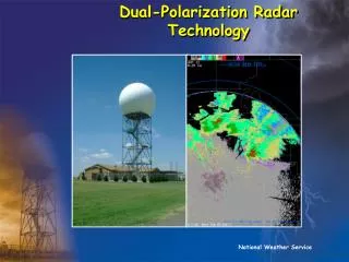
Part I. Dual-Polarization Radar Technology Photo courtesy of NSSL
Dual-Polarization Radar TechnologyKey Benefits Better Determination of Precipitation Type Better Estimates of Rainfall Amount Better Detection of Hail
How Is Dual-Polarization Radar Technology Useful? Image courtesy NSSL
How Is Dual-Polarization Radar Technology Useful? Dual-Polarization Radar tells us about the size, shape, & variety of objects. –=Size (|+–)=Shape σ(|+–)=Variety Image courtesy NSSL
Differential Reflectivity (ZDR) ZDR ~ 10log (Ph/Pv) (dB) Pv Pv Ph Ph Ph~ Pv ZDR ~ 0 Ph>> Pv ZDR >> 0
Differential Reflectivity (ZDR) Applications Reflectivity (ZH) Differential Reflectivity (ZDR) Image courtesy CIMMS-OU
Differential Reflectivity (ZDR) Applications Reflectivity (ZH) Differential Reflectivity (ZDR) Hail !! Image courtesy CIMMS-OU
Correlation Coefficient (CC) • A statistical correlation that describes the similarities in the backscatter characteristics of the horizontally and vertically polarized echoes. • It is a good indicator of regions where there is a mixture of precipitation types, such as rain and snow.
Using CC to Differentiatebetween Rain & Snow What precipitation is liquid, frozen, or mixed Frozen Melting Liquid 2.4o Correlation Coefficient Product 2.4o Reflectivity Product Image courtesy NSSL
Specific Differential Phase (KDP) • Measures the rate of change of horizontally and vertically-polarized phase shift with distance • Improves Precipitation Amount Estimates • Detects where most liquid water content is • Removes effect of hail contamination
When will Dual-Polarization Radar Technology Arrive? • 4 NWS beta test sites Fall 2010 • Nationwide installation 2011-2012 • Columbia, SC (CAE)
Summary of Benefits with Dual-Polarization Radar Technology Better Determination of Precipitation Type Better Estimates of Rainfall Amount Better Detection of Hail
Part II. Next Generation Geostationary Operational Environmental Satellite (GOES-R)
GOES-R New Capabilities Higher Resolution Images Data Received in More Frequent Time Intervals A Large Suite of New Products
Comparison of GOES-R Imagerto current GOES GOES-RCurrent Spectral Coverage 16 bands 5 bands Visible Resolution 0.5 km ~1 km IR/WV resolution 2 km ~4-8 km Full disk Every 15 min Every 3 hr CONUS Every 5 min Every 15 min Mesoscale Every 30 sec! N/A
Comparison of GOES-R Imagerto current GOES GOES-RCurrent Spectral Coverage 16 bands 5 bands Visible Resolution 0.5 km ~1 km IR/WV resolution 2 km ~4-8 km Full disk Every 15 min Every 3 hr CONUS Every 5 min Every 15 min Mesoscale Every 30 sec! N/A
Example of Visible Loop Using 1-Min Images Courtesy Timothy J. Schmit, NOAA/NESDIS/STAR Madison, WI
Comparison of GOES-R Imagerto current GOES GOES-RCurrent Spectral Coverage 16 bands 5 bands Visible Resolution 0.5 km ~1 km IR/WV resolution 2 km ~4-8 km Full disk Every 15 min Every 3 hr CONUS Every 5 min Every 15 min Mesoscale Every 30 sec! N/A
GOES-R New Capabilities (Cont’d) Provide Better Detection and Measurements of: Cloud Structure Type, Height, Phase, & Temperature Other Atmospheric Elements: Wind, Moisture, & Temperature Lightning
Some Applications of New GOES-R Data: • Improved Convective Initiation Predictions • Identification of Severe Weather Precursors • Improved Rainfall Amount Estimates • Better Estimates of Tropical Cyclone Intensity • Identify Areas of Turbulence and Icing • Improved Input to Numerical Weather Prediction Models
Some Applications of New GOES-R Data: • Improved Convective Initiation Predictions • Identification of Severe Weather Precursors • Improved Rainfall Amount Estimates • Better Estimates of Tropical Cyclone Intensity • Identify Areas of Turbulence and Icing • Improved Input to Numerical Weather Prediction Models
How will GOES-R improve warning lead times? • Rapid Cloud top cooling detection
Convective Initiation • Detections of Rapid Cloud Top Cooling • can precede precipitation reaching the surface by 30-60 minutes • precedes first cloud-to-ground lightning strikes Images Courtesy CIMSS-UW Madison
How will GOES-R improve warning lead times? • Rapid Cloud top cooling detection • Severe Thunderstorm Structures Better Detected and Monitored
Severe Thunderstorm Structures Better Detected and Monitored • Overshooting tops • Collapse of overshooting top can precede severe weather/tornado on ground
Severe Thunderstorm Structures Better Detected and Monitored • Overshooting tops • Collapse of overshooting top can precede severe weather/tornado on ground
Severe Thunderstorm Structures Better Detected and Monitored • Overshooting tops • Collapse of overshooting top can precede severe weather/tornado on ground • Enhanced-V Signature • Usually related to Supercell/Severe Weather
Severe Thunderstorm Structures Better Detected and Monitored • Overshooting tops • Collapse of overshooting top can precede severe weather/tornado on ground • Enhanced-V Signature • Usually related to Supercell/Severe Weather
How will GOES-R improve warning lead times? • Rapid Cloud top cooling detection • Severe Thunderstorm Structures Better Detected and Monitored • Better Rainfall Estimates • Real-Time Lightning Monitoring (GLM)
Geostationary Lightning Mapper • Real-Time detection of lightning across most of the Western Hemisphere • Flash Rate and Trends • IC/CC as well as CG lightning
When? • GOES-R Launch scheduled for Fall 2015
When? • GOES-R Launch scheduled for Fall 2015 • Operational with products available 2016
When? • GOES-R Launch scheduled for Fall 2015 • Operational with products available 2016
Summary of GOES-RNew Capabilities and Applications Higher resolution images received in more frequent time intervals A large suite of new products and applications
Conclusion • New radar and satellite technology will result in improved forecast and warning operations.
Conclusion • New radar and satellite technology will result in improved forecast and warning operations.
Links • Dual-Polarization Radar • NWS ROC http://www.roc.noaa.gov/WSR88D/ • NSSL http://www.cimms.ou.edu/~schuur/radar.html • Next Generation Weather Satellite (GOES-R) • http://www.goes-r.gov/
Q&A? Comments?
Thank You! • Daniel C. Miller • National Weather Service • 2909 Aviation Way • West Columbia, SC 29170 • 803.822.8133 • daniel.miller@noaa.gov