Download
1 / 12
120 likes | 246 Vues
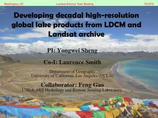
Developing decadal high-resolution global lake products from LDCM and Landsat archive. PI: Yongwei Sheng Co-I: Laurence Smith Department of Geography University of California, Los Angeles (UCLA) Collaborator: Feng Gao USDA-ARS Hydrology and Remote Sensing Laboratory, .

E N D
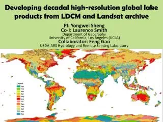
Developing decadal high-resolution global lake products from LDCM and Landsat archive PI: Yongwei Sheng Co-I: Laurence Smith Department of Geography University of California, Los Angeles (UCLA) Collaborator: FengGao USDA-ARS Hydrology and Remote Sensing Laboratory,
Current Status of Lake Inventory • Meybeck (1995) estimation: • 1.25 M lakes (>10 ha) in 2.6 M km2; • 7.2 M lakes (1-10 ha) in 0.2 M km2. • Downing (2006) projection: • 304 million lakes and ponds in 4.2 M km2. • GLWD (2004): • 0.25 M lakes (>10 ha); • SWDB (SRTM Waterbody): • 0.58 M lakes; • 56oS – 60oN; • No systematic inventory.
Objectives • To produce decadal high-resolution systematic global lake products using circa 2000 ETM+ and circa 2015 LDCMOLI images, respectively. • To access lake dynamics at global scales; • Automated and replicable mapping: • Millions of lakes (>1 ha); • ~20,000 Landsat scenes acquired at appropriate seasons.
Previous Accumulation • West Siberia (Smith, Sheng et al. 2005) • Tibetan Plateau (Sheng and Li, 2012) • Himalaya (Li and Sheng, 2012) • Pan-Arctic (45oN and north): • ~39 M km2; • 4,000 Landsat scenes; • >5 M lakes (>0.5 ha).
Challenges to Remote Sensing of Global Lake Dynamics • Characteristics of lakes: • Abundant in small-size classes; • Various types of lakes; • Variant from season to season; • Stable season variant from region to region. • Critical issues: • Large quantity of high-resolution images! • >8,000 scenes of cloud-free Landsat images. • Images to be acquired in “appropriate” detection season; • Robust lake dynamics mapping techniques: • Replicability and Automation! • QA/QC.
Hierarchical Lake Mapping Tibetan salt lakes
Interactively adjust NDWI threshold QA/QC • Semi-automated tools to reduce labor work.
Outputs • Global lakes 2000; • Global lakes 2015; • Possible by-products: • Global rivers 2000 and 2015; • 2015 ocean shorelines.
Future Plans • RT/Near-RT operational water mask products for next decade’s Landsat missions. • Robust techniques; • 2015 product as the baseline.