Landsat Data Continuity Mission (LDCM) USGS Project Status Report
110 likes | 324 Vues
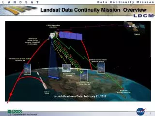
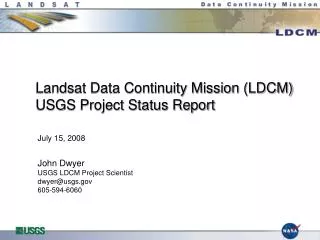
Landsat Data Continuity Mission (LDCM) USGS Project Status Report. July 15, 2008 John Dwyer USGS LDCM Project Scientist dwyer@usgs.gov 605-594-6060. Topics. Ground system development status USGS acquisition strategy status USGS LDCM Project Team update “High Volume User” survey results

Landsat Data Continuity Mission (LDCM) USGS Project Status Report
E N D
Presentation Transcript
Landsat Data Continuity Mission (LDCM) USGS Project Status Report July 15, 2008John DwyerUSGS LDCM Project Scientistdwyer@usgs.gov605-594-6060
Topics • Ground system development status • USGS acquisition strategy status • USGS LDCM Project Team update • “High Volume User” survey results • Long Term Acquisition Plan (LTAP) Development
Ground System Development Status • Participated in LDCM Mission Definition Review (MDR) • Ground System received 5 Requests for Action (RFAs) - all have been closed • Preliminary design work for elements (except MOE) in work • Element PDR completed for the Collection Planning Activity Element (CAPE) • All others Element PDRs planned for this summer (next slide) • Ground System Preliminary Design Review targeted for early Dec 2008 • Significant progress made on LTAP-8 definition and algorithm development for Automated Cloud Cover Assessment (ACCA) • Details will be covered in other presentations today
Ground System PDR currently planned for December 2008 Element PDR plans: Element PDR Plans Actual dates are subject to concurrent mission activities or availability of panel members
USGS LDCM Procurement Status • Ground system development and engineering support services contracts were awarded in March 2008 • Landsat Data Continuity Contract (LDCC) was awarded to SAIC • EROS Technical Support Services Contract (TSSC) was awarded to SGT • Flight Ops Team (FOT) procurement: Source selection in process • MOC Facility (at EROS): Facilities modification engineering and design work is in process and will complete by Oct 2008 • Construction contract is planned for FY2009
USGS LDCM Project Team USGS HQ LRS Program Bruce Quirk / Tim Newman LDCM Project Manager Mike Headley Development Manager Tom Hays Landsat Science Team Manager Dr. Tom Loveland NASA LDCM Project Mgr Bill Ochs Project Scientist - John Dwyer Scientist – M. Bouchardr**** Cal/Val Lead - Ron Morfitt**** LDCC Manager - Doug Jaton*** TSSC Manager – Willy McElroy**** Chief Engineer Tom Kalvelage Technical Resource Manager Dave Hair TSSC Engr - Jim Nelson**** TSSC SE – Jason Williams**** Financial Analyst - Matt Nelson Admin Assistant - Christine Madigan CM - Ron Stumpf**** Contactor Key * The Aerospace Corp ** Flight Ops Team (TBD) *** LDCC (SAIC) **** TSSC (SGT) GS Integration Lead Doug Daniels* Int’l Ground Station Network Manager Steve Labahn GS Support Lead - Kari Wulf**** Scheduler - Jay Ugofsky**** Data Processing and Archive Segment Manager Karen Zanter Flight Operations Segment Manager Steven Walters Integration and Test Systems Engineer Rodney Pater Flight Systems Manager Steve Walters (acting) FOT Lead - TBD** USGS SE - Brian Sauer LDCC Lead - Steve Zahn*** TSSC Lead - Dave Willard**** USGS SE - Grant Mah LDCC Lead - Joel Nelson***
High Volume Data Distribution RFI • Distributed through various email list servers • Landsat Newsletter subscribers (Business Partners), AmericaView members, International Cooperators, Approximately 585+ individual recipients • Response rate was low – 11 thus far (~2%) • Google, Leica Geosystems, Sanborn, EGS Technologies • DLR, INPE, and South Africa (ICs) • US Fish & Wildlife Service (CA), NASA (WorldWind), U. Wyoming, TexasView • MDA Federal and NGA did not respond • Responses were free-form and with varying levels of detail • Current response rate too low to draw meaningful conclusions • Imply no issues or concerns? Too soon to get serious attention?
Long Term Acquisition Plan (LTAP) A Request for Action (RFA) was issued at the CAPE SRR (January, 2008) The requirements to produce the LTAP-8 and cloud fraction files do not currently have a home. There are gaps in the Operations Concept Document where the inputs are assumed to originate from the USGS LDCM Science Office, but these have not been verified. Other assumptions include an identified successful ACCA score for each path/row, a priority schema, others? Elevated to the Mission Risk Management Board An LTAP Working Group was established to work the issues
LTAP Action Plan An Action Plan was developed to close the RFA Statement of the Problem LTAP Working Group Charter Roles and Responsibilities USGS LDCM Science Office Landsat Science Team NASA Landsat Project Science Office Technical Approach Develop an algorithm description document (ADD) to define inputs, software components, decision rules and prioritization algorithm, and outputs Outcomes Confirmed that scope of work is accounted for and within CAPE development schedule and budget
LTAP Working Group Members John Dwyer, Tom Loveland, Lazaros Oraiopoulos, Sam Goward, Darrel Williams, Rachel Headley, Jason Williams, Kevin Costinett, John Mahoney Convened via bi-weekly telecons late January – May Primary deliverables – algorithm description documents (ADDs) LTAP-7 capabilities will be translated into CAPE architecture to satisfy at-launch and OIV requirements LTAP-8 will consist of post-OIV enhancements based on Landsat 7 lessons learned and offline modeling scenarios Received LTAP-7 database and software from Landsat 7 MOC for analysis by CAPE developers and to assist with documenting current capabilities Sufficient progress has been made to remove LTAP issues from Mission RMB