Download
1 / 51
520 likes | 757 Vues
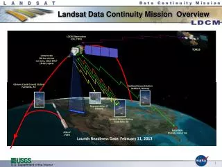
Landsat Data Continuity Mission (LDCM) USGS Project Status Report. March 1, 2011 Dave Hair - USGS LDCM Project Manager (acting) Doug Daniels - Integration Lead, The Aerospace Corporation. Agenda. USGS LDCM Project Team Update Ground Systems (GS) Overview Scope and Roles & Responsibilities

E N D
Landsat Data Continuity Mission (LDCM)USGS Project Status Report March 1, 2011 Dave Hair - USGS LDCM Project Manager (acting) Doug Daniels - Integration Lead, The Aerospace Corporation
Agenda • USGS LDCM Project Team Update • Ground Systems (GS) Overview • Scope and Roles & Responsibilities • Review Status and Schedule • Architecture • External Interfaces • Technical Performance Metrics • Ground Readiness Tests • Ground Network Element • Collection Activity Planning Element • Data Processing and Archive Element • Calibration and Validation • International Cooperator • Operations Concept and Architecture
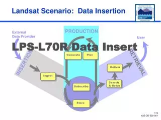
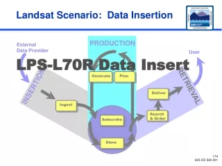
USGS LDCM Scope Ground System Development • Ground Network Element (GNE) • Antenna & associated equipment for X-Band image & S- • Band telemetry data downlink reception and generation of • S-Band command uplink • Collection Activity Planning Element (CAPE) • Generates high level imaging mission schedules • Mission Operations Element (MOE) • Provides mission planning & scheduling, command & • control, monitoring and analysis, flight dynamics & • onboard memory management • Data Processing & Archive System (DPAS) • Ingests and generates L0Ra data from GNE-provided Mission data • Stores and archives LDCM data (Mission, L0Ra, and product) • Provides inventory and metrics database services • Provides Product Generation, Image Assessment, & Subsetter • Provides web interface to facilitate: data discovery, product selection & ordering (for Cal/Val), & product distribution • Science • Co-chair the Landsat Science Team (LST) • Conduct research and define product requirements • Develop algorithms to be used for the radiometric and • geometric characterization, calibration, and processing • Develop the Cal/Val Toolkit (CVTK) • Perform verification and refinement of the Long Term • Acquisition Plan (LTAP) • Communicate with and characterize the user community • Operations Transition • Transition to Landsat Operations – a separate project • Define operational transition strategy • Ensure operations requirements are fully accounted & represented • Liaison with International Cooperators • Support test procedure development, execution, and reporting • Develop Standard Operating Procedures (SOPs) • Develop and provide operations training • Capital Planning & Investment Control (CPIC) • Department of Interior/USGS investment – Land Satellites Data System (LSDS) • Exhibit 300 for LSDS Investment 6
Other R&Rs • Ground System (GS) Engineering • NASA leads • USGS provides substantial support • GS Integration & Test (I&T) • NASA and USGS co-lead Ground Readiness Test (GRT) Team • NASA leads Mission Operations Center (MOC) GRTs (1, 2, 3, 5, 6) • UGSS leads Data Processing and Archive System (DPAS) GRTs (4a, 4b, 4c) • Facilities, IT Security • NASA leads facilities integration and IT Security for MOC. • Some cost of MOC network equipment is shared with USGS. • USGS leads facilities integration and IT Security for Ground Network Element (GNE) and DPAS • Cal/Val • NASA leads pre-launch through declaration of Initial Operating Capability (IOC) • USGS leads nominal ops through decommissioning • Operations • NASA leads pre-launch through IOC • USGS leads nominal ops through decommissioning. • USGS funds bulk of FOT costs both pre- and post-launch.
GS Technical Performance Measures • Ground System performance is monitored through a set of TPMs • To support management of the development process between milestone reviews • Design is not static • TPMs are monitored on a regular basis
Ground Readiness Test (GRT) Status *TIRS Simulator to be integrated at MOC in summer 2011, GS testing will be completed then. Italicized text = completed
Key GNE Functions • S-Band Telemetry & Command Communications with Observatory • X-Band Data and telemetry reception from Observatory • Low Density Parity Code and CCSDS Processing of Received X-Band data and stored state of health telemetry • CSSDS File Data Protocol processing to verify data integrity and extract mission data • Close CFDP accounting handshake loop for Solid State Recorder Management • Transfer mission data files to Data Processing and Archive System (DPAS) for archive, processing, and product generation • Hold 90-day cache of mission data files at LGN station for disaster recovery
LGN Design Approach LDCM Ground Network (LGN) Partnerships to use existing stations currently supporting Landsat NOAA Interagency Agreement (IA) to use Gilmore Creek Station (GLC) near Fairbanks, AK Landsat Ground Station (LGS) at USGS/EROS near Sioux Falls, SD NASA contract with KSAT for Svalbard; options for operational use by USGS Provides ≥ 200 minutes of Contact Time Common Avtec Programmable Demods LDPC Forward Error Correction and CCSDS/CFDP Processing and Data Capture Landsat Scalable Integrated Multi-mission Simulator System (LSIMSS) Used for T&C Processing at LGN Stations Transfer of Station Status to MOE Used for MOE and S/C testing
GNE Development Status • GNE Build 1 completed • Currently in operational use at LGS • GNE Build 2 (LGS station plus Data Routing & Capture System) completed • GNE Build 3 (adds GLC station) • LDCM Equipment Integrated in New GLC Building • Final Cabling to NOAA 13m Antenna System • DCRS 2.0, New Network, and Failover Router Installed • LDCM Equipment Integrated with GLC Epoch-2000 Station Controller • On Schedule to Complete in April 2011 • GNE Build 4 (adds SGS station) • KSAT TRR for Antenna, S-Band, and X-Band tests held in February 2011 • Testing completed (both antennas) • KSAT on schedule to complete Level 5 testing • GNE Build 4 Level 4 testing occurs in March • Planned for completion in early April
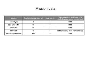
Long Term Acquisition Plan • The Long Term Acquisition Plan (LTAP) defines the OLI and TIRS data collection strategy for LDCM. • Optimize data collection capacity of 400 scenes per day out of 800+ land scenes viewed • The Collection Activity and Planning Element (CAPE) executes the LTAP • The Mission Operations element (MOE) is responsible for incorporating the data collections defined by the LTAP with other observatory events and creates the entire schedule that is uploaded to the observatory
LTAP Parameters • Historical cloud climatology • Seasonality • Begin / End date, Acquire once / always, Base priority values for land, islands, conterminous U.S. • Priority schema for non-LTAP data collection requests • Solar zenith angle constraints • Cloud cover predictions (NCEP) • Automated cloud cover assessments (DPAS ) • User requests (DPAS) • Observatory maneuvers, health and safety, observatory resources, and collection of calibration data (MOE)
LTAP 7 to 8 Functional Continuity Observatory MOE Reconcile priorities with observatory resources GNE Science Office Scheduling OLI & TIRS Data acquisition LTAP science parameters DPAS Collection Planning CAPE Data collection requests OLI & TIRS data processing Cloud cover assessments Iterative modeling of inputs and decision rules NCEP Cloud cover predictions All LTAP-7 functionality is captured within the CAPE capabilities
Collection Activity Planning Element • The CAPE executes the LTAP • De-conflicts external scene requests • Determines cloud avoidance • Provides de-conflicted scene list to Mission Operations Element • CAPE design build on GOTS P&S software • SAIC Mission Planning System (MPS) • Open design with SOA-compliant interfaces
Architecture Key Points • Re-uses proven Government-Off-The-Shelf (GOTS) software for ‘Core’ Components • Reduces risk and cost • Implements common, fully functional Planning & Scheduling software • Mission Planning Systems updated where needed • Wrapped to be Service Oriented Architecture (SOA) compliant • Schedule Engine updated to use LDCM unique scheduling algorithms • New Development for ‘Interface’ components • New components for each external interface • LDCM-unique capabilities • Designed/developed to be SOA compliant from beginning • Communication with MPS components mostly through database
Architecture Key Points (cont) • Service Oriented Architecture (SOA) Compliant • Conform to industry SOA standards (SOAP, WSDL, XML, etc.) • Runs on top of Infrastructure Element Service Framework • Allows for interaction with different types of systems • Components are loosely coupled, highly cohesive • Simple messages between components • Data exchanged through database • Minimal changes needed to existing GOTS used to implement portions of CAPE • Components can be swapped out without change to remaining components • Interfaces are database dependent • New components must conform to existing interfaces • ‘Open’ design • Can add resources (observatories, sensors, etc) without recompiling • Expansible functionality • Works with multiple schedule engines
CAPE Status • CAPE Builds through 1.3 resident within the MOC • CAPE 2.0 Testing complete • Test Readiness Review (TRR) held earlier than planned - February 2011 • Test participation by Flight Operations Team (FOT) and USGS Data Acquisition Manager (DAM) • Delivery needed for GRT 6 • On Track for Delivery on 3/11/11 or Sooner • Level 4 testing highly successful • CAPE 3.0 close-out release planned • Work on CAPE 3.0 to starting March 2011 • Contains enhancements to support additional modeling • DAM providing input on CAPE 3.0 modeling capability definition
DPAS Development Status • DPAS 1.0 Progress (supports GRT 4a – Safeguard Mission Data) • All subsystems required for DPAS Build 1.0 have been delivered! • Storage and Archive R2.0: February 10th PSR • Ingest R1.0: February 17th PSR • Inventory R1.1: February 17th PSR • Subsetter R1.0: February 17th PSR • User Portal R1.0: November 19th PSR – previously delivered • Test and operations environment complete (excepting operational disk storage) • DPAS Build 1.0 currently on schedule to meet April 2011 delivery • Performing dry runs of Build 1.0 test procedures – going well • Successful first test of actual GNE/DPAS interface (DCRS-Ingest) • Test Readiness Review: February 28th • Pre-Ship Review: March 30th • DPAS 2.0 Progress (supports GRT 4b - Level 1 Processing) • Received all algorithms needed to generate L1 products • Demonstrated capability to manually generate a L1T product (next slide) • Image Assessment System (IAS) R1.0 algorithm development finishing this month • Focus in March will be software component integration
DPAS Development Status • DPAS 3.0 supports GRT 4c (full production) • DPAS 4.0 (post-launch closeout release) • Keeping in sync with S/C while maintaining schedule is becoming increasingly challenging • Working with Orbital to understand ancillary data format • “Epoch” approach to data definition allows DPAS development to align with spacecraft at specific times in development • Epoch 1 format is the current baseline; governs format for DPAS Build 1 and GRT 4a • Epoch 2 format is defined by the output of the Orbital raw CADU test • EROS engineers were on hand to observe test and returned with output data • DPAS engineering team is nearly finished analyzing this data • Epoch 2 definition nearly complete • DPAS team successfully ingested Epoch 2 format last week!! • TIRS ancillary data not finalized yet
Calibration & Validation Functions • Oversight and coordination of Cal/Val activities • Covers portions of ground system, spacecraft, instrument and other external entities • USGS Robotic Lunar Observatory (ROLO) • Algorithm development • OLI data simulator • For algorithm testing only • Cal/Val ToolKit (CVTK) • Algorithms delivered to DPAS developers • Data processing, characterization and calibration • Instrument performance characterization • Pre-launch, OIV and on-orbit operations • Supports instrument acceptance
Calibration & Validation Functions • Calibration parameter determination & validation • Pre-commissioning validation of vendor provided parameters • Validated parameters ensure quality products • Determine parameters during operations • Product performance characterization • Reports for science and user community • Independent calibration verification and calibration continuity • Ensures traceability and continuity with historical products • Anomaly resolution • Includes anomalies in product generation and image assessment • Supports observatory and other anomaly resolution, as requested by FOT
Cal/Val Status • OLI Instrument Performance Assessment • Completed OLI Flight Unit spectral (and radiometric) testing support • Conducted independent performance analyses and reviewed Ball preliminary analyses • OLI exceeding large majority of requirements examined to date • Reviewed OLI verification reports with discussions in Cal/Val working group (a few completed, many more coming) • TIRS Instrument Performance Testing • Reviewed TIRS performance test procedures and test narratives (a few completed, more coming) • Image Processing Algorithms • Updated several geometric algorithm to include jitter correction • TIRS Image Simulator • Clarified TIRS Simulator input format to enable TIRS simulated imagery (from the reprojection tool, which reprojects Landsat-7 precision-terrain products to TIRS L0Rp format) to be input to the TIRS Simulator so end-to-end testing of TIRS imagery can be performed
International Operations • LDCM will provide a direct, real-time downlink as the primary data delivery mechanism with bilateral data exchange capabilities (electronic primary, media secondary) • Image Requests & Collection • ICs submit data collection requests through the Landsat Mission Web Site (LMWS) IC Web Portal (part of the User Portal) • User Portal (UP) updates the Collection Activity Planning Element (CAPE) instrument scheduling tool • CAPE generates an optimal image collection schedule based on the global science acquisition strategy, IC requests, Cal/Val requests, other special requests, along with cloud cover predictions, and provides collection schedule to the Mission Operations Element (MOE) for uplink to the Observatory • Downlink provided via Earth coverage X-band antenna • Real-time data also stored on-board for downlink to an LGN station
International Operations (cont) • Information & Data Exchange • Provide scheduling and communication products • Provide bilateral Data Validation & Exchange (DV&E) • Includes bilateral mission data exchange • Includes bilateral mission and L1T product data validation • Includes metadata and browse exchange • Provide ancillary data (e.g. CPF, BPF) • Provide documentation and software for mission data ingest and science data processing (ITAR approval obtained) • Landsat Technical Working Group (LTWG) #20 in Sioux Falls (May 23-27, 2011) • Offering additional technical workshop focusing on Landsat and LDCM science data reception and processing capabilities
Other IC Activities • GLS1990/GLS2010 • Requesting mission data from ICs for GLS1990 reprocessing • GLS2010 acquisitions extended through CY2011 • Mid-campaign GLS2010 metadata/browse requested and received • LGAC • Brazil, Canada, Indonesia, Puerto Rico actively exchanging data • Argentina, Australia, Ecuador, Japan (HIT), South Africa will be soon • China, ESA, Japan (RESTEC), Thailand in agreement negotiations • Investigating technical data issues with India • Participation difficulties remain with Pakistan and Saudi Arabia • L8 IC Agreements • State Department approval of multi-mission framework agreement (September 2010) • Initiated IC review and approval at LGSOWG#39 (October 2010) • Australia and South Africa generated 1st L1T products from USGS LPGS
Summary • Ground Readiness Tests underway • Making excellent progress verifying critical mission operations functionality • Significant progress on ground system software, hardware, and infrastructure • Ground Network Element – LGS complete with SGS and GLC underway • Collection Activity Planning Element – Initial capability fully tested with Build 2 arriving in March • Data Processing and Archive System – Build 1 coming in April and successfully ingested Epoch 2 data (based upon S/C CADU) • Cal/Val instrument performance assessments • OLI exceeding majority of performance requirements examined to date • Reviewing TIRS performance test procedures
MOE Schedule Status • Patch 3.3.5 for GRT3 expected 2/28/11 • Build 4.0 PSR (for MRT1) delayed from 3/10 to 4/26 • No reserve remaining – watching closely • Evaluating any patch fixes needed from B4.0 prior to GRT5 • MOE tentatively planning for 3-month patch schedule • Will likely want patch prior to GRT6a • Will still address emergency patches, as needed