Download
1 / 21
220 likes | 347 Vues
Forecasting Thunderstorms in Terminal Aerodrome Forecasts (TAFs) Some new insights. Steven Thompson National Weather Service (NWS) La Crosse, WI. Purpose Identify ways to improve TAF thunderstorm forecasts to:. Reduce false alarm (FA) hours. Increase efficiency of airport operations.

E N D
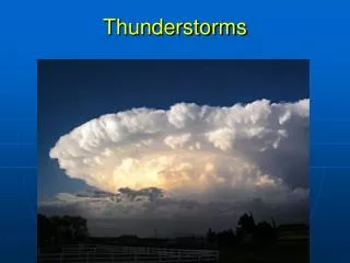
Forecasting Thunderstorms in Terminal Aerodrome Forecasts (TAFs)Some new insights Steven Thompson National Weather Service (NWS) La Crosse, WI
PurposeIdentify ways to improve TAF thunderstorm forecasts to: • Reduce false alarm (FA) hours. • Increase efficiency of airport operations. • Enhance aviation safety. • Promote credibility of NWS aviation products.
NWS TAF FM1200 18012KT P6SM SCT040 TEMPO 2024 3SM –TSRA BKN020CB FM0000 20012KT P6SM BKN030 TEMPO 0004 VRB38G55KT 1SM +TSRAGR BKN010CB FM0400 21010KT P6SM BKN040 PROB30 0408 3SM –TSRA BKN020CB FM0800 24014KT 6SM HZ OVC030 PROB30 0812 2SM TSRA BKN015CB= Where are all of the thunderstorms they forecast?
MethodologyPrimary data sources were: • Aviation Verify program. • Aviation verification statistics. • Solar and Meteorological Surface Observation Network, 1961-1990.
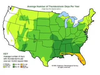
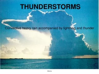
Thunderstorm ClimatologyApril-September, 1961-1990 Hourly observations with a thunderstorm (TS) reported at La Crosse, WI (LSE) and Rochester, MN (RST).
Thunderstorm Climatology April-September, 1961-1990 Percentage of hourly observations with and without TS at LSE and RST.
PROB TS hours verified April-September 2003NWS Central Region TAFs
PROB TS hours vs. hours verified April-September 2003NWS Central Region TAFs
How can we improve TS forecasts in TAFs?Here’s what the La Crosse NWS forecasters said: • Limit PROB and TEMPO groups beyond 8 to 12 hours. • Limit time length of PROB and TEMPO, i.e. ≤ 2 hours. • Eliminate forecast of thunderstorms beyond 12 hours. • Use vicinity thunderstorm (VCTS) or cumulonimbus (CB) in lieu of TEMPO and PROB groups. • Keep in mind climatology, i.e. time of day, month. • Only use TEMPO for categorical events. • Key on organizedversus unorganized convection.
“Funnel effect” philosophy of forecasting TS in TAFs Organized convection ≥50% probability of occurrence Unorganized convection <50% probability of occurrence Uncertainty 24 hrs TEMPO? VCTS? CB? CB? No TS? TAF valid time VCTS PROB30 TEMPO VCTS 0 hr PREVAILING,TEMPO
Forecast scenarios • Capped summer environment with a small chance of breaking the cap in the late afternoon/evening. The recommended TAF would be: At 18-24hrs, with model guidance consistently indicating a strong cap? FM1800 18010KT P6SM SCT040 FM0300 18010KT P6SM SCT250= At 3-6hrs, with nothing currently on radar? FM1800 18010KT P6SM SCT040 FM0300 18010KT P6SM SCT250=
Forecast scenarios • TS possible, but will probably be scattered. There is a 30 percent chance of TS in the forecast grid database. The recommended TAF would be: At 18-24hrs, with models indicating unorganized convection? FM2100 18012KT P6SM BKN040CB FM0300 18012KT P6SM SCT250= At 3-6hrs, with scattered thunderstorms currently on radar? FM2100 18012KT P6SM VCTS BKN040CB FM0300 18012KT P6SM SCT250=
Forecast scenarios • Cold front moving into an unstable atmosphere and there is wind shear to support organized convection along a squall line. The recommended TAF would be: At 18-24hrs, with model timing of cold front 22Z-00Z? FM1800 20014G22KT P6SM BKN040 FM2200 20014KT P6SM VCTS BKN040CB TEMPO 2224 VRB20G35KT 2SM SHRA BKN020CB FM0000 31014KT P6SM SCT250= At 4-6hrs, with an actual squall line approaching ? FM1800 20014G22KT P6SM BKN040 FM2200 20014KT P6SM VCTS BKN040CB TEMPO 2224 VRB20G35KT 2SM TSRA BKN015CB FM0000 31014KT P6SM SCT250=
Forecast scenarios • Mesoscale Convective System (MCS) and moisture transport maximum support organized convection in your forecast area. The recommended TAF would be: At 20-24hrs, with model guidance indicating potential MCS ? FM0600 18015G23KT P6SM BKN250 FM0800 16015G23KT 4SM –SHRA BR VCTS OVC040CB TEMPO 0812 2SM SHRA BR BKN020CB= At 2-6hrs, with an actual MCS approaching? FM0600 18015G23KT P6SM BKN250 FM0800 16015G23KT 4SM –TSRA BR OVC040CB TEMPO 0812 2SM TSRA BR BKN020CB…
CAUTION!! • There is no “silver bullet” when forecasting thunderstorms in TAFs. • A higher level of TAF preparation and monitoring is required to utilize insights suggested in this presentation. • Probability of detection (POD) may suffer at the expense of reducing false alarm hours.
TAF FA hours vs. PODApril-September NWS La Crosse TAFs (0-12hr forecast) TAF FA hours were reduced 71%, but POD dropped 64 %.
TAF PROB TS hours vs. TAF FA hoursApril-September NWS La Crosse TAFs (0-24hr forecast) PROB hours were reduced 92%, with FA hours reduced 74 %.
ConclusionsHow can we improve TS forecasts in TAFs? • Limit PROB and TEMPO groups beyond 8 to 12 hours. • Limit time length of PROB and TEMPO, i.e. ≤ 2 hours. • Eliminate forecast of thunderstorms beyond 12 hours. • Use VCTS or CB in lieu of TEMPO and PROB groups. • Keep in mind climatology, i.e. time of day, month. • Only use TEMPO during categorical events. • Key on organized versus unorganized convection.
Acknowledgments • Dan Baumgardt, Science and Operations Officer, NWS La Crosse, WI for much appreciated assistance in data assimilation and critique of this presentation.
Forecasting Thunderstorms in Terminal Aerodrome Forecasts (TAFs)Some new insights Steven Thompson National Weather Service (NWS) La Crosse, WI