Image Classification
Image Classification. Digital Image Processing Techniques. Image Restoration Image Enhancement Image Classification. Image Classification: the art and science of using the computer to interpret the image. Why do it?.
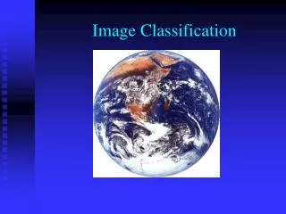

Image Classification
E N D
Presentation Transcript
Digital Image Processing Techniques • Image Restoration • Image Enhancement • Image Classification
Image Classification: the art and science of using the computer to interpret the image. Why do it?
Especially when automated computer methods oppose a long “proven” history of visual/manualimageinterpretation
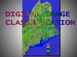
However, with image classification you can make cool looking maps with more spatial detail than humans would ever draw!
Coop Project with Cal Fish and Game 15-meter Landsat7 Pan Sharpened Imagery Modified CWHR Classification
Semi-automatedchange detection A Combination of supervised image classification, polygon formation and visual editing of resulting polygons proves useful for forest monitoring.
Semi-Automated Change Detection Based upon 5km by 5km Blocks of Satellite Imagery
Image to Image Registration Accomplished with SPEAR tools In ENVI
The multi-date stacked image allows creation of two-date color composites that allow the visual identification of change
ENVI EX used to classify the image block into four classes: Forest (unchanged) Non-Forest (unchanged) Deforestation (forest changed to non-forest) Reforestation (non-forest changed to forest)
Training areas defined for all spectral classes visible in the image
Objectives: • Understand the principle of supervised classification including definition of classes and selection of training areas • Describe the maximum likelihood classification algorithm, the one most often used.
Image Classification • Supervised • Training stage - analyst determines source identity • Classification stage • Output stage
Supervised Classification Select Training Areas Edit/ Evaluate Signatures Classify Image Evaluate Classification Subjective human influence selects “representative samples” of all land cover types required for the analysis < 5% of the pixels used for training. Subjective human judgment resolves problems: spectral signatures not separable, or spectral signatures redundant. Unbiased machine determines the class into which the unknown pixels are assigned (>95 % of the pixels are unknown before classification). Again subjective humans evaluate results and define new classes to change things as they desire.
1 2 3 4 5 6 7 1 2 3 4 5 6 7 1 2 3 4 5 6 7 1 2 3 4 5 6 7 1 2 3 4 5 6 7 1 2 3 4 5 6 7 Water Sand Forest Urban Corn Hay Classification Based on Spectral Signatures • Spectral response measurements (spectral signatures) recorded across 7 Landsat TM bands: 1, blue; 2, green; 3, red; 4 & 5, VNIR; 6, TIR and 7, SWIR Adapted from Lillesand and Kiefer, 1999
F F F F F F F F S F F F U F F F W S F F U U F F C W W S U U U C C S W S U U C C C 3 2 4 4 2 5 1 2 S W W S S S C C 2 4 5 6 2 3 1 2 F S W W W S C C 1 2 5 3 1 2 3 6 F F S S W W S C 6 5 4 3 3 5 2 3 5 3 3 5 4 2 3 2 6 4 4 5 2 3 3 5 1 4 2 3 3 6 2 4 2 3 5 2 3 3 5 2 Supervised Classification Water Urban Forest Corn Hay Sand • Training Stage • create classes Classification Stage compare unknown pixels to known spectral “signatures” • Output Stage • typically, a color-coded map • identify training areas of uniform class land cover • assign to most similar Adapted from Lillesand and Kiefer, 1999
Traditional way to view spectral signatures. red visible urban sand very near IR hay water corn forest BAND 3 BAND 4
S U S S U U S S S U U U U S U S U U U U U U U U C C U C U U U U C C U U C U C U C C U 3 2 1 H C U U C U C H H H H H U H H H H H H H H H H H H H H H H H H H H F W F H F F F F W W F F F W F F F W W F F F F W W F F F F F W W F F W W F F W Supervised Classification Stage urban sand • Two-band scatter diagram showing spectral separability of different land covers corn Band 3 Digital Number Determine land cover class of each pixel in the scene hay water forest Band 4 Digital Number Adapted from Lillesand and Kiefer
S U S S U U S S S U U U U S U S U U U U U U U U C C U C U U U U C C U U C U C U C C U 3 1 2 H C U U C U C H H H H H U H Band 3 Digital Number H H H H H H H H H H H H H H H H H H H F W F H F F F F W W F F F W F F F W W F F F F W W F F F F F W W F F W W F F W Band 4 Digital Number Supervised Classification -Maximum Likelihood Classifier Gaussian probability function computed for each pixel for each class Pixel assigned to class for which its probability of membership is the greatest. Can be limited to some number of standard deviations or probability threshold. Adapted from Lillesand and Kiefer
Pixels as classified by ground truth Classification accuracy from user’s view if computer classified a pixel as urban, how accurate was that classification? 629/689=91%…9% Error of Commission Pixels as classified by the computer Correctly classified pixels Classification accuracy from producer’s view… how many of the known urban pixels were classified by the computer as urban? 629/702=90%…10% Error of Omission Overall Accuracy = 1033+629+385 +319+20/2578 = 93% Classification - Error Matrix