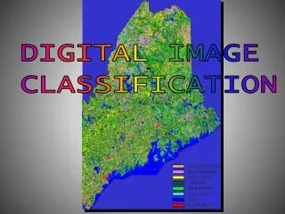
DIGITAL IMAGE CLASSIFICATION
DIGITAL IMAGE CLASSIFICATION. Digital Image Processing. Image Classification (for land cover mapping) Objective: Replace visual image data with quantitative techniques for automated identification of objects. A. Training class selection or clustering

DIGITAL IMAGE CLASSIFICATION
E N D
Presentation Transcript
DIGITAL IMAGE CLASSIFICATION
Digital Image Processing Image Classification (for land cover mapping) Objective: Replace visual image data with quantitative techniques for automated identification of objects. A. Training class selection or clustering B. Generation of statistical parameters C. Data classification approach ( supervised or unsupervised) D. Classification evaluation and refinement E. Accuracy Assessment /Documentation
Image (Land Cover) Classification Two Methods • Common classification procedures can be broken down into two broad subdivisions based on the method used: • We create an unsupervised classification when the computer separates features solely on their spectral properties and • a supervised classification when we use some prior or acquired knowledge of the classes in a scene in setting up training sites to estimate and identify the spectral characteristics of each cover type class.
Image ClassificationUnsupervised Approach • reverses the supervised classification process: Spectral classes are grouped or clustered first by the computer program, based solely on the numerical information in the data, and are then matched by the analyst to information classes (land cover) as best as possible).
Image ClassificationSupervised vs. Unsupervised • unsupervised classification is not completely without human intervention (knowledge of the cover types; ground truthing). However, it does not start with a pre-determined set of cover type classes as in a supervised classification. • some of the spectral patterns of unsupervised clusters do well in singling out some of the features in an image. But, many individual areas represented by clusters may not to correlate with what you thought was on the ground (e.g. problems with “artificial division” of spectral responses, “mixed pixels”, etc.)
Image ClassificationSupervised vs. Unsupervised • in a supervised classification we are first identifying the information classes which are then used to determine the spectral classes which represent them. • Supervised classification is more accurate for mapping classes, but depends heavily on the knowledge and interpretation skills of the image analyst. • Also depends on having adequate ground or reference data to be used as training sites (e.g. problems with remote and inaccessible areas)
Digital image classification techniques use radiance • measured by a remote sensor in one or more wavebands • to sort pixels into information classes or themes. • end result is a thematic map Digital image classification: • During visual image interpretation, you are continually sorting pixels into homogeneous areas that you associate with land cover features of interest. • You are essentially classifying image data using elements • of visual interpretation – tone (relative brightness), texture • (tonal variation), shape, size, pattern…)
Image (Land Cover) Classification Two Methods • Common classification procedures can be broken down into two broad categories: • unsupervised classification (Lab 8) • The computer separates features solely on their spectral properties – computer groups pixels into spectral classes • Analyst subsequently groups spectral classes into information classes (e.g., land cover types) • supervised classification(Lab 9) • Analyst uses prior knowledge of information classes to establish training sites, used to identify the spectral characteristics of those information classes • The computer then assigns each pixel into an information class according to its spectral characteristics
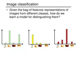
Spectral classes: Groups of pixels that are spectrally uniform or near-uniform -pixels that show similar brightness in the different wavebands for similar earth surface features. Information classes: Categories of interest (e.g. land cover classes such as forest, wetland, etc.) The objective of image classification is to match spectral classes to information classes.
Unsupervised Classification Iterative Self-Organizing Data Analysis Technique (ISODATA) Analyst sets the number of classes (e.g, 45), the number of iterations (e.g., 100) and the convergence threshold (e.g. .995). The # iterations and conv. threshold tells the ISODATA program when to quit. 1st iteration
Unsupervised Classification Iterative Self-Organizing Data Analysis Technique (ISODATA) 2nd iteration
Unsupervised Classification Iterative Self-Organizing Data Analysis Technique (ISODATA) 3rd iteration
Unsupervised Classification Iterative Self-Organizing Data Analysis Technique (ISODATA) ISODATA generating spectral classes (clusters) going into a statistical file – multivariate stats (mean, S.D., corr. matrix, co-var. matrix) in n-band space.