GEOGRAPHY TERMS
GEOGRAPHY TERMS. What are the four main points on a compass rose? cardinal directions. GEOGRAPHY TERMS. This is a term used to describe heights on a map. elevation. GEOGRAPHY TERMS. This is found at 0° degrees south. equator. GEOGRAPHY TERMS.

GEOGRAPHY TERMS
E N D
Presentation Transcript
GEOGRAPHY TERMS What are the four main points on a compass rose? cardinal directions
GEOGRAPHY TERMS This is a term used to describe heights on a map. elevation
GEOGRAPHY TERMS This is found at 0° degrees south. equator
GEOGRAPHY TERMS What is found at about 23° degrees north of the equator? Tropic of Cancer
GEOGRAPHY TERMS This is found at 180° degrees longitude. International Date Line
GEOGRAPHY TERMS What is half of a sphere? hemisphere
GEOGRAPHY TERMS This is another name for longitude lines. meridians
GEOGRAPHY TERMS These lines are found east or west of the Prime Meridian. Lines of longitude
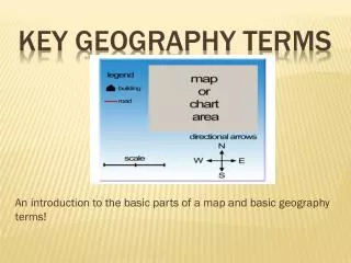
GEOGRAPHY TERMS What shows the relationship between distance on a map and real distances on the earth’s surface? scale
GEOGRAPHY TERMS What is found at 0° degrees longitude? Prime Meridian
GEOGRAPHY TERMS This is found at about 90° degrees north. North Pole
GEOGRAPHY TERMS A direction indicator usually found in the corner of a map. compass rose
GEOGRAPHY TERMS The imaginary boundary of the North Polar Region. Arctic Circle
GEOGRAPHY TERMS What is located at about 23° degrees south of the equator? Tropic of Capricorn
GEOGRAPHY TERMS This is another name for latitude lines. Parallel lines
GEOGRAPHY TERMS Lines that are found north or south of the equator. Lines of latitude
GEOGRAPHY TERMS What is the imaginary boundary of the South Polar Region? Antarctic Circle
GEOGRAPHY TERMS What is at 0° degrees elevation? sea level
GEOGRAPHY TERMS What is found at about 90° degrees south? South Pole
GEOGRAPHY TERMS A network of intersecting lines. grid
GEOGRAPHY TERMS What are the four main points on a compass rose? cardinal directions This is a term used to describe heights on a map. elevation This is found at 0° degrees south. equator What is found at about 23° degrees north of the equator? Tropic of Cancer This is found at 180° degrees longitude. International Date Line What is half of a sphere? hemisphere This is another name for longitude lines. meridians These lines are found east or west of the Prime Meridian. Lines of longitude What shows the relationship between distance on a map and real distances on the earth’s surface? Scale What is found at 0° degrees longitude? Prime Meridian This is found at about 90° degrees north. North Pole A direction indicator usually found in the corner of a map. compass rose The imaginary boundary of the North Polar Region. Arctic Circle What is located at about 23° degrees south of the equator? Tropic of Capricorn This is another name for latitude lines. Parallel lines Lines that are found north or south of the equator. Lines of latitude What is the imaginary boundary of the South Polar Region? Antarctic Circle What is at 0° degrees elevation? sea level What is found at about 90° degrees south? South Pole A network of intersecting lines. Grid