Download
1 / 20
200 likes | 223 Vues
Explore the dynamics of seabreeze formation along the New Jersey Shore, including prediction methods and case studies. Discover the significance of forecasting for coastal safety, energy costs, thunderstorms, and aviation hazards. Dive into advanced models like CODAR, RAMS, and COAMPS for accurate mesoscale predictions and future research prospects.

E N D
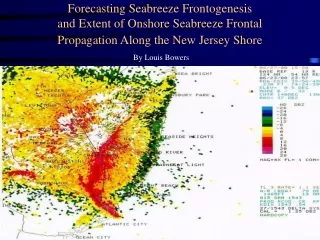
Forecasting Seabreeze Frontogenesis and Extent of Onshore Seabreeze Frontal Propagation Along the New Jersey Shore By Louis Bowers
Outline • What exactly is a “seabreeze”? • How are seabreezes predicted? What determines the extent of seabreeze frontal propagation? • Case Study
What is a Seabreeze? • Seabreeze: a mesoscale phenomenon that is the result of a • complex ocean/atmosphere interaction during the late • Spring and Summer months. • It occurs due to the differential heating rates of the ocean and the land. • To maintain continuity, as the air over the • land rises, air moves onshore from over the ocean to replace it. • A Seabreeze frontal boundary is formed where the cool, moist marine air meets the warm, dry continental air.
Why Do We Need to Predict Seabreezes? • More accurate forecasts along coastal sections for beachgoers. • Cost to electric companies - Cost of $250,000 for every degree temp forecast error per hour. (GPU Energy) • Better forecasts for seabreeze induced thunderstorms - risk of flash flooding. • Aviation hazard - seabreezes create low-level wind shear which may impact small commuter aircraft.
How are seabreezes predicted? • Forecasting mesoscale phenomena requires using mesoscale resolution methods. • CODAR • Mesoscale Numerical Weather Prediction Models • -Regional Atmospheric Modeling System • (RAMS) - Colorado State University • -Coupled Ocean Atmosphere Modeling System • (COAMPS) - US Navy
Seabreezes and CODAR • CODAR may act as a short term predictor of seabreeze frontogenesis offshore. • Detided CODAR: effect of wind stress on the ocean currents. • Distance from offshore extent of the circulation to coastline = distance from coastline to the seabreeze front -----> Extent of Onshore Propagation.
Case Study: July 9, 2000 • RAMS • COAMPS • Radar
RAMS • 4 Km Resolution • Internal Soil Moisture model to initialize surface heat fluxes. • Model run out to 72 hours - forecasts made for every 30 mins. • Products available include: Temp, Pressure, Winds, and RH..
COAMPS • 27 Km Resolution. • Model run every 12 hours - forecasts made for 48 hours. • Products include: Temp, Pressure, Winds, and Relative Humidity.
Future Seabreeze Research at Tuckerton • SODAR: Provides vertical profiles of horizontal and vertical winds, as well as temperature. • Long-range CODAR: Extention include the entire NJ shoreline from Sandy Hook to Cape May, and greater offshore coverage. • Enhanced resolution COAMPS model.
Concluding Statements • The forecasting of mesoscale features such as seabreezes are the future of operational and research meteorology. • Accurate short-term prediction (~1-2 days) of seabreezes will be available within a few years. • Thank you very much for your time and attention. • Special thanks go to my mentor for this project, Dr. Scott Glenn, and all the people I worked with at Tuckerton and NWS.