Measuring Direction
Understand how to measure direction, latitude, and longitude, recognize different types of marks and signals, and interpret chart scales for precise navigation on water. Learn the 3-R Rule, buoy and beacon identification, and essential navigation definitions.
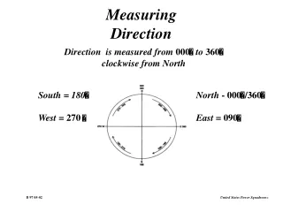

Measuring Direction
E N D
Presentation Transcript
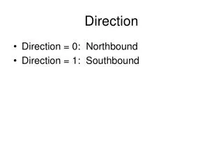
Measuring Direction Direction is measured from 000 to 360 clockwise from North South = 180 West = 270 North - 000/360 East = 090 B 97 05-02
LATITUDE B 97 05-04
Longitude B 97 05-05
Measuring Latitude and Longitude One minute of latitude equals one nautical mile B 97 05-06
HOW CHART SCALESDIFFER B 97 05-07-1
CHART SCALES Small Scale chart Large Scale Chart Small scale charts show large areas Large scale charts show small areas B 97 05-08
CHART SCALES B 97 05-07-2
“MARK”AN AID TO NAVIGATION YOU SEE WHILE BOATING TWO CATEGORIES OF MARKS • Lateral Marks • Marks starboard and port sides of a route • Non-Lateral Marks • Supplemental aids having no lateral significance BS 98 03-01 - B 97 06-01
IDENTIFICATION OF “MARKS” • In Daylight • Shapes • Colors • Numbers or letters • Sounds • At Night • Light color and patterns • Sounds Always Locate Marks On Your Chart BS 98 03-02 - B 97 06-02
TYPES OF “MARKS” • BUOYS • Floating marks anchored at specific locations • BEACONS • Fixed marks permanently fastened to the earth’s surface BS 98 03-03-1 - B 97 06-03
“BUOYS” • Floating Aids • Various shapes and colors • Position approximate • Identified by • Number, letters, sound devices and lights • Chart symbol • diamond with a small position circle • Magenta disc around position circle, if lighted BS 98 03-03-2 - B 97 06-04
“BEACONS” • Permanently fixed to Earth's surface • Examples: • Lighthouses • Daybeacons • Identified by: • Numbers, letters, sound devices, lights • Chart symbols: • Unlighted - small triangle or square • Lighted - magenta flare with a black position dot BS 98 03-03-3 - B 97 06-05
The “3-R” Rule Red - Right - Returning • When Returning from sea, keep red side-of-channel marks to your starboard • “Returning” is: • Entering a harbor or bay from the open ocean • Traveling up a river from the sea • Traveling clockwise around the U.S. along it’s coastline • South along the Atlantic coast • West along the Gulf coast • North along the Pacific coast BS 98 03-05 - B 97 06-06
TYPES OFSOUND SIGNALS BS 98 03-11 - B 97 06-08
Definitions • Navigation • The science of directing the movements of a boat from one place to another in a safe and efficient manner. • Piloting • A part of navigation using landmarks, navigational aids, and soundings as primary tools. B 97 07-01
A Chart Compass Rose Variation is found in the center of the compass rose B 97 07-03