Area: 216 km 2
150 likes | 315 Vues
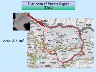
Pilot Area of Veneto Region (Italy). Area: 216 km 2. soil map 1:250.000 of Veneto Region. Pilot area INSPIRE GRID. SOIL MAP 1:250.000 rastered by 10 m pixels GRID 1 km. 10 m pixel in order to have only 1 SMU value in every pixel. SMU_STU Database of Veneto Region. SMU. N_STU. STU.

Area: 216 km 2
E N D
Presentation Transcript
Pilot Area of Veneto Region (Italy) Area: 216 km2
SOIL MAP 1:250.000 rastered by 10 m pixels GRID 1 km 10 m pixel in order to have only 1 SMU value in every pixel
SMU_STU Database of Veneto Region SMU N_STU STU %_STU
% of every STU in the SMU % of every STU in the pixel
STUs PIXEL SMU
PIXEL_id 4525_2618 1 km PIXEL DESCRIPTION: STU max SMU 1 SMU 2 STU max ZMB1
JOIN Pixel coordinates
Example: Parameter ROO (Depth class of an obstacle to roots within the STU)
STU Database of Veneto Region ROO (depth class)
EXAMPLE: 1 km raster Parameter ROO (Depth class of an obstacle to roots within the STU) No soil