Download
1 / 14
140 likes | 259 Vues
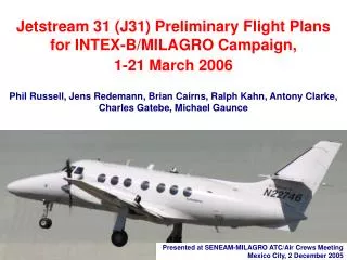
Jetstream 31 (J31) Preliminary Flight Plans for INTEX-B/MILAGRO Campaign, 1-21 March 2006 Phil Russell, Jens Redemann, Brian Cairns, Ralph Kahn, Antony Clarke, Charles Gatebe, Michael Gaunce. Presented at SENEAM-MILAGRO ATC/Air Crews Meeting Mexico City, 2 December 2005.

E N D
Jetstream 31 (J31) Preliminary Flight Plansfor INTEX-B/MILAGRO Campaign, 1-21 March 2006Phil Russell, Jens Redemann, Brian Cairns, Ralph Kahn, Antony Clarke, Charles Gatebe, Michael Gaunce Presented at SENEAM-MILAGRO ATC/Air Crews MeetingMexico City, 2 December 2005
Jetstream-31 in INTEX-B/MILAGRO Specs &Performance
Introduction This is a collection of preliminary flight plans for J31 operations out ofVeracruz and flights over the Gulf of Mexico, land areas downwind of the Mexico City Metropolitan Area (MCMA), and possibly MCMA and the Pacific Ocean, during the March 2006 MILAGRO campaign. As with the preliminary flight plans for the other MILAGRO aircraft, they are based on the following assumptions: • These drafts are intended to initiate negotiations with SENEAM on final flight plans that will accomplish as many of our scientific objectives as possible within the constraints of their air-traffic control system. • These plans may not include all flight scenarios; parts of them may be combined but in general they would be shortened rather than lengthened for actual operations. • Extensive ground-based measurements will be made at two sites to the north of the MCMA, at distances approximately 20 and 40 miles from the center of the MCMA, representing two times, “T1” and “T2”, in the chemical and physical evolution of material transported away from the MCMA, under southerly wind conditions.
The scientific goals of the J31 require flights containing the basic elements or patterns shown below. • Survey Vertical Profile. • (2) Minimum-Altitude Transect. • (3) Parking Garage (Stepped Profile with legs of 3-10 minutes). • (3') Parking Garage with CAR Maneuvers. • (4) Above-Cloud Transect. • (4') Above-Cloud CAR Maneuver. • All J31 scientific instruments measure sunlight, which is strongly influenced by clouds. • Hence, J31 flight patterns are cloud-sensitive: many seek to avoid clouds, while others seek to fly above certain types of clouds. • Because clouds can change quickly and are difficult to predict, J31 flight plans usually require flexibility to change in response to clouds. • One purpose of this package is to find out from SENEAM what areas and conditions are most likely to give us the needed flexibility.
CAR Orbit to measure BRDF Typical flight pattern for CAR BRDF measurements. Flight patterns at several attitudes and Sun angles will be flown during MILAGRO. CAR=Cloud Absorption Radiometer BRDF=Bidirectional Reflectance Distribution Function
J31 Flights—Operational Overview • 10-20 Science Flights from Veracruz (1-21 March 2006) • Typical flight duration: 2-4 hours (45 hours total) • All flights during daylight hours. Nominal takeoff between 8 AM and 4 PM local. Fly seven days/week. • 7 preliminary flight plans to illustrate goals, with flights over Gulf of Mexico, land areas downwind of the Mexico City Metropolitan Area (MCMA), and possibly MCMA and the Pacific Ocean. • Arrive VER from US 28 Feb 2006. Depart VER 22 Mar 2006. • "Parking Garage" pattern is a stepped profile with horizontal legs 3-10 minutes long. • Timing is critical on flights coordinated with satellite overpasses and with other aircraft.
The A-Train is a set of satellites that fly in sequence over a common ground track Many J31 flights will include legs or profiles under the A-Train or other satellites
FLIGHT J31A CALIPSO/A-Train underflight, LaRC KA underflight, CAR maneuvers • 2. 5 minutes straight & level, then spiral descent on CALIPSO/A-Train track. • 2-3. Minimum-altitude leg under A-Train track for gradients of: • AOD (CALIPSO, MODIS-Aqua, OMI-Aura, POLDER), • Water vapor (TES-Aura, AIRS-Aqua, MODIS-Aqua) • Radiation (J31 SSFR) • Spiral up, 5 min straight & level, then parking garage down in MC outflow. CAR orbits at 2,000 ft in parking garage. • 3-4. Climb above aerosols near midpoint of leg. • 4. 10 min straight & level with LaRC King Air, then spiral down in LaRC King Air curtain (see Flight KA1). • CAR maneuvers & AERONET rendezvous at min alt • ■ Matches with plan KA8
FLIGHT J31B Spirals & low leg under LaRC KA, CAR maneuvers (Possible MISR/MODIS Terra underflight, AEGIS* simulation) M.P. = Minimum Permitted altitude • 2. Spiral up under King Air, then 5 min straight & level with KA • 2-3. Minimum-altitude leg under King Air • Spiral ascent under King Air in MC outflow at T2, then 5 min straight & level with KA • Car maneuvers over vegetation • AERONET Cimel rendezvous on landing at airport • ■ Matches with plan KA9 *AEGIS is an aerosol/cloud satellite mission concept being developed by GSFC, GISS, Langley, and JPL.
FLIGHT J31C Spirals with C-130 and/or under King Air, Parking Garage at T1 (Possible MISR/MODIS Terra underflight, AEGIS* simulation) M.P. = Minimum Permitted altitude • 2. Spiral up coordinated with C-130 and/or under King Air, then 5 min straight & level in solar principal plane • Spiral down coordinated with C-130 and/or under King Air in MC outflow at T1 • 3. Parking garage in MC outflow at T1, including CAR orbits at 6,000 ft. • Spiral down coordinated with C-130 and/or under King Air • ■ Matches with plan KA10 *AEGIS is an aerosol/cloud satellite mission concept being developed by GSFC, GISS, Langley, and JPL.
FLIGHT J31D Terra MISR & MODIS underflight, Radiation gradient under MC outflow, Cimel leg • 1-2. Minimum-altitude leg under Terra MISR swath for gradients of: • AOD, Angstrom exponent (MISR, MODIS-Terra), • Water vapor (MODIS-Terra) • Radiation (J31 SSFR) • Spiral ascent in MC outflow including Terra overpass time (1654, 17Mar06), then 5 min straight & level in solar principal plane, then parking garage with CAR BRDF measurement at 2,000 ft. Coordinate spiral w DC-8? • 2-3. Repeat minimum-altitude gradient leg on return • Spiral up, then 5 min straight & level above polarized Cimel at airport. • ■ Matches with plan KA11
FLIGHT J31E CALIPSO/A-Train underflight, NASA King Air & DC-8 coordination in MC outflow, Urban CAR maneuvers 2-3. Minimum-altitude leg under A-Train & King Air for gradients of: - AOD (CALIPSO, MODIS-Aqua, OMI-Aura, POLDER), - Water vapor (TES-Aura, AIRS-Aqua, MODIS-Aqua) - Radiation (J31 SSFR) 3-4-5. Orthogonal low-altitude leg to define gradients below coming spiral. 5 (=3). Spiral up, then 5 min straight & level in solar principal plane, then parking garage in MC outflow including CALIPSO overpass time (1953 UT, 3Mar06). Coordinate spiral w DC-8. 5-6. Climb above aerosols 6. CAR maneuvers at 2,000, 6,000, 8,000 ft.
FLIGHT J31F Pacific CALIPSO/A-Train underflight, CAR BRDF maneuvers over MC AERONET Cimel 2-6. Orthogonal minimum-altitude legs (possibly over stratus) to define gradients below upcoming spiral. 6. Spiral up including CALIPSO overpass time (2003 UT, 17Mar06), then 5 min straight & level in solar principal plane. 7. CAR maneuvers over MC at 2,000, 6,000, 8,000 ft over MC AERONET Cimel.
FLIGHT J31G Yucatan bioburn plume study Note: Plan needs to be shortened and/or broken up to add refueling stops near WP 2 & 4. • 2. Spiral down in bioburn plume • 2-3. Transit under plume at 200 ft. • Spiral up to 23,000 ft, then 5 min straight & level RSP leg in solar principal plane, parking garage down to 200 ft. • 3-4. Transit at 200 ft. or above low cloud deck. • 4. Parking garage up. • 4-5. Transit to Veracruz at altitude.