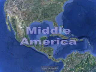
MIDDLE AMERICA
310 likes | 582 Vues
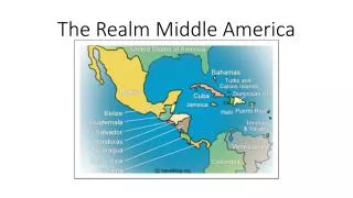
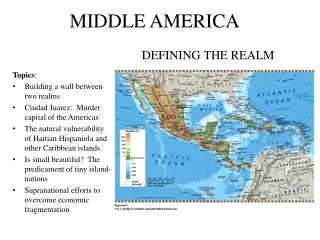
MIDDLE AMERICA. DEFINING THE REALM. Topics : Building a wall between two realms Ciudad Juarez: Murder capital of the Americas The natural vulnerability of Haitian Hispaniola and other Caribbean islands Is small beautiful? The predicament of tiny island-nations

MIDDLE AMERICA
E N D
Presentation Transcript
MIDDLE AMERICA DEFINING THE REALM Topics: • Building a wall between two realms • Ciudad Juarez: Murder capital of the Americas • The natural vulnerability of Haitian Hispaniola and other Caribbean islands • Is small beautiful? The predicament of tiny island-nations • Supranational efforts to overcome economic fragmentation
MIDDLE AMERICAMAJOR GEOGRAPHIC QUALITIES • Small realm—Mainland from Mexico to Panama and islands of Caribbean Basin • Land bridge connecting North and South America • Cultural and political fragmentation • Complex cultural geography—African and European influences in the Caribbean and Spanish and Amerindian influences on the Mainland • The America’s least developed territories • Mexico leads the realm in population, territory, and economic potential • Mexico and Panama connected beyond the realm with the United States
MIDDLE AMERICAGEOGRAPHICAL FEATURES A Troubled Border Zone • Illegal immigrants • About 1 million migrants per year • Smuggling • Drugs, people, etc. • Ciudad Juarez/El Paso The Realm’s Northern Land Boundary • Longest border in the world—3,169 km (1,969 mi) between North and Middle America • NAFTA (North American Free Trade Agreement) • Canada, United States, and Mexico (1994) • Maquiladoras—foreign-owned assembly factories • Assemble imported, duty-free raw materials into finished products • Near U.S.A./Mexico border • 4,000 factories with 1.2 million workers • Mexico provides about 13% of all U.S. imports after Canada (24%)
MIDDLE AMERICAPHYSICAL GEOGRAPHY A Land Bridge • Land bridge—mainland Middle America • Isthmus—narrow strip of land Island Chains • Archipelago—island chain Dangerous Landscapes • Earthquakes • January 12, 2010, Haiti hit by 7.0 earthquake • Hurricanes • Hurricane Alley—along all of the Greater Antilles, southern Florida, Mexico’s Yucatán Peninsula and the Gulf of Mexico The Regions • Mexico • Central America • Greater Antilles • Lesser Antilles
MIDDLE AMERICAPHYSICAL GEOGRAPHY Altitudinal zones—distinct local climates, soils, vegetation, crops, domestic animals and modes of life. • Tierra caliente—sea level to 750 m (2,500 ft) • “Hot land” • Coastal plains and low-lying basins • Tropical agriculture • Tierra templada—up to about 1,800 m (6,000 ft) • Temperate land—cooler • Commercial crops—coffee, corn, wheat • Tierra fría—1,800 to 3,600 m (6,000 to 12,000 ft) • Cold country of Andes • Potatoes and barley • Tierra helada—3,600 to 4,500 m (12,000 to 15,000 ft) • Above tree line • Cold and barren • Sheep grazing and hardy livestock • Tierra nevada—highest zone • Permanent snow and ice
MIDDLE AMERICAPHYSICAL GEOGRAPHY Tropical Deforestation • Only 10% of tropical rainforest remains • Leading causes • Clearing rural lands for cattle pasture • Rapid logging of tropical woodlands • Population explosion • Peasants must extract subsistence from inferior lands • Cutting trees for firewood and crop-raising space • Major effects • Erosion of top soil • Loss of ecological resources • Increased mining/extraction • Biodiversity threatened • Coral reefs and fish • Tropical rainforest mammals • Foods, Medicines, Tools
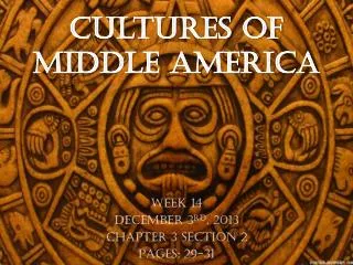
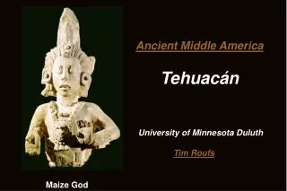
MIDDLE AMERICACULTURAL GEOGRAPHY Mesoamerican Legacy Culture hearth • Source area from which new ideas radiated and whose population could expand and make significant material and intellectual progress. • Agricultural specialization, urbanization, transportation networks, writing, science, art. Mesoamerica—southeast of Mexico City to central Nicaragua • Low-lying tropical plains of northern Guatemala, Belize, and Yucatán Peninsula • Guatemala highlands • Plateau of central Mexico
MIDDLE AMERICACULTURAL GEOGRAPHY The Highland Aztecs • Intermontane highland zone of Mexico • Teotihuacan • North of Mexico City • First true urban center in the Western Hemisphere • Valley of Mexico • Tenochtitlan • Functioning city and ceremonial center • Developed irrigation systems • Constructed walls to terrace slopes • Domesticated corn (maize), sweet potato, cacao bean, tobacco Mesoamerican Legacy The Lowland Maya • Only major culture hearth that arose in the lowland tropics • Great cities with stone pyramids and massive temples • Zenith from 3rd to 10th centuries AD • Powerful religious hierarchy • *Population = 200 million people • Mexico is largest in size and population (114 million).
MIDDLE AMERICACULTURAL GEOGRAPHY Spanish Conquest Introduced • Cattle and sheep • Wheat • Spanish town • Plaza or market square • Gridiron street pattern Collision of Cultures • Amerindian • Spanish • Other European • British, Dutch, French • African • United States—later
MIDDLE AMERICAPOLITICAL AND ECONOMIC FRAGMENTATION Independence • Mexico—1821 • Central America republics—end of 1820s • Spanish-American War—1898 • Cuba—independent • Puerto Rico—under U.S. flag • Trinidad and Tobago—1962 • Jamaica—1962 Rimland • Caribbean coast of mainland • Islands • European-African • Sugar and banana plantations • Imported Labor Mainland • Euro-Amerindian—Mestizo • Mexico to Panama • Haciendas
MIDDLE AMERICAPOLITICAL AND ECONOMIC FRAGMENTATION Connectivity: direct links between locations. • Connections and correlation to economic development. • Higher GDP • Mexico’s connection with the United States. • Panama’s connection to world economy. • Economies best with countries bordering Middle America. The Push for Regional Integration • Economic Benefits • CAFTA—Central American Free Trade Agreement (2005) with USA. • CARICOM—Caribbean Community (1989) • 15 members, common passport (2009).
MIDDLE AMERICAPOLITICAL AND ECONOMIC FRAGMENTATION Small-island developing economies: • Limited natural resources and heavy reliance on imports. • Cost of government is relatively high on per capita basis. • Specialized services brought in from elsewhere. • Local production cannot really benefit from economies of scale • Local producers cannot compete with cheaper imports • Unemployment, poverty • Caribbean tourism • Money-maker for islands. • Rising local resentment. • Debases local culture. • Can remove opportunities from local entrepreneurs in favor of large operators and major resorts. *Solutions: Fair-trade prices, environmental preservation/ecological restoration, cultural heritage education, and local ecotourism.
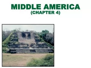
MIDDLE AMERICA REGIONS OF THE REALM Topics: • Mexico’s drug wars • Indigenous peoples demand recognition and rights • Panama Canal expansion fuels boom in Panama City • Aftermath of Haiti’s 2010 killer earthquake • The debate over Puerto Rico’s status
MIDDLE AMERICAMexico Physiography • Peninsula of Baja • Yucatán Peninsula • Isthmus of Tehuantepec • Sierra Madre Occidental • Sierra Madre Oriental • Plateau of Mexico • Valley of Mexico Regional Diversity • Core Area—Mexico City to Guadalajara • Hispanic-mestizo north • Amerindian south • Gulf Coast—Mexico’s petroleum center • NAFTA-driven north • Economic development
Mexico Population Patterns • Growth slowing, drop in fertility • Distribution • Concentrated in core area • Veracruz State to Jalisco State • Federal District of Mexico City • Least-populated in North • High rate of urbanization • 77% live in towns and cities • Low rate of urbanization • Amerindian highlands Mexico City • Almost 30 million • 26% of national population • Largest urban concentration on Earth
Mexico Mix of cultures Fusion of heritages • Acculturation—one-way incorporation of European culture. • Transculturation—two-way exchange of cultural traits. • Strong Amerindian influence • Linguistic • Dress, foods, artistic, and architectural styles and folkways Agriculture: Fragmented Modernization • Ejidos—government-held farmlands parceled to village communities and individuals (1917) • Amerindian legacy • Half of lands “social landholdings” • Reforms did not increase production • Low yields and rural poverty • Northern agriculture • Major irrigation projects, mechanized cotton production
Mexico Shifting Economic Geographies Maquiladoras—foreign-owned assembly factories that export products back to USA. • One-fifth of Mexico’s industrial jobs • Long hours, low wages, few benefits • No job security • Great Recession in the U.S. • Plants relocated to Southeast • Political consequences • Guerrilla war in Chiapas—Zapatista National Liberation Army (ZNLA). • 2006 presidential campaign—conservative versus populist. Regional Disparities • North vs. South • North: higher income, lower rural poverty. • South: less economic growth and infrastructure investment.
Mexico The Drug Wars • Colombian drug cartels established new bases in northern Mexico • Cartel competition • Territorial control over entry points, processing, and transport routes • Failed state—loss of government control over parts of its own territory. Mexico’s Future • Government Challenges • End violence, regional inequalities, wage gap. • Increase NAFTA southward (infrastructure/education/antipoverty). • Possibility of a dry canal across the Isthmus of Tehuantepec to compete with the Panama Canal
MIDDLE AMERICAThe Central American Republics A Land Bridge • Between Mexico and South America • Seven countries • Highland belt flanked by coastal lowlandson both the Caribbean and Pacific sides • Biodiversity hot spot • Contains 7% of all the world’s natural species. • Costa Rica and Panama • Ecology threatened by humans. • Tierra templada—cooler uplands • Tierra caliente—tropical coastal lowlands
Belize Guatemala • British Honduras—Dependency of the United Kingdom until 1981 • Similar to Caribbean islands • Population of African descent • Becoming increasingly Hispanicized • Economic sphere • Sugar, bananas, seafood-processing, clothing industries, tourism. • Offshore banking—financial haven for foreign companies. • Heart of Maya Empire • Mestizo—59% • Amerindian—41% • Ladinos—better-off mestizos • Mineral wealth • Nickel and oil • Agriculture • Coffee
Honduras • Still recovering from Hurricane Mitch in 1998 (Cat-5). • Third poorest economy in the realm. • Potential for ecotourism. • Hindered by poor infrastructure and lack of funds. • Economic sphere • Agriculture • Bananas and coffee • Livestock • Forestry • Limited mining • Apparel • Smallest country territorially • Most densely populated • Most homogeneous population—85% mestizo • Coffee republic • 1980-1992 Civil War • Arms supplied by outside states (US and Nicaragua) • Remittances sent by affluent émigrés—largest single source of foreign revenues. El Salvador
Costa Rica Nicaragua • Political stability • Democratic tradition—no standing army since 1949 • Remote from regional strife • Concentrated on economic development • Region’s highest standard of living, literacy rate, and life expectancy. • Triangle of land • Pacific side—country’s core • Caribbean side—Amerindian peoples (Miskito) • Agriculture dominates economy. • Reliance on remittances from Nicaraguans who have emigrated and foreign aid. • Tierra templada—the Valle Central (Central Valley) • Main coffee-growing area • Leading population cluster—San José • Agriculture • Bananas, coffee, tropical fruits, and seafood • Tourism - excellent.
Panama • 70% Mestizo • Spanish—official language • Cólon (Cólon Free Zone)—entrepôt (designed to transfer and distribute goods bound for South America). • Manzanillo International Terminal—ultramodern port facility • Panama City—financial center for canal revenues and drug industry. • The Panama Canal (1914) • 1977-1999—staged withdrawal of the United States from the Canal Zone • Expansion of Panama Canal • boost interoceanic traffic and increase business opportunities Which countries benefit most from Panama canal?
MIDDLE AMERICATHE CARIBBEAN BASIN Fragmentation and Insularity • Island arc in Atlantic Ocean from Cuba to Trinidad. • Greater Antilles • Four larger islands in the west (Cuba, Hispaniola, Jamaica, Puerto Rico) • Lesser Antilles • Eastern segment of smaller islands reaching to the South American coast Ethnicity and Class • Social stratification • Closely linked with ethnicity, as result of colonial times. • Rankings • Europeans • Hispanics • Mixed European-African (mulatto) • Afro-Caribbean • Minorities hold power and exert influence (historic advantage). • South and East Asian presence • After end of slavery, groups arrived as indentured laborers.
CUBA • Largest island-state—territorially and in population. • Independence in 1898—Spanish-American War. • 1959-overthrew American-backed dictator. • Fidel Castro—communist dictatorship • 2006—Turned over to Raúl Castro • Economic opportunities • Raw materials—nickel and timber • Agriculture—sugar, tobacco, rice, tropical fruits • Venezuelan oil • Former British dependency • Member of British Commonwealth • English - official language • Entirely Afro-Caribbean population • Raw materials--Bauxite • Agricultural—Sugar, bananas, tobacco • Must import all of its oil and much of its food • Tourism—largest source of income JAMAICA
HAITI • Poorest state in the Western Hemisphere. • Environmental disasters • Center of “Hurricane Alley” • 2008—four tropical cyclones in one season • Atop dangerous fault zone • 2010—killer earthquake • Few natural resources, major deforestation. • History of political instability, repression, and deprivation. • Heavy reliance on aid and remittances. DOMINICAN REPUBLIC • Wider range of natural environments. • Stronger resource base—nickel, gold, silver. • Agriculture—sugar, tobacco, coffee, cocoa. • Tourism
PUERTO RICO • 1898 Spanish-American War • U.S. Commonwealth • 1948 permitted to elect governor. • Puerto Ricans are U.S. citizens. • Receives annual subsidies from the USA. • Long dependent on single-crop economy (sugar). • Massive emigration. • Trinidad & Tobago (Port of Spain) – exports shipped to wealthy nations. • Ex. Natural Gas, Ammonia, Methanol
THE LESSER ANTILLES • The Bahamas—former British colony. • Trinidad and Tobago • Oil/Natural gas producer. • Influx of energy, chemical, and steel companies. • Largest supplier of liquefied natural gas for United States. • Small-island developing economies • Some islands chose to maintain a political relationship with former colonial ruler. • Curaçao, Aruba and St. Maarten • “Countries” within the Kingdom of the Netherlands • Leeward Islands and Windward Islands • Environmental risks • Earthquakes, volcanoes, and hurricanes. • Socioeconomic problems • Limited resources, overpopulation, difficult agricultural industry, and market limitations.
Homework Read Textbook Chapter 4a/b Homework: Choose one “@from the Field Notes” subsection topic in Ch.4 textbook; research and summarize (1 page). OR Choose a realm/region within or adjacent to Middle America to review in detail (1 page). Use Chapter 4b for ideas and information, research and summarize.