The Impact of Geography on Ancient Egypt's Economy and Culture
This overview explores how the geography of Western Egypt, particularly the Nile River, shaped the ancient economy and culture. The Nile, flowing north to the Mediterranean Sea, provided water, fertile soil, and transportation routes, crucial for trade. Its annual floods created rich farmland, enabling the growth of staple crops like wheat and grains. The development of irrigational techniques such as the shaduf and the use of the nilometer were pivotal in optimizing agricultural output. Overall, the Nile fostered a thriving economy that greatly influenced the way of life in ancient Egypt.

The Impact of Geography on Ancient Egypt's Economy and Culture
E N D
Presentation Transcript
Egyptian Geography Ms. Orville
Geographical • Terrain Different maps
N DO: How did the geography of W Egypt impact the economy?
The Nile flows North up to the Mediterranean Sea • The world’s longest river: 4,000 miles • Floods annually • Plant, grow, and harvest • Inundation- flood • The year is divided into 3 seasons based on the flooding of the Nile • At the northern part of the river, it splits into many streams and forms an area called a delta • The water deposited silt, a rich soil making the land fertile Geography of the Nile
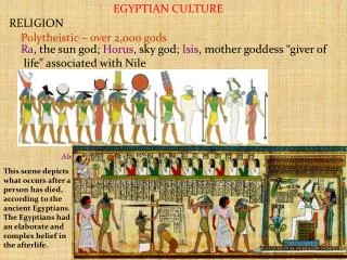
The Nile provided the ancient Egyptian and Nubian peoples with water, food, fertile soil, transportation for trade, and protection from invaders • The Nile River and its valleys were central trade routes for the ancient Egyptians and Nubians • Reed called papyrus grew along the banks of the Nile • Used to make the world’s first paper • Made Egypt wealthy • Farming was the basis for the economy of ancient Egypt • Economy of a country is its use of workers and resources to produce goods • Ancient Egypt’s economy: crops of wheat and other grains • Irrigation- the watering of dry land by means of streams, canals, or pipes • Helps farmers grow more crops • Shaduf- a machine (lever) that helped move water to irrigate fields • Nilometer- measuring device to help predict the height of coming flood waters- could better prepare fro planting season