Download
1 / 24
240 likes | 402 Vues
High Resolution Assimilation of Radar Data for Thunderstorm Forecasting on OSCER . Keith A. Brewster, Kevin W. Thomas, Jerry Brotzge, Yunheng Wang, Dan Weber and Ming Xue CAPS and School of Meteorology University of Oklahoma 2007 OSCER Supercomputing Symposium Norman, Oklahoma, October, 2007.

E N D
High Resolution Assimilation of Radar Data for Thunderstorm Forecasting on OSCER Keith A. Brewster, Kevin W. Thomas, Jerry Brotzge, Yunheng Wang, Dan Weber and Ming Xue CAPS and School of MeteorologyUniversity of Oklahoma 2007 OSCER Supercomputing Symposium Norman, Oklahoma, October, 2007
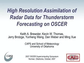
CASA & NEXRAD Radars • CASA NetRadNSF ERC: Collaborative Adaptive Sensing of Atmosphere • X-Band Dual-Polarization Radars • 30 km nominal range • Dual-Pol attenuation correction • Clutter filter • Collaborative, Adaptive Scanning • Fill-in below coverage of NEXRAD • Toward phased-array panels – low-cost! • NEXRAD • S-Band Radars • Current Weather Service Operational Radars • 14 covering domain • Data used out to 230 km
CASA NetRad IP1 Southwest Oklahoma
Near Real-Time NWP Runs • Four Runs in Near Real-time • 9 Weeks in Spring 2007 • 6-hour 1-km resolution forecasts • Use Reflectivity • ARPS Model • ADAS Analysis with cloud analysis and latent heat adjustment • Run on Parallel Linux Boxes OU OSCER (150 proc/2 runs at a time) • Hourly output graphics posted to web: http://www.caps.ou.edu/wx/casa
Forecast Domain Dx = 1 km nx=603 ny=543 nz=53
Assimilation Strategy 40-min Assimilation 5.5-hour Forecast IAU IAU IAU IAU 2150 2200 2210 2220 2230 00 01 02 03 04 Forecast Model started manually when storms enter the network or with initial development within the network
Computing - Networking CASA SOCC CASA Radars NFS IDD (Internet) CAPS Ingest Cluster OSCERTop DawgHPC IDD (Internet) NexRad Radars Other WeatherObservations Internet CAPS Webserver DataFile Archive Other NumericalWeather Model Data
Computing – Number Crunching TopDawgTotal 1024 processorsPentium4 Xeon EM64T 3.2 GHzGigE Network (976 Mbps, latency 9 ms) ARPS Analysis/Forecast150 processors per job (75 nodes)4 forecasts, 2 jobs run at a timeHorizontal Domain Decomposition, MPICH2 15x10 processors6 - 6.5 h wall for each forecast1 - 1.5 h wall for data processing and analysis~50 GB of data each day created for archive
Summary of 2007 Cases • 21 Sets of Runs for 20 Cases • Weather Summary: • With Funnels and/or Tornadoes (2) • Squall Lines (8) • Clusters of Cells or Individual Cells (6) • Broken Lines and/or Cells on Boundaries (5) • Precip Area with Synoptic Scale Low (1) • Some developing, some intensifying, decaying • Wide Range of Time-of-Day
Sample Impact of CASA NetRad Data ADAS Analysis of Hydrometeors Converted to Reflect Hgt=~250 m AGL NEXRAD Only NetRad & NEXRAD
Cross-Section NEXRAD & NetRad NEXRAD Only NetRad Low-Level Info
40 min - End of Assimilation Period ReflectivityAll Radars Refl + VrAll Radars KTLX (Verif)
40 min - End of Assimilation Period ReflectivityAll Radars Refl + VrAll Radars KTLX (Verif) Stronger Vort Improved Refl
2-hour Forecast KTLX (Verif) Refl + VrAll Radars ReflectivityAll Radars
2-hour Forecast KTLX (Verif) Refl + VrAll Radars ReflectivityAll Radars Stronger, Closer
2-3 hr Vorticity Forecasts Triangles: ObservedCirculations No Radar Data
2-3 hr Vorticity Forecasts Solid Green: NetRad Only Orange: NexRad Only Red: Reflectivity Both
2-3 hr Vorticity Forecasts Radial Velocity Data Used fromAll Radars Four Circulations Tracked in this run
Accomplishments • Completed MPI of ADAS with cloud analysis • Able to process CASA radar • Automated Data Selection • Data I/O and Quality Control (ref & vel) • Remapping and hydrometeor assignment • Reflectivities are well-handled in model • Baseline Runs Complete
Ongoing/Future Work • Complete MPI of Vr analysis and run simulations with Vr • Detailed verification of model forecasts • Comparison of QPF to NSSL 1-km Q2 • Comparison of location and strength of forecast circulation centers vs. radar-observed circulation centers (April 10, May 8/9) • Prepare for 2008 Experiment • Complete MPI of 3DVAR and comparison of results • Integrate NWP in end-user training • Design near real-time evaluation for integration in NWC Hazardous WeatherTestbed