Download

1 / 32
320 likes | 511 Vues
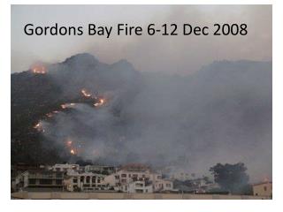
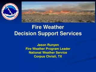
Laureles Fire Feb. 6-7, 2008. Fire Weather Decision Support Services Jason Runyen Fire Weather Program Leader National Weather Service Corpus Christi, TX. NWS Forecast Office Areas. NWS Fire Weather Products. Fire Weather Planning Forecasts Fire Weather Watches Red Flag Warnings

E N D
Laureles Fire Feb. 6-7, 2008 Fire Weather Decision Support Services Jason Runyen Fire Weather Program Leader National Weather Service Corpus Christi, TX
NWS Fire Weather Products • Fire Weather Planning Forecasts • Fire Weather Watches • Red Flag Warnings • Fire Danger Statements • Fire Warnings • Hourly Forecasts & Graphical Products on the Web
Fire Weather Planning Forecast • Used by land management personnel for input in decision-making related to pre-suppression and other planning • These decisions can impact firefighter safety, protection of the public and property and resource allocation • Issued daily by NWS Corpus Christi by 6:30 AM & 4 PM. • (updated as needed))
NWS Products and Services Fire Weather Planning Forecast
Red Flag Event Products • Fire Weather Watch • Generally 12-96 hours in advance of event • Reasonably Confidence • Can be issued first 12 hours for dry lightning events • WWUS84 KCRP (SATRFWCRP) • Red Flag Warning • Within 24 hours in advance of event • High degree of confidence • WWUS84 KCRP (SATRFWCRP)
When Fuels are Cured Red Flag Criteria Coastal Counties RH at or below 40% And 20-Foot winds sustained or frequently gusting at or above 25 mph Inland Counties RH at or below 30% And 20-Foot winds sustained or frequently gusting at or above 25 mph These conditions have been determined to be critical to wildfire potential and growth across South Texas
Red Flag Criteria When Fuels are not Cured • Red Flag Weather Criteria • AND • 2) Dry to Extremely Dry Fuel Moisture
Fire Danger Statements • Issued for Sub-Red Flag Warning Events (elevated but not critical) • Conditions can still have significant impact to land management agencies • Similar to an Advisory • FNUS64 KCRP (SATRFDCRP)
Fire Warnings • A warning of a spreading wildfire or structural fire that threatens a populated area • Evacuation of areas in the fire’s path may be recommended • Issued by request of authorized Emergency Manager • Can trigger EAS • SATFRWCRP
iNWS Text/Email Messaging Notification • Ability to receive text messages and email alerts for NWS Watches, Warnings & Advisories • Customizable • Products you want • County, Zip Code or user defined geo-targeted areas
iNWS Text/Email Messaging Notification http://inws.wrh.noaa.gov
iNWS Text/Email Messaging Notification Example Red Flag Warning Fire Danger Statement
iNWS Text/Email Messaging Notification Example
Fire Weather Products on our Website www.weather.gov/corpuschristi
South Texas Fire Weather Digital Services on the internet
South Texas Fire Weather Digital Services on the internet
South Texas Fire Weather Digital Services on the internet
Fire Weather Point Forecasts www.weather.gov/fire
Fire Weather Point Forecasts www.weather.gov/fire
Email Briefings • High Impact Events • Weekly Briefings during Peak of Fire Season • Fire Partners make sure we have your email address
Laureles Fire Feb. 6-7, 2008 Thank You! Jason Runyen Fire Weather Program Leader NWS Corpus Christi, TX 361-289-0959 Jason.Runyen@noaa.gov