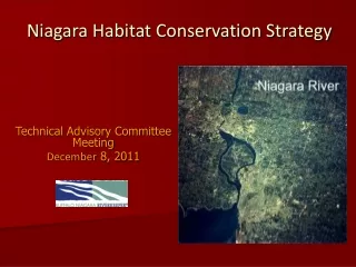
Niagara Habitat Conservation Strategy
320 likes | 425 Vues
Niagara Habitat Conservation Strategy. Technical Advisory Committee Meeting December 8, 2011. Project Purpose and Goals. Purpose

Niagara Habitat Conservation Strategy
E N D
Presentation Transcript
Niagara Habitat Conservation Strategy Technical Advisory Committee Meeting December 8, 2011
Project Purpose and Goals Purpose Provide a scientifically driven, stakeholder influenced blueprint for ecosystem-based planning and habitat conservation in the Niagara River Watershed and Niagara River Greenway. Funding • EPA GLRI Grant (2 years) • GESC Grant (Phase I-9 months)
Goals • Identify key species, natural communities, ecological systems, and biotic processes in greatest need of conservation • Identify ecological and landscape connections • Identify opportunities to abate critical threats and restore degraded biodiversity features • Focus actions where most likely to have the most impact • Contribute to delisting the Niagara River as an AOC • Foster regional stakeholder support for goals and actions.
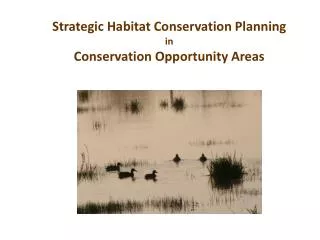
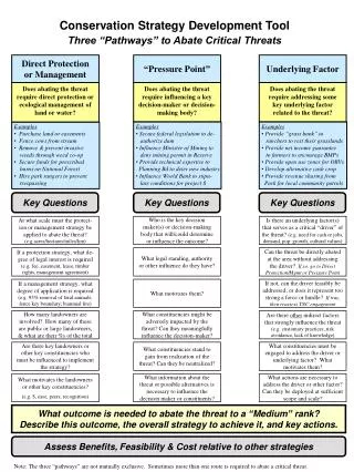
ConservationAction Planning Model (TNC) A step-wise framework intended to guide practitioners: • Develop and focus conservation actions on clearly defined biodiversity features/targets • Fully articulate threats to specific features • Identify actions to abate critical threats and restore degraded features
Why the CAP Model? • Scientifically driven • Clearly defined, logical, organized • Applicable and useful at all scales • Adaptive and flexible • Stakeholder influenced • Focuses actions where they are likely to have the most impact • Regionally relevant
Niagara Habitat Conservation Strategy Timeline July through October 2011 • Kick-off TAC meeting • Draft and finalize project scope and mission • Develop draft biodiversity features and goals • Stakeholder meeting in September • TAC meeting end of September • Finalize biodiversity features and goals October through June 2012 • Assess viability of biodiversity features • Draft attributes and indicators • Identify threats and critical threats • Conduct intensive GIS analysis to identify linkages and opportunities • Meet or conference with TAC at least 4 times formally • Hold several formal stakeholder meetings • Develop conservation actions
Timeline Cont’d July through December 2012 • Develop conservation actions • Field Assessments/Groundtruthing • Meet formally with TAC 3 times • Hold several stakeholder/public meetings • Identify indicators and methods to measure effectiveness of actions • Organize information into strategy document • Seek review and comment on strategy document • Finalize strategy document
Project Milestones to Date • Quality Assurance Project Plan (QAPP) approval obtained on October 22, 2011 from USEPA • Vision Statement developed and finalized • Aquatic project scope • Ongoing public and stakeholder outreach • Active River Area map drafted depicting project planning area
Vision Statement Building upon completed and ongoing regional habitat conservation work, restore and conserve native ecological communities and biological integrity by promoting healthy, self-sustaining aquatic ecosystem functions within the Niagara River watershed.
Active River Area What is it? A visual and spatial representation of rivers that includes the channels and riparian lands necessary to accommodate the physical and ecological processes associated with river systems. • “Active”-Dynamic physical processes form, disturb and maintain different aquatic and riparian habitat components over space and time • “River Area”- Lands that contain both aquatic and riparian habitats as well as those that contain processes that interact with a river or channel. • Physical processes include system-wide hydrologic connectivity, floodplain hydrology, and sediment movement along a river corridor • Considers physical processes and habitats in relation to three watershed positions; upper, mid, and lower
Why Useful? Vision Statement Building upon completed and ongoing regional habitat conservation work, restore and conserve native ecological communities and biological integrity by promoting healthy, self-sustaining aquatic ecosystem functions within the Niagara River watershed. The Active River Area (ARA) visually identifies the physical space within which to focus conservation efforts to achieve our project’s vision in the Niagara River watershed.
Methodology of the ARA Uses Geographic Information System (GIS) modeling paired with scientific framework Delineates: Five Components • Material Contribution Area • Meander Belt • Floodplains • Terraces • Riparian Wetlands Uses (2) major GIS datasets as inputs: • USGS/USEPA National Stream Hydrography Dataset (1:100,000 scale) for stream lines and orders • 30m Digital Elevation Model (DEM) for elevation and slope
Material Contribution Areas: Headwater areas and certain upland areas directly adjacent to stream channels; key building blocks of downstream hydrology, channel structure and habitat conditions. Upper Watershed • Uplands where intermittent streams form and come together to create the first and second order perennial streams • Significant areas that contribute inorganic and organic materials to river system downstream and form the basis of the food web Mid Watershed • Uplands and steep slopes along small tributary streams emerging from confined valleys and along steep valley walls where no floodplains, terraces, or wetlands exist Lower Watershed • Most materials coming from upstream sources and from areas within other ARA components • Areas along bluffs or steep banks along small tributaries may be locally important
Meander Belt:Area within which the channel will migrate over time; most “active” part of the ARA Upper Watershed • Can be narrow in small, straight and steep headwater channels or slightly wider in headwater wetland dominated systems • Step-pool channels common; confined valleys and coarse bed particles limit lateral movement of meander belt Mid-Watershed • Wider and more dynamic than upper watershed; degree of valley confinement determines width in part • Dominant processes are downstream transfer of water, sediment, and energy Lower Watershed • Often wide and sinuous; fine sediment • Dominant processes are sediment and flood storage
Floodplains:Expansive and low sloped areas, often with multiple channels and deep deposits of sediment and other materialsTerraces:Former floodplains when river was flowing at higher levels Upper Watershed • High floodplains and terraces minimal; small expanse of floodplain critical to maintain downstream channel and habitat stability Mid-Watershed • Presence is a function of valley confinement • Critical habitats for aquatic, floodplain, and terrestrial species/communities; inundation determines flood water, sediment, and organic material storage regimes, as well as uptake Lower Watershed • Broad and flat with low to medium energy • Floodplain inundation and storage of fine sediments transported from upstream are key processes
Riparian WetlandsLow gradient areas with inundated or hydric soils that support wetland plant species Upper Watershed • Important role in direct and indirect retention and downstream delivery of organics and nutrients • Extent of wetlands defined by valley confinement versus broad, flat headwater areas Mid-Watershed • Direct link between channel and floodplain, stabilizing banks and providing large woody debris and coarse particulate organic matter • Important water storage areas; help to reduce stream power downstream Lower Watershed • Wide, often extending across valley floor and within floodplain • Integrally linked to river hydrology by ground and surface water, having a strong influence on disturbance regime of channel and floodplain
Active River Area GIS Toolkit Created by The Nature Conservancy, June 2010 • Active River Area (ARA) Three-Stream Class Toolbox • Scale: 1:100000 (vector) and 30 meter (raster) • Software: ArcGIS 9.3 with Spatial Analyst extension • Digital Elevation Model • Source: USGS • Scale: 30m • Each cell (pixel) contains an elevation value • Hydrography • Source: USGS National Hydrography Dataset lines and polygons • Scale: 1:100000 • Stream Order: • Headwaters : 1st and 2nd Orders • Medium: 3rd and 4th Orders • Rivers: 5th Order • Converted from vector to raster for use in ARA model
GIS Data Input Digital Elevation ModelNiagara River Watershed
Hydrographyby stream orderNiagara River Watershed GIS Data Input
Model Results - Active River Area • Blue areas represent: • Meander Belts • Riparian Wetlands • Floodplains • Terraces • Material Contribution Areas
Niagara River Watershed Dark blue represents ‘Medium Streams’ Light blue represents ‘Headwaters’ Hydrography by Stream Order Newstead and Corfu, NY
Darker shading represents lower elevations Elevation Model Newstead and Corfu, NY
Active River Area Model Results are in green Active River Area Newstead and Corfu, NY
Active River Area Model Results compared to 100-Year Floodplains Active River Area with 100-Year Floodplains Newstead and Corfu, NY
Forested Land Cover based on NOAA LULC, 2005: Deciduous Forest Mixed Forest Evergreen Forest Forested Areas within the Active River Area Newstead and Corfu, NY
Light Blue represents 100-Year FEMA Floodplains Dark Blue represents NWI wetlands. Wetlands and Floodplains within the Active River Area Newstead and Corfu, NY
ConservationAction Planning Model (TNC) A step-wise framework intended to guide practitioners: • Develop and focus conservation actions on clearly defined biodiversity features/targets • Fully articulate threats to specific features • Identify actions to abate critical threats and restore degraded features
Biodiversity Features (conservation targets) Definition: Limited suite of species, ecological communities, and ecological systems that are chosen to represent and encompass the biodiversity found in the project area. Nested Features Definition: Species, ecological communities, or ecological systems whose conservation needs are subsumed in one or more biodiversity feature. Example: Biodiversity Feature: Native Migratory Fish Nested Features: Lake Sturgeon, Walleye, Lake Trout
NIAGARA WATERSHED Biodiversity Features – Draft 12/8/2011 1. Upper and Middle Tributary Open Water Aquatic Habitat Open water habitat in mid and upper tribs including 1st order streams (& ag ditches and drains) in ARA 2. Riparian/Coastal Zone Active floodplain, emergent & woody wetlands in ARA, including springs, seeps and headwater wetland areas 3. Riparian/Coastal Woodlands Deciduous, evergreen and mixed forest within or continuous w/ ARA 4. Riparian/Coastal Grasslands/Shrublands Meadows, early successional farmlands, capped landfills (?) within or continuous with the ARA Additional NIAGARA GREENWAY/AOC* Biodiversity Features 5. Riverine Open Water Aquatic Habitat: Nearshore and Benthic Niagara River and lower tribs including Nearshore: 6-foot depth to mean high water; and Benthic: >6 feet deep. 6. Natural Beaches and Islands Sand or gravel beaches; islands and breakwalls 7. Unique Area: Niagara Gorge Including six miles of cliffs, talus slope, bedrock shoreline and vegetated rim between falls and n. edge of escarpment 8. Native Migratory Fish Self-sustaining, native fish communities: e.g. objectives of the Great Lakes Fishery Commission 9. IBA targeted bird species not otherwise captured Including wintering and migratory waterbirds
Contact Information Kerrie Gallo, Project Director 716.852.7483 x 30 kgallo@bnriverkeeper.org Margaret Wooster, Co-Director 716.852.7483 x15 mwooster@bnriverkeeper.org