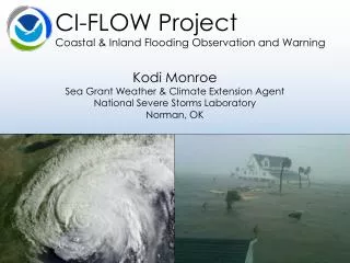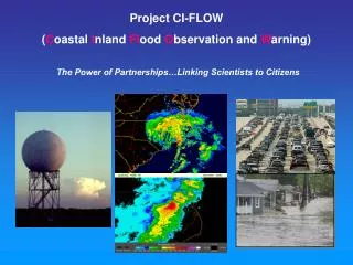
The CI-FLOW Project
150 likes | 175 Vues
CI-FLOW project aims to improve flood warning by tracking raindrops from sky to sea and enhancing NOAA's water quantity and quality info for coastal residents. It addresses the increasing need for hydrologic information as coastal populations grow and evacuations for storms become critical, with a focus on capturing antecedent storm conditions and storm surge simulations. The project integrates inland river and coastal ocean models to predict water quantity and storm surge dynamics efficiently.

The CI-FLOW Project
E N D
Presentation Transcript
The CI-FLOW Project Suzanne Van Cooten Hydrometeorology
CI-FLOW Outline (Coastaland Inland FLood Observation Warning) Relevance • Floods are responsible for the highest number of storm related fatalities • Hydrologic extremes (drought and flood) are responsible for billions of dollars of economic loss annually • - Over half of the nation’s population lives in coastal areas of the United States • - CI-FLOW will demonstrate the capacity to track a raindrop from the sky-to the summit-to the sea to increase NOAA’s capabilities in providing water quality and quantity information to residents of coastal watersheds NSSL Laboratory Review February 17-19, 2009
Existing NOAA Hydrologic Information Service Gap- A Need for Coastal Watersheds And Their Tidal Plains Enfield is the only forecast point in the entire basin which the SERFC produces a 5 day forecast for river stage In non-flood situations, the only river information for yellow triangle locations from the NOAA NWS SERFC or NWS forecast office in Raleigh or Morehead City is a stage reading taken at 8AM and a 24 hour change Downstream of Greenville, the NWS does not produce any river forecasts and does not disseminate river stages or forecasts NSSL Laboratory Review February 17-19, 2009
Increasing Need For Hydrologic Information As Coastal and Migratory Populations Increase Dare County population has increased almost 5 times since 1970 Brunswick County (Wilmington, NC Area) accounts for the largest number ofseasonal housing(16,376) followed by Carteret and Dare Counties Over half of the housing units in Dare County are seasonal Inland counties of the Tar River Basin have some of the largest population densities in the region Pitt County has nearly doubled its population and has the highest population density NSSL Laboratory Review February 17-19, 2009
Future Evacuations For Coastal Storms Moves Increasing Numbers of Citizens Inland To Growing Centers Of Population By 2030, at the height of the tourist season, it would take 46 hours to clear U.S. 158 and 31 hours to clear U.S. 64 through Columbia. Number of evacuating vehicles for a Cat. 3 hurricane during high (95%) occupancy NSSL Laboratory Review February 17-19, 2009
Capturing the Antecedent and Early Storm Conditions • CI-FLOW River Model Suite Provides Streamflow Simulations for Streams and Mainstem Rivers- • NWS Hydrology Lab Research Distributed Model (HL-RDHM) and • 2) Academic Research Models CI-FLOW State of the Science QPE- NSSL, OHD, NESDIS, and RFC Stage 4 Precipitation Estimates Using Radar, Satellite, Lightning, Gauge, and Atmospheric Sounding Data Fields NSSL Laboratory Review February 17-19, 2009
Capturing the Storm Surge L L L Storm Surge • CI-FLOW Ocean Model Suite Provides Storm Surge Simulations (Water Levels) for coastline and for coastal streams, tidal creeks, and bays- • University of North Carolina- Chapel Hill and University of Oklahoma ADCIRC (IOOS Funding) • 2) North Carolina State University EstuaryLower River FloodModeling System NSSL Laboratory Review February 17-19, 2009
8 6 4 2 0 1 2 3 4 5 6 12 10 8 8 6 6 4 4 2 2 0 1 2 3 4 5 6 0 1 2 3 4 5 6 CI-FLOW Will Demonstrate the Capability For A Coupled System Joining The Inland River Model Ensemble and Coastal Ocean Model Ensemble To Provide Simulations of Water Quantity Storm Surge Predicted By Ocean Models Pushes Salt Water Plume Upstream Secondary Fresh Water Storm Crest Predicted By Inland River Models as Upland Tributaries Drain and Ocean Models Track Receding Storm Surge Fresh Water Storm Crest Predicted By Inland River Models Secondary Fresh Water Storm Crest Predicted By Inland River Models as Upland Tributaries Drain and Ocean Models Track Receding Storm Surge Storm Surge Predicted By Ocean Models Pushes Salt Water Plume Upstream Fresh Water Storm Crest Predicted By Inland River Models Water Level Primarily Due to Fresh Water Storm Crest Water Level Primarily Due to Storm Surge Water Level Primarily Due to Fresh Water Storm Crest L L L L L Storm Surge NSSL Laboratory Review February 17-19, 2009
Bringing CI-FLOW into Neighborhoods National and Regional HQ NOAA in the Carolinas NWS Office of Hydrologic Development CI-FLOW in the Tar-Pamlico and Neuse Watersheds OAR- National Sea Grant NWS Office of Climate Weather and Water North Carolina Sea Grant Integrated Ocean Observing System Program Office South Carolina Sea Grant National Ocean Service NESDIS NWS Eastern Region HQ NWS Southern Region HQ Programming and Integration Offices National Coastal Data Development Center NOS Coastal Services Center National Labs andOperational Offices NOS- Coastal Survey Development Lab NSSL- National Severe Storms Lab Regional Operational Offices Atlantic Oceanographic and Meteorolological Lab (AOML) NWS Southeast River Forecast Center NWS- OHD Hydrology Lab NWS- National Data Buoy Center National and Regional Teams and Programs Southeast and Caribbean Regional Team Integrated Water Resources Services Coastal Estuary River Information System Hydrometeorological Testbed University of Oklahoma Sea Grant NSSL Laboratory Review February 17-19, 2009
Wakefield, VA NWS WFO Raleigh, NC NWS WFO Newport/Morehead City, NC NWS WFO The Power of Partnerships University of North Carolina- Wilmington University of North Carolina- Chapel Hill East Carolina University-Greenville North Carolina State University North Carolina Estuarine Research Reserves (NEERS) South Carolina Sea Grant National Marine Fisheries Service (NMFS) North Carolina Sea Grant North Carolina State Climate Office University of North Carolina- Chapel Hill (Morehead City) National Marine Sanctuaries Undersea Research Group North Carolina State Offices (RENCI and Floodplain Mapping) National Water Level Observation Network University of Oklahoma National Data Buoy Center NSSL Laboratory Review February 17-19, 2009
Summary • April milestone: Demonstrate a coupled inland-coastal ocean model system suitable for real-time CI-FLOW demo in tropical season • An ensemble modeling approach will be used • Sea Grant and other NOAA outreach and engagement activities is critical to capitalize on interdisciplinary expertise • CI-FLOW will demonstrate the capacity to address a NOAA service gap in providing water quality and quantity information to residents of coastal watersheds which can be carried forward through emerging NOAA coastal programming efforts NSSL Laboratory Review February 17-19, 2009
Questions: • www.nssl.noaa.gov/ciflow NSSL Laboratory Review February 17-19, 2009
Leverage NOAA Visualization Tools To Provide Citizens Hydrologic Hazard Information (Illustration Purposes Only) 12 10 8 6 4 2 0 1 2 3 4 5 6 NSSL Laboratory Review February 17-19, 2009
The Interdisciplinary, Multi-Agency, Multi NOAA Line Offices CI-FLOW Team (Educators, Social Scientists, CI-FLOW Researchers) Will Leverage NOAA Visualization Tools To Sustain A Dialog With Stakeholders To Increase Utility of CI-FLOW Tidal Zone Demonstration Information NSSL Laboratory Review February 17-19, 2009
Heavy Rainfall Ahead and During Coastal Storms Floods Inland Portions of Coastal Watersheds Coastal Evacuations Transport Large Numbers Of Summer Visitors Out Of The Storm Surge Zone But Into Communities Threatened By Floodwaters Increasing A Region’s Exposure To Risk NSSL Laboratory Review February 17-19, 2009