Download
1 / 50
690 likes | 1.82k Vues
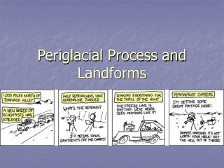
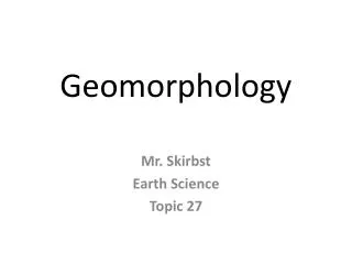
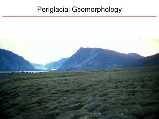
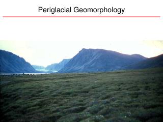
Periglacial Geomorphology. Periglacial Geomorphology. Periglacial : literally means “around glacial” - term introduced in 1909 to describe landforms and processes around glaciated areas.

E N D
Periglacial Geomorphology Periglacial: literally means “around glacial” - term introduced in 1909 to describe landforms and processes around glaciated areas. Periglacial environments: very cold climates in areas not permanentley covered with snow or ice, but in which permanently frozen ground (permafrost) occurs. Permafrost develops where the temperature profile at depth remains below 0°C throughout the year. Active Layer: zone of near-surface material that seasonally thaws and freezes.
Periglacial Environments: Permafrost • Permafrost: soil, regolith, and bedrock at a temperature below 0º C, found in cold climates. • Permafrost reaches a depth of 300 to 450 m near 70º N • Ground ice: water frozen in pore spaces • Active layer: surface layer that freezes and thaws with the seasons
Periglacial Environments: Active Layer The thickness of the active layer is a function of how deep thawing penetrates frozen ground. This will be controlled by: geothermal gradient (from below) atmospheric temperature (from above) vegetation, snow cover and organic litter can insulate the ground and form a buffer layer that can reduce the amplitude of seasonal temperature oscillations in the soil.
Ground Temperatures • Mean T increases with depth • Permafrost • Active layer to base of permafrost • Seasonal • Geomorphic work • Active layer
Types of Permafrost Continuous: Pervasive permafrost beneath the active layer broken only by open taliks (thawed ground) under lakes. Discontinuous: Continuity of permafrost broken by through-going taliks even in the absence of lakes. Sporadic: Isolated blocks of relatively thin permafrost - most common at margins of periglacial environments.
Discontinuous Permafrost: Local distribution • Absent beneath water • Absent beneath forest • Present beneath moss - hummocks
Extent of Permafrost • Continuous permafrost occurs in northern Russia, Canada, Alaska and Greenland. • Discontinuous permafrost extends to 50°N in Siberia and E. Canada. • Alpine permafrost occurs at very high elevations as far south at 30°N.
Freeze-thaw cycles • Weathering • Frequency • Intensity • Maximum • Mountains • South! • Minimum • North • W. coast
Frost Shattering and Identification of Glacial Trimlines Frost shattering of rocks is common in periglacial environments. Areas of extensive frost shattering can help identify nunataks (isolated ridgetops that extend above glaciers). Colorado Front Range Extent of periglacial landforms helps to constrain position of glacial trimlines (below which substantial glacial erosion occurred).
Strong Mechanical / Weak Chemical Weathering Thermal Expansion & contraction Frost Wedging
Frost (Ice) Wedges • Frost wedging • Expand/contract • Add water • Repeat • Upon warming, fill in with noncohesive sediment
Fossil Ice Wedges Cover sand (eolian)? • Ice wedges can fill with sediment or dust after they melt. • Evidence of former MAAT <-6°C Bkb (caliche) Preglacial soil
Patterned Ground The dynamics of seasonal freeze/thaw action in the active layer leads to a wild variety of patterned ground in periglacial environments. Polygons: Range from small features < 1m across to polygons over 100 m across. Ice-wedge polygons only form in presence of permafrost, but other types of polygonal ground can form in other environments. Circles: Characteristically rimmed by vegetation sorted - bordered by stones that tend to increase with size of the circle; typical dimensions are 0.5 to 3 m across. Stripes: Tend to form on steeper slopes with alternating stripes of coarse and fine material elongated downslope.
Ice Wedge Polygons Begin with cracking due to intense cold and thermal contraction. Networks of vertical ice wedges shape the polygons which occur below the active seasonal freeze-thaw layer. The visible surface formation is a result of the soil slumping above the ice wedges. May be a few meters to over 100 meters in diameter. Low centered if ice wedge is growing High centered if thawing is more prevalent causing stream channels along ice-wedges
Periglacial Slopes Periglacial landforms reflect: • Freeze-thaw cycles • Slope angle • Water saturation • Sediment size • Sediment supply • Snow/water/ice supply
Heave Settle Frost Heave • Heave • Moisture • Grain size • Creep • Saturation • Grain size • Slope
Frost Heave Fine Movement is a function of time and slope Fine material moves farther than coarser material Coarse Coarse Fine Transect across a flow lobe
Frost Heave Soils containing water expand when frozen, moving soil upward.
Patterned Ground: Sorted Circles Annual freezing and thawing sorts particles by size, producing rings of coarse fragments Produces polygons and rings, or sorted circles on low-gradient slopes and sorted stripes on steeper slopes.
Sorted nets • Like mud cracks • May be high-center or low (seasonal) • May be fine or coarse
Patterned Ground: Sorted Circles Thermal gradients across the active layer can drive pore water circulation that develops into discrete cells defined by zones of upwelling and downwelling. This process results in an actively convecting core of fine sediment and accumulation of coarse particles that are difficult to “subduct” at the downwelling zones.
Frost Boils Sorting and circulation • Fines in center (don’t step there!) • Stones around the margin
Tombstones Frost heave can lever tabular rock up into disconcerting positions…
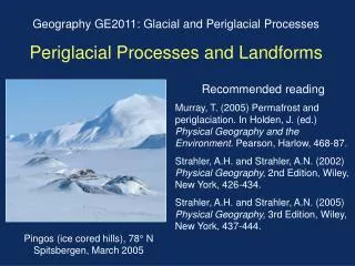
Pingos Conspicuous conical mound or circular hill, with a core of ice, found on tundra where permafrost is present. Form under initially unfrozen lakes (taliks).
Pingos If the lake is infilled with sediment and vegetation, or drained by drainage capture the insulation of the ground surface will increase and permafrost will advance from the sides and bottom of the talik - forcing water up into a zone of refreezing. Growth of this “pingo ice” pops the overlying sediment up and results in an ice-cored hill.
Thermokarst Characteristic landforms from thawing of ice-rich permafrost or the melting of massive ice blocks. It is characterized by an irregular topography, with irregular pits and depressions develop by thaw settlement.
Solilifluction: Geliflucition Solifluction Slow downslope movement of soil due in cold regions due to freezing and thawing. Frost heave: Vertical rise in position of material in a soil due to volume expansion that accompanies freezing of pore water. Results in net downslope movement because lifting by heave occurs perpendicular to the slope while back-dropping after thawing occurs vertically. Gelifluction Seasonal thaw of the active layer saturates surficial soil as the water cannot percolate into frozen soil below. Can result in flow of active layer on slopes as gentle as 2°, and results in terrace-like lobes.
Solilifluction: Geliflucition Lobes form where well-drained boulders trap finer sediment. Roll down hill like caterpillar track 2340±130
Solifluction Lobes Kyrgyzstan
Rock Glaciers • Transition between ice-glaciers and talus cones • Lobate rock masses downhill from talus • Often to treeline • Oriented due north
Rock Glacier Head Transitional to talus; coarse surface
Rock Glacier: Lobate Ridges Evidence of flow, arcuate ridges
Rock Glacier Toe Angle of repose; fine/frozen core
Rock Glacier Colorado
Environmental Problems of Permafrost • Human activities degrade the permafrost environment • Thermal erosion: surface layer removed, so the thaw extends deeper into the ground • Thermokarst: natural surface removed over large areas of tundra leads to ground subsidence that results in depressions and lakes — ground may subside and buildings may collapse • Buildings must be insulated • Pipelines must be placed aboveground
Alaska Pipeline • Continuous and discontinuous permafrost regimes • Active Tectonics
Effects of Climate Change in the Artic • By 2100, predicted rise in arctic temperatures of 4º C to 8º C may lead to: • Annual precipitation may increase by 20% • Active layer of permafrost will deepen over broad areas • Roads and pipelines disrupted • Populations of animals fluctuate • Hunting season shorter for native peoples • Boreal forest will migrate poleward and productivity will decline from drought, insects, disease, fire