Defining Precision and Accuracy in Cadastral Mapping
260 likes | 357 Vues
This presentation by Chief Cadastral Engineer Emilio J. Solano delves into the exact definitions and applications of precision and accuracy in the realm of cadastral mapping. The main topics covered include common definitions, differences between precision and accuracy, their application in mapping, and the significance of serving the tax-paying community. Understanding the nuances of single and double precision storage, high and low accuracy, and the importance of exactitude in measurements are key takeaways from this session. By highlighting the role cadastral mappers play in providing accurate and precise data for assessments and valuation purposes, this presentation sheds light on the essential work done in this field. The session also explores the implications of intention, ambiguity, and the meticulous application of concepts in creating reliable cadastral maps for various governmental agencies. Precision and accuracy are not just technical terms in this context; they represent the commitment to producing fair and correct valuations that directly impact taxpayers' expectations and trust in the system. Through real-world examples and accomplishments in the industry, attendees will gain insights into the vital role cadastral mappers fulfill and the continuous pursuit of precision and accuracy in their work.

Defining Precision and Accuracy in Cadastral Mapping
E N D
Presentation Transcript
Exactly defining Precision with all Accuracy As viewed by a cadastral mapper Presented by: Emilio J. Solano Chief Cadastral Engineer Mapping & G I S Services
Exactly defining Precision with all Accuracy Main Topics • Common Definitions • Differences • Application of concept • Who do we work for? • Questions
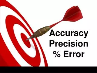
Common Definitions Precision: (1)The closeness of a repeated set of observations of the same quantity to one another. (2)The number of Significant digits used to store numbers.
Common Definitions • SINGLE PRECISION STORAGE: • 2.147 x 109 = 5m in a 1,000,000m extent DOUBLE PRECISION STORAGE: *9.007 x 1015 = >> 1m in a global extent more or less 0.25m in a 12,760,000m extent
Common Definitions Accuracy: The degree to which a measured value conforms to true or accepted values.
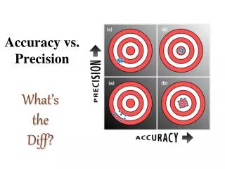
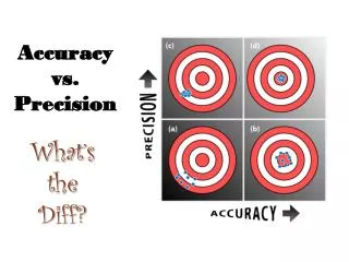
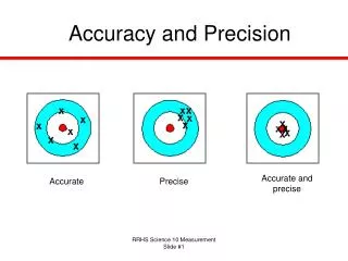
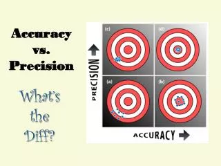
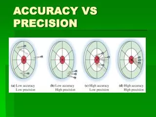
Common Definitions HIGH ACCURACY HIGH PRECISION HIGH ACCURACY LOW PRECISION
Common Definitions LOW ACCURACY HIGH PRECISION LOW ACCURACY LOW PRECISION
Common Definitions Exact:Capable of accuracy of detail; very accurate; methodical; correct. Exactitude:The quality of being exact; precise; accurate. From Latin exigere: To measure, to determine
Common Definitions Ambiguity:When an object may appropriately be assigned two or more values for a given attribute. Intention: • Determination to do a specified thing or act in a planned manner. • Anything intended or planned; purpose. • An instrument, such as a concept, for knowing and referring to a thing as it exists in the mind.
Differences A • Precision: It is a measure of exactness • Accuracy: It is a measure of correctness B
Application of concept The best outcome can be obtained by applying a single concept: • Take the best from the experts • Use it to do your job • Share the results
Application of concept Approach used byMapping: • Registered subdivisions / control points • Parcels (tax parcel base) • High resolution color orthophotos
Application of concept • DPW can provide new subdivisions registered to control points
Application of concept • The Assessor's assembles the tax parcel base (GIS layer)
Application of concept • A consortium can provide other elements
Application of concept 3,170 ft 5,910 ft 7,490 ft 2,230 ft
Application of concept • Now you have an ACCURATE product: • TAX PARCEL GEODATABASE That can be shared by: DPW - DRP - ROV - FIRE - SHERIFF And other local agencies
Who do we work for? Wrong! The Office of the ASSESSOR, and our primary function is to produce Assessor Maps. We work AT the Office of the Assessor FOR the TAX PAYERS!!!
Who do we work for? The TAX PAYER wants and expects: FAIRandCORRECTvaluations, which comes from us being able to choose between PRECISION andACCURACY
Who do we work for? ACCOMPLISHMENTS 2,600,000 assessments Over one TRILLION dollar roll 99.2% accuracy (SBE audit) Over 25,000 new parcels mapped AMB pages updated every 2 ½ hrs
Questions? Now... THIS is precision!