Bonnet Carre’ Spillway Viewer
200 likes | 366 Vues
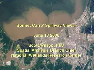
Bonnet Carre’ Spillway Viewer June 13 2008 Scott Wilson, PhD Spatial Analysis Branch Chief National Wetlands Research Center. Bonnet Carre’ Spillway Viewer. Spillway opened April 11, 2008 Multi-agency/organization partnership to display monitoring location data

Bonnet Carre’ Spillway Viewer
E N D
Presentation Transcript
Bonnet Carre’ Spillway ViewerJune 13 2008Scott Wilson, PhDSpatial Analysis Branch ChiefNational Wetlands Research Center
Bonnet Carre’ Spillway Viewer • Spillway opened April 11, 2008 • Multi-agency/organization partnership to display monitoring location data • USGS requested by the USACE to develop quick-response viewer: http://deltas.usgs.gov/BonnetCarre.aspx • Call went out to agencies/organizations to submit their monitoring locations and collection parameters for display on the Viewer
Phase 1: Quick Response • Linked on the MVN-USACE District homepage: http://www.mvn.usace.army.mil/ • LCA Science and Technology Program Data Management
Viewer went up within days of request from USACE • Location data posted as it is received • Tabular data with site coordinates processed into GIS format
Multi-Agency/Organization Effort • Contributing partners:
Viewer Functionality • Zoom in and click on a point for details about a site
Site Parameters • Site details include: • Coordinate information • Site name and/or ID • Lead agency or organization • Type of information being collected (i.e. water quality) • Collection frequency Sample
Other Site Information • Example: USGS NWIS Station • Click on an NWIS site • Click on link for “More Site Info”
Viewer Functionality • Choose a different display category: Data Type
Viewer Functionality • Choose a different display category: Frequency
Viewer Functionality • Download site data in tabular format with project description and methods
Phase 2: LCAST Viewer • Long-term data repository: http://lcast.sam.usace.army.mil/ • Can import Bonnet Carre’ web mapping service (wms)
LCAST Web Mapping Service • Click on the link at the top, “Servers Edit”, type in the WMS URL • Click “Retrieve Layers from Server” to view list of layers
LCAST Web Mapping Service • Click on layer “sites” to show all • Click “Submit Layers for Processing” • Click “Update Map to view sites on the LCAST Viewer
Next Steps • Agencies are collecting/checking monitoring data for quality assurance • Plans for making monitoring data public? • USGS NWIS, USGS LAWSC, LDNR, and CRMS – have websites with public access to data • LDEQ – compiling reports and will put them on their website • LSU - publishing their NSF funded monitoring efforts and data can be available upon request • LDWF - do not yet have set plans for making monitoring data publicly available, but would like to • ERDC – will compile tech notes and publish sturgeon monitoring data in a journal
Project Future • Bonnet Carre’ Viewer will continue throughout the summer • LCAST will be long-term repository for the location data • LCAST can also be repository for collected monitoring data if agencies want to make their data publicly available there
Future Data Collection • Didn’t see your data on the Viewer? • This is an on-going effort • Monitoring location data will continue to be added to the Viewer • Please send your data to: • Richard Boe at Richard.E.Boe@usace.army.mil and/or Molly Reif at reifm@usgs.gov