Download
1 / 50
510 likes | 681 Vues
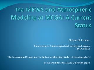
Ina-MEWS and Atmospheric Modeling at MCGA: A Current Status. Mulyono R. Prabowo Meteorological Climatological and Geophysical Agency INDONESIA The International Symposium on Radar and Modeling Studies of the Atmosphere 10-13 November 2009, Kyoto University, Japan. BMKG.

E N D
Ina-MEWS and Atmospheric Modeling at MCGA: A Current Status Mulyono R. Prabowo Meteorological Climatological and Geophysical Agency INDONESIA The International Symposium on Radar and Modeling Studies of the Atmosphere 10-13 November 2009, Kyoto University, Japan
BMKG Presentation Outline • Background • Major Programs • Modeling Status • Products
BMKG Background • Disasters in Indonesia are mostly earthquake and weather hazards related • Most prominent weather related disasters are droughts, forest fires, floods, landslides, strong winds, high waves, etc. • Ina-TEWS and Ina-MEWS are defined to the provision of timely and effective information that allows individuals exposed to earthquake or weather hazards to take action to avoid or reduce their being in risk and to prepare for effective response
BMKG Major Programs: • Ina-TEWS • Ina-MEWS
BMKG Ina-TEWS
BMKG Distribution of epicenters of earthquakes ≥ magnitude 5.0Period of 1976-2008, Southeast Asia – Indian Ocean
AEIC automatic earthquake data • Event: • Public ID bmg2009vxix • Preferred Origin ID Origin#20091108194416.038813.131479 • Preferred Magnitude ID NetworkMagnitude#20091108194430.236965.131558 • Description Sumbawa Region, Indonesia • Creation time 2009-11-08 19:42:59 • Origin: • Public ID Origin#20091108194416.038813.131479 • Date 2009-11-08 • Time 19:41:46.3 +/- 1.3 s • Latitude -8.24 deg +/- 4 km • Longitude 118.65 deg +/- 2 km • Depth 25 km +/- 17 km • Agency BMG • Status manual • Creation time 2009-11-08 19:44:16 • Residual RMS 1.1 s • Azimuthal gap 129 deg • 7 Network magnitudes: • MLv 6.73 +/- 0.26 9 preferred BMG • Mwp 6.72 +/- 0.12 6 BMG • Mw(Mwp) 6.89 +/- 0.40 6 BMG • mb 6.85 +/- 0.16 7 BMG • mB 7.22 +/- 0.18 7 BMG • Mw(mB) 7.20 +/- 0.18 7 BMG • M 6.92 9 BMG
BMKG Tsunami ? • Magnitude ≥ 7.0 RS • Depth ≤ 70 Km • In the sea • Trust Fault or Normal Fault
BMKG Ina-MEWS
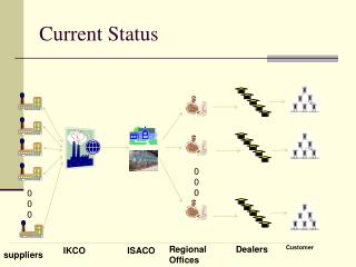
Design of Ina-MEWS MONITORING EQUIPMENT INTERNATIONAL METEOROLOGICAL AGENCY • Regional Disaster Reduction Center • Local Government • Local Mass Media (Electronic/ Printing) • Local Society Automatic Weather Sta. (176) 1 4 Data & Info row data Info (image) REGIONAL CENTER (29) 3a 2 LOCAL DISSEMINATION SYSTEM Info (local scale image) • PRESIDENTIAL OFFICE • NATIONAL DISASTER MANAGEMENT AGENCY • MINISTER • INSTITUTION INTERFACE • NATIONAL MASS MEDIA • SOCIETY Integrator / Software Weather Radar (19) row data REGIONAL PROCESSING SYSTEMS • NATIONAL DISSEMINATION SYSTEM • Channels • Type of Information • etc 5 BMKG JAKARTA 3b Data & info Satellite Ground Station (8) row data NATIONAL DISASTER PROCESSING CENTER
NWP PRODUCT (Data Grib) AWOS AWS End to End System of Ina-MEWS T C W C - JAKARTA • AVIATION • METEOROLOGICAL INFORMATION • SIGMET 6 METEO FRANCE ARPEGE MODEL AVIATION METEOROLOGICAL STATION AVIATION RADAR 7 TRANSMET 6 • MARINE METEOROLOGICAL INFORMATION • WAVES’ height • TC WARNING 7 CYCLONE MONITORING 0-10S; 90-125E MARINE METEOROLOGICAL STATION PORT OUTORITY SATELLITE BOM-AUSTRALIA TXLAPS MODEL PRESIDENTIAL OFFICE 3 NATIONAL DISASTER MANAGEMENT AGENCY 2 5 • METEOROLOGICAL INFORMATION FOR PUBLIC • HEAVY RAINFALL • FLOOD POTENCY • STRONG WINDS • WAVES’ HEIGHT • STORM AND CYCLONE INFORMATION 4 MEWS CLIENT INTEGRATOR 7 4 CMSS LOCAL GOVERNMENT REGIONAL CENTRE 1 MASS MEDIA 5 • METEOROLOGICAL INFORMATION FOR PUBLIC • - HEAVY RAINFALL • - FLOOD POTENCY • STRONG WINDS • WAVES’ HEIGHT • STORM AND CYCLONE INFORMATION 1 RADAR INSTITUTION INTERFACE OBSERVA SION DATA AWS/ARG NOTES: T C W C – TROPICAL CYCLONE WARNING CENTER MEWS – METEOROLOGICAL EARLY WARNING CENTER 7 INSTITUTION INTERFACE MASS MEDIA LOCAL DISASTER MANAGEMENT AGENCY GOVERNOR SATELLITE
NETWORK OF WEATHER RADAR AND GROUND SATELLITE RECEIVER BMKG Banda Aceh Medan Manado Ternate Padang Pontianak Balikpapan Palu Palangkaraya Sorong Biak Pekanbaru Palembang Jayapura Ambon Bengkulu Banjarmasin Makassar Bandar Lampung Jakarta Semarang Surabaya Marauke Denpasar Bima Kupang FY 2006 – 4 SITES FY 2006 – 1 SITE FY 2007 – 3 SITES FY 2007 – 2 SITES FY 2008 – 4 SITES FY 2008 – 1 SITE FY 2009 – 8 SITES FY 2009 – 4 SITES
BMKG RADAR IMAGE FOR JAKARTA 21 April 2009 16.00 LT RAINFALL INTENSITY STORM TRACK (POTENCY OF EXTREME WEATHER)
NETWORK OF AUTOMATIC WEATHER STATION ( 126 AWS ) BMKG
BMKG Modeling Status
BMKG Atmospheric Modeling • RegCM • HyBMG • Windwave • Precis • CCAM
BMKG Conformal-Cubic Atmospheric Model (C-CAM) • The Conformal Cubic grid • Using the Schmidt transform for regional forecasting • Multiple nesting techniques for downscaling • Topography and land-use datasets • 18 sigma levels (0, 40, 190, 470, 880, 1400, 2100, 2900, 3800, 4900, 6200, 7600, 9200, 11000, 13000, 16000, 20000, 26000, 35000m)
BMKG Conformal-Cubic grid • CCAM employs a Conformal-Cubic grid • Typically each face contains 48x48 grid points (i.e., a C48 grid) and 18 vertical sigma levels (total points = 48x48x6x18) Devised by Rancic et al., QJRMS 1996
BMKG Conformal-Cubic grid • The Conformal-Cubic (CC) grid provides CCAM with a number of advantages, including: • No singular points (e.g., the north or south pole). • No hard boundaries – CCAM is a global model. • The grid can be stretched for high resolution forecasts (e.g., 1km). • The stretched grid can be repositioned anywhere in the world.
BMKG Downscaling • The advantage of the stretched grid is the number of grid points is the same (i.e., the same RAM). • Only the ‘time step’ dt, needs to be reduced. 750km 200km 60km Schmidt = 1. Schmidt = 3.33 C48, 200km uniform grid spacing (dt = 36 min) CC48 grid can be stretched (use Schmidt transformation) to 60km stretched grid to also provide a regional forecast (dt = 20 min)
BMKG Features • 2-time-level semi-implicit hydrostatic (recently, also non-hydrostatic) • semi-Lagrangian horizontal advection with bi-cubic spatial interpolation • total variation diminishing (TVD) vertical advection • unstaggered grid, with winds transformed to/from C-staggered positions • before/after gravity wave calculations using reversible interpolation • minimal horizontal diffusion needed: • Smagorinsky style; zero is fine • Cartesian representation of all awkward terms: • calculation of departure points (McGregor, 1996, MWR) • advection or diffusion of vector quantities • indirect addressing keeps code simple • weak off-centering (in time) used to avoid semi-Lagrangian "mountain resonances“ • careful treatment of surface pressure and pressure-gradient terms near terrain • a posteriori conservation of mass and moisture • grid is isotropic
BMKG Physical parameterizations • cumulus convection: • new CSIRO mass-flux scheme, including downdrafts • evaporation of rainfall • GFDL parameterization for long and short wave radiation • interactive cloud distributions • derived prognostically from liquid water • gravity-wave drag scheme • stability-dependent boundary layer and vertical mixing with non-local option • vegetation/canopy scheme • 6 layers for soil temperatures • 6 layers for soil moisture (Richard's equation) • option for cumulus mixing of trace gases
BMKG Uniqueness • Can predict weather for up to 8 days • Easily relocatableanywhere • High forecast accuracy in targeted areas • operationally run at 1 km resolution over selected areas • Forecast system runs automatically • No 'hard' lateral boundaries - less artificial damping • only far-field nudging needed for higher resolution runs • Low computing power required. Approximate run times on standard Linux with a single3.2 GHz Intel Xeonprocessor: • 1 day at 60 km - 2 mins • 1 day at 8 km - 14 mins • Nearly linear speedup on parallel machines • 6 processor version used for operational forecasting
Wave Height H45 Model • The model was adopted from the CSIRO–Australia • Input : National Center for Environmental Prediction (NCEP) Global Forecast System (GFS ) • Resolution = input: 0.5 deg, output : 27 km (Indonesia), 9 km (Jawa) • Prediction = 8 days in advance per 3 hr, and 5 days per 1 hr • Input is downloaded automatically every day at 00 UTC and 12 UTC • Format file input & output: NetCDF • Run on a PC Cluster • Output is available on internal web of R&D - BMKG
Derivative Model H45 • Pre Processing • Download the NetCDF CCAM output • Use as H45.nc file • Processing • Running application H45 using time interval setting fit to CCAM output • Post Processing • Use Grads to display H45_out.nc • Display output as needed
Application H45 • Extract u and v wind parameter and soil (parameter soil is needed to differentiate sea and land) from CCAM output • Concert wind amplitude to wave height • Calculate wave dispersion according to its interval and period • Save output file in NetCDF format
Wave Height Conversion To convert wind speed to wave height • Graham Warren, Jean-Michel Lefevre, Basic Wave Theory Review, Bureau of Meteorology – Australia, Marine and Oceanography Section Meteo-France Toulouse France, 2008.
Wave Dispersion Horizontal section Vertical section Seterusnya sampai dengan interval ke n
Dispersion Algorithm redaman = bilangan riil antara 0-1 begin loop untuk setiap interval waktu loop untuk setiap magnitude angin U & V: loop Buffer2(x, y) = (Buffer1(x-1,y) + Buffer1(x+1,y) + Buffer1(x,y+1) + Buffer1(x,y-1)) / 2 - Buffer2(x,y) Buffer2(x,y) = Buffer2(x,y) * redaman end loop simpan Buffer2 tukar isi masing-masing Buffer end loop end loop Algoritm of 2 dimentional matrix of wave spatial dispersion
Result Prediction 25 September 2009 at 00.00 windwaves H45
Prediction 25 September 2009 jam 06.00 windwaves H45
Prediction 25 September 2009 at 12.00 windwaves H45
Prediction 25 September 2009 at 18.00 windwaves H45
Visually, the two models provide information that on 25th September 2009 high wave is over South China Sea east of the Philippines and north of Kalimantan. • Wave with significant height potentially occur over south west of Sumatera and in Indian Ocean • The two models show similarity pattern • Needs more verivicattion
SERVICES PRODUCTS USERS Meteorological Info. for Public Daily Weather Forecast Early Warning for Extreme Weather • Department of: • Transportation • Agriculture • Taurism • Maritime • Fishery • Public Work • Health • Defense • Nat.Logistic • NDMA • Media • Universities • Research Meteorological Info. for Aviation Met. Info. for Take off, Landing,Enroute Wave and Swell Surface Current Surface Wind (10 meter) Meteorological Info. For Maritime Fax, Email Web Telp Fire Index Smoke Trajectory F D R S Tropical Cyclone Location Cyclone Track METEOROLOGY SERVICES BMKG
BMKG Analysis of Wave Height on Accident of KM. Teratai PrimaMajene Sea of South Sulawesi10 January 2009 at 02.00 CIT Location of the Accident
Analysis of Wave Height on Accident of KM. Sumber Jaya Bangka Strait 17 February 2008 at 01.00 WIT BMKG BMKG Location of the Accident
TC Kirrily Satellite Image on 27th April 2009
TC Kirrily Satellite Image on 27th April 2009
BMKG Potency of Fire Vulnerability
Hot Spot 7 November 2009 BMKG Satellite NOAA 7 November 2009 detected 0 hot spot in Sumatera and 26 hot spots in Kalimantan (Central Kalimantan, South Kalimantan, East Kalimantan, and Malaysia)
BMKG Area Prediction for Flood Potency Vulnerability (10-day II : 11–20 January 2009) HIGHT POTENCY MEDIUM POTENCY
Summary • MCGA is still in the stage of operating and adopting radar and satellite and at the beginning stage of exploring / doing research • MCGA is still in the stage of utilizing NWP products and start exploring and developing NWP • Cooperation and capacity building are needed to maintain development the system and research in order to be able provide timely, accurate and effective information BMKG
BMKG Meteorological Climatological and Geophysical AgencyJl. Angkasa I No. 2, Kemayoran, Jakarta 10720, INDONESIAm.prabowo@bmg.go.id Thank you ….
References • Marcus Thatcher, CCAM General Introduction for New Users, Commonwealth Sientific and Industrial Research Organization, 2008. • Graham Warren, Jean-Michel Lefevre, Basic Wave Theory Review, Bureau of Meteorology – Australia, Marine and Oceanography Section Meteo-France Toulouse France, 2008. • http://www.ncep.noaa.gov • www.iges.org/grads • www.unidata.ucar.edu/software/netcdf • http://freespace.virgin.net/hugo.elias/graphics/x_water.htm