Introduction to Human Geography
220 likes | 414 Vues
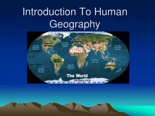
Introduction to Human Geography. Maps. Key Question:. Why do Geographers use Maps, and What do Maps Tell Us? . Map Appendix A Notes. Maps and their functions Map Scale Map Projections The Grid system Symbols on Maps. What are Maps and what are their functions. What can maps be used for?

Introduction to Human Geography
E N D
Presentation Transcript
Key Question: Why do Geographers use Maps, and What do Maps Tell Us?
Map Appendix A Notes • Maps and their functions • Map Scale • Map Projections • The Grid system • Symbols on Maps
What are Maps and what are their functions • What can maps be used for? • In what ways do maps distort?...Why? • How do maps show bias?
Reference Maps Show locations of places and geographic features Absolute locations What are reference maps used for? Thematic Maps Tell a story about the degree of an attribute, the pattern of its distribution, or its movement. Relative locations What are thematic maps used for? Two Types of Maps:
Thematic Map What story about the population of Korea in 1973 is this map telling?
Maps and their functions • Cartography = The art of map making • Reference Map = that used for navigating… ie. Road Map • Thematic Map: One used to illustrate a particular them • Mental Maps: Those that exist in one’s mind (Cognitive maps) • Topographic Maps… use lines to show contour.
Map Scale • Is the ratio between actual distance on the ground and the length given on the map • Which scale would show a smaller portion of the earth, 1/1,000,000… or 1/1,000,000? • Larger scale = more zoomed in • Why are different scales needed in mapping the world?
The Grid System • What function does the Grid System Serve? • What are the key aspects of the Grid system?
Grid stuff to know… • Parallel • Latitude • Equator (0º N. or S.) • Tropic of Cancer (N) • Tropic of Capricorn (S)… 23.5º • Arctic Circle • 0º - 90º N or S • Meridian • Longitude • Prime Meridian 0º E or W • International date line 180º E or W
Map Projections • Why are there different map projections? • Which ones do I need to know? • Azimuthal • Peters • Fuller / Dymaxion • Robinson • Mercator • What are the strengths and weaknesses? • For what are they most commonly used?
Map Symbols • Dots • Tones/shades/colors • Isolines • Symbols
Mental Maps: maps we carry in our minds of places we have been and places we have heard of. can see: terra incognita, landmarks, paths, and accessibility Activity Spaces: the places we travel to routinely in our rounds of daily activity. How are activity spaces and mental maps related?
Aspects of a Mental Map • Nodes • Edges • Paths • Districts • Landmarks
Discussion Questions • List as many type of maps and purposes for maps as you can.