GODAS Ocean Climate Modeling at NCEP
110 likes | 266 Vues
GODAS Ocean Climate Modeling at NCEP. David W. Behringer. Aquarius Workshop Silver Spring, MD November 29, 2011. The role of GODAS. Provide initial conditions for coupled SI climate forecasts Provide a means for monitoring the ocean climate. Climate Forecast System (CFSv1). CFSv2.

GODAS Ocean Climate Modeling at NCEP
E N D
Presentation Transcript
GODAS Ocean Climate Modeling at NCEP David W. Behringer Aquarius Workshop Silver Spring, MD November 29, 2011
The role of GODAS • Provide initial conditions for coupled SI climate forecasts • Provide a means for monitoring the ocean climate
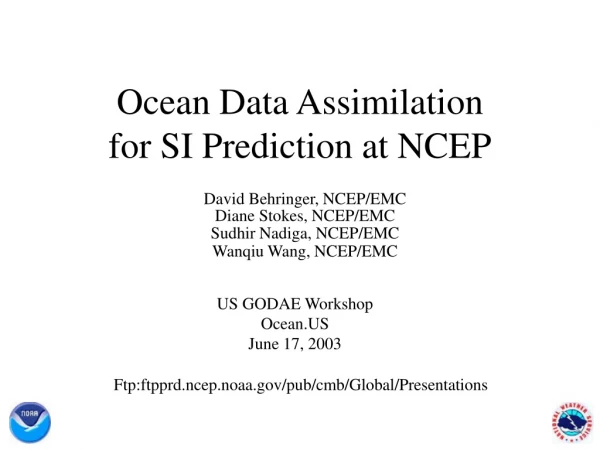
Climate Forecast System (CFSv1) CFSv2 In the CFSv1 the analyses that initialize the forecast are decoupled from the CFS. Climate Forecast System Ocean Model MOMv3 quasi-global 1ox1o (1/3o in tropics) 40 levels Atmospheric Model GFS (2003) T62 64 levels coupled daily via disk 6hr Atmospheric Model GFS T382 64 levels GDAS GSI 24hr 6hr Land Model Ice Mdl SIS LDAS Ice Ext Reanalysis-2 3DVAR T62L28 update of the NCEP-NCAR R1 GODAS 3DVAR XBT TAO etc Argo Salinity (syn.) (TOPEX/Jason-1) Ocean Model MOMv4 fully global 1/2ox1/2o (1/4o in tropics) 40 levels 6hr GODAS 3DVAR coupled in memory at 30 min In the CFSv2 the analyses that initialize the forecast are part of the system; each component gets its first guess from the CFS.
What might we hope to gain from an improved analysis of surface salinity?
Adding synthetic profiles to observed profiles increases the total by 57%. At 0.1 psu color resolution, there is no apparent alteration of the field. However, differences at the surface can exceed +/-0.25 psu. Biases in the synthetic salinity vary over time.
Equatorial salinity section in the Pacific (vertical bars show positions of time-series below). Assimilating Argo Salinity GODAS Salinity variability due to correlation with temperature. GODAS-A/S Salinity variability introduced by observations.
In the west, assimilating Argo salinity corrects the bias at the surface and the depth of the undercurrent core and captures the complex structure at 165oE. In the east, assimilating Argo salinity reduces the bias at the surface and sharpens the profile below the thermocline at 110oW. Assimilating Argo Salinity Comparison with independent ADCP currents. ADCP GODASGODAS-A/S
Summary • Salinity has a strong effect on Equatorial Pacific dynamics. • These effects are apparent in the surface isohaline layer and deeper down in the halocline. • It is reasonable to expect a near-term improvement in the near-surface equatorial isohaline layer. • It may also be possible ultimately to achieve improvement in the equatorial halocline through a better representation of surface salinity in the South Pacific subduction zone.