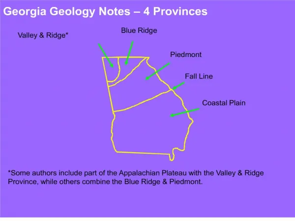
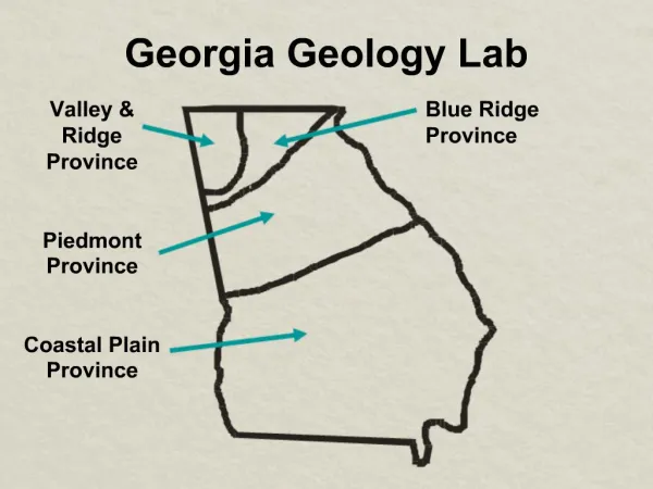
Georgia Geology Notes 4 Provinces
E N D
Presentation Transcript
1. Georgia Geology Notes � 4 Provinces
3. Valley & Ridge Province � (incl. Appalachian Plateau)
Cambrian � Pennsylvanian folded & faulted sedimentary rocks (544 to 286 m.y.)
Fracture and karst aquifers
Bounded by Cartersville and Great Smoky Mt. faults
Alternating anticlines & synclines, thrust faults
Cambrian � Ordovician sediments deposited on passive margin. Limestones, shales, sandstones.
Ordovician � Pennsylvanian � mostly clastics derived from rising highlands. Sandstones, shales, coal (Pennsylvanian Period)
4.
Taconic Orogeny �collision of Island Arc & Laurentia continent uplifted mountain range �Taconic Highlands�. Erosion of highlands produced a series of northwestward prograding �clastic wedges� (river deltas). Later orogenies rejunvenated uplands.
5. Georgia Geology Notes
6. Blue Ridge Province �
Precambrian � Devonian(?) igneous and metamorphic rocks � includes phyllites, schists, gneisses, metabasalts, other metavolcanics, marble, quartzite
Fracture aquifers, except for a few karst aquifers � Murphy Syncline
Highest topography in Georgia � 28 peaks > 4,000 ft.
9. Appalachian Mountains � a quick summary
Late Precambrian (600 m.y.) � Rifting of super- continent, opening of Iapetus Ocean.
Late Ordovician (450 my.) � Island arc collision with North America � Taconic Orogen y
Clastic wedges accumulate NW of Taconic
Highlands.
Late Devonian (410 to 380 m.y.) � Collision of Baltica and North America � Acadian Orogeny
Late Pennsylvanian (320 m.y.) � Collision of N.A. with Africa, final deformation & uplift. Stone Mt. and other granites emplaced � 300 m.y..
10. Fall Line � separates crystalline rocks of Piedmont from present extent of softer sediments of Coastal Plain.
Fall Line Cities � Columbus, Macon, Augusta
Marked by waterfalls and rapids.
Piedmont may have been partially covered by Eocene and Oligocene transgressions (sea level rises). Shoreline may have been low ridge of Brevard Fault Zone. Evidence eroded away.
11. Coastal Plain Province �
Late Cretaceous to Holocene (Recent) deposits at shoreline. Age � 70 m.y. - >10,000 yr.
Layered sediments, sands, clays, limestones.
Late Cretaceous sediments � mostly deltaic, including Providence Sand.
Paleocene � Oligocene sediments � mostly marine.
Miocene � Holocene � mostly continental deltaic, fluvial and alluvial sediments, except near coast.
Aquifers � uniform sediments, a few karst wells.
13. Resources Valley & Ridge Province
Oil & Natural gas (other states), Coal, Limestone, Barite.
Blue Ridge Province
Marble, minerals in pegmatites, Gold, Sulfide minerals (including Copper), Talc, Corundum.
Piedmont Province
Granite, minor Gold, Copper, Feldspar, minerals in pegmatites, minor Marble.
Coastal Plain
Limestone, Kaolin, Bauxite, Sand.
14. Review Valley and Ridge Province
Hard, compacted Paleozoic sedimentary rocks, folded and faulted during uplift of Appalachian Mts.
Blue Ridge Province
Hard, Precambrian to Paleozoic metamorphic rocks, folded, faulted, and metamorphosed during uplift of Appalachian Mts.
Piedmont Province
Hard, Precambrian to Paleozoic metamorphic and igneous rocks, similar to Blue Ridge Province.
Coastal Plain Province
Soft, uncompacted Late Cretaceous through Cenozoic sediments, layers inclined gently toward Atlantic Ocean and Gulf of Mexico (SW Ga.)
15. Groundwater Resources Valley & Ridge Province �
Fracture zones, karst features (caverns, enlarged fractures)
Blue Ridge Province �
Fracture zones, karst features (in Marble)
Piedmont Province �
Fracture zones
Coastal Plain Province �
More uniform aquifers (softer sand, limestone, karst features � Regional Floridan aquifer � Georgia and Florida.
16. Geology and Ecology Geologic structures affect topography and stream channel distribution
Rock types influence soil type
Soil type influences nature of rainfall infiltration
Soil type and topography influence vegetation types
Hardness of rock influences type of porosity and permeability and aquifer types
Topography influences climate and microclimate
Rock type influences chemistry and pathways of ground water