NOAA Emergency Managers Weather Information Network (EMWIN)
330 likes | 485 Vues
NOAA Emergency Managers Weather Information Network (EMWIN). EMWIN website - http://iwin.nws.noaa.gov/emwin/index.htm. What is EMWIN?.

NOAA Emergency Managers Weather Information Network (EMWIN)
E N D
Presentation Transcript
NOAAEmergency Managers Weather Information Network(EMWIN) EMWIN website - http://iwin.nws.noaa.gov/emwin/index.htm Fred Branski
What is EMWIN? • The Emergency Managers Information Network is a wireless, priority-driven computer weather data broadcast system providing timely watches, warnings, forecasts, other hydro-meteorological products, graphics and satellite imagery. • Uses NOAA’s GOES satellites and low cost user receive systems • Data content prioritized to needs of emergency managers • Satellite broadcast from GOES East and West • Rebroadcast in Pacific via PeaceSat4 • Rebroadcast on VHF radio in certain areas • Same bit stream available on Internet Fred Branski
What is EMWIN? • EMWIN provides rapid dissemination of: • Warnings < 2 minutes • Forecasts ~ 5 minutes • Graphics ~ 10 – 15 minutes • Imagery ~ 10 – 15 minutes • Other (as time permits) • In severe weather non-warning products may take longer Fred Branski
EMWIN – How it works • Data are collected from a variety of sources • NOAA/NWS Gateway, RTH Washington - GTS • NOAA Weather Wire • FTP • Internet • They are assembled at the EMWIN servers and: • Prioritized • Split into packets • Assembled into a data stream • The data stream is then sent to Wallops CDA (NESDIS) where it is: • Up-linked to satellite (GOES East & West) • The data stream is then available to be received by user stations • From here EMWIN products can be retransmitted by other methods • Up-linked to another satellite (ex. PeaceSAT4) • Transmitted via radio frequency • Sent on the Internet (BYTE Blaster) Fred Branski
Methods of Dissemination • Primary Wireless Methods • GOES East and West • PeaceSAT4 • Secondary Wireless Methods • Commercial Satellites • TV SAP channel • TV Vertical Blanking Interval (VBI) • Radio • Pagers • Internet Fred Branski
NOAA EMWIN Architecture GOES SPACE CRAFT EMWIN USERS NOAA/NWS GATEWAY SYSTEM RTH WASHINGTON – WMO GTS Primary Servers DEDICATED ANALOG LINE DEDICATED ANALOG LINE/T1 backup NOAA WEATHER WIRE SYSTEM WALLOPS CDAS BYTE BLASTER NETWORK Tertiary Backup EMWIN TRANSMIT NETWORK Backup Servers INTERNET CLOUD EMWIN INTERNET PUSH BITSTREAM NOAA WEATHER WIRE SYSTEM EMWIN FEEDSOURCES Fred Branski
5° Elevation 0° Elevation GOES East GOES West GOES Visibility Contours Fred Branski
GOES East and West footprint Fred Branski
Sample Forecast FPHW60 PHFO 201348 SFPHI STATE FORECAST FOR HAWAII NATIONAL WEATHER SERVICE HONOLULU HI 4 AM HST FRI JUN 20 2003 HIZ001>003-005-006-210200- STATE FORECAST FOR THE ISLANDS OF KAUAI-OAHU-MAUI-MOLOKAI-LANAI- 4 AM HST FRI JUN 20 2003 ...HIGH SURF ADVISORY CANCELLED AT 4 AM... .TODAY AND SATURDAY...MOSTLY CLEAR BUT FOR ISOLATED SHOWERS. HIGHS MID 80S. LOWS 70 TO 75. TRADE WINDS 15 TO 25 MPH. .EXTENDED FORECAST... .SUNDAY THROUGH TUESDAY...BECOMING PARTLY CLOUDY WITH SCATTERED WINDWARD SHOWERS MONDAY AND TUESDAY. HIGHS 80 TO 85. LOWS 70 TO 75. TRADE WINDS 15 TO 25 MPH WEAKENING TO 10 TO 20 MPH MONDAY AND TUESDAY. Fred Branski
Sample Warning WEHW40 PHEB 012158 TSUHWX TEST TSUNAMI BULLETIN NUMBER 003 TEST PACIFIC TSUNAMI WARNING CENTER TEST 11:58 AM HST 01 APR 2003 TEST TEST TEST TEST TEST TEST TEST TEST TEST TEST TEST TEST TEST TEST TEST THIS FOLLOWING BULLETIN IS FOR A CIVIL DEFENSE EXERCISE. TEST TEST TO: CIVIL DEFENSE IN THE STATE OF HAWAII TEST TEST SUBJECT: LOCAL TSUNAMI WARNING CANCELLATION BULLETIN TEST TEST TEST EFFECTIVE IMMEDIATELY, THE URGENT TSUNAMI WARNING ISSUED TEST FOR ALL COUNTIES IN THE STATE OF HAWAII IS CANCELLED. TEST TEST AN EARTHQUAKE HAS OCCURRED WITH THE FOLLOWING PRELIMINARY TEST PARAMETERS: TEST ORIGIN TIME - 11:40 AM HST, 01 APR 2003 TEST COORDINATES - 19.2 NORTH, 155.9 WEST TEST LOCATION - NEAR SOUTH KONA, BIG ISLAND TEST MAGNITUDE - 7.6 Fred Branski
Sample Image Fred Branski
Sample Graphic Fred Branski
EMWIN in the Pacific • GOES West broadcast • PeaceSAT4 broadcast • Currently PeaceSAT4 rebroadcasts the entire EMWIN data-stream • Some customized products added for the Pacific • Provides advance warning of Tsunami and Typhoons • Testimonials received have reported that after a severe event the only weather system still functioning is EMWIN • Many island nations already use EMWIN to save lives and property Fred Branski
Why it works so well • The equipment is inexpensive • An entire turnkey system costs as little as $1k • System needs little to no infrastructure • Easy to run on a laptop • Ex. Solar powered version exists • Signal is “Weather Proof” due to L-Band transmission • Equipment is relatively compact and is very rugged • The Data-stream is free, repeatable and can be customized for local retransmission • EMWIN is non-proprietary • Multiple inexpensive software display packages are available • A large and knowledgeable user community to help monitor performance and answer user questions (EMWIN user list) • Transmission covers 3/4 of world surface Fred Branski
EMWIN current specs • Frequency on GOES - 1690.725 MHz • Modulation – Dual Frequency Shift Keying (DFSK) • Speed - 9.6 kbps • Power – EIRP = 51 dBmi EMWIN website - http://iwin.nws.noaa.gov/emwin/index.htm Fred Branski
Why is change necessary? • EMWIN shares spare bandwidth in the existing WEFAX channel • The EMWIN/WEFAX broadcast was allowed to exceed UN ITU authorized power level by special exception • NESDIS GOES N/Q series will use all of former WEFAX channel bandwidth for new Low Rate Information Transfer (LRIT) broadcast • Must move EMWIN to its own channel, at reduced power Fred Branski
What must change? • With advent of GOES-N/P satellite generation • Broadcast power must be reduced to comply with ITU power limits: • From: 51.0 dBmi (minimum EIRP) • To: 44.8 dBmi (minimum EIRP) • Frequency must change: • From: 1690.725 MHz • To: 1692.700 MHz • Modulation must change to partly offset reduction in broadcast power: • From: DFSK modulation • To: OQPSK modulation • Forward Error Correction (FEC) coding added to offset balance of power reduction and allow increased data rate Fred Branski
When Could Changes Occur? • 2005 - 2011 • GOES-N launch • Official date: March 31/April 1 2005 • Unofficial date: Not Earlier Than (NET) July 2005 • GOES-N Operational • First broadcast of new EMWIN-N service: • As early as 6-8 months after GOES-N launch • As late as early 2011 • Depends on fuel usage and subsystem health for both GOES 11 and GOES 12 Fred Branski
GOES N/P EMWIN Transition Objectives • Listen to users & vendors • Keep them informed of changes • Prepare and update a transition plan • Provide adequate time for changes to be made • Establish an overall system design • Develop a proof-of-concept prototype receiver • Release schematics and operating software to industry for individual design and production Fred Branski
Informing & Listening • EMWIN website - http://iwin.nws.noaa.gov/emwin/index.htm • EMWIN user groups • Local outreach programs • Via Warning Coordination Meteorologists in Weather Forecast Offices • Special conferences • User-vendor conferences • International forums and meetings Fred Branski
Informing & Listening cont’d • Provided latest information on transition planning • Demonstrated feasibility of a 9.6 kbps prototype software-defined receiver design • Users and vendors urged: • Increasing the system data rate to 19.2 kbps • Keeping transition costs as low as possible • Making EMWIN data stream available as part of LRIT Fred Branski
Informing & Listening cont’dUser-Vendor Recommendations • User & vendor recommendations accepted by NWS and NESDIS • NESDIS has determined technical feasibility of 19.2 kbps data rate • Prototype software-defined receiver design being amended & expected to be ready for testing in January, 2005 • Design will incorporate new features intended to lower costs for commercial vendors • Planning in progress to include EMWIN data stream in LRIT broadcasts Fred Branski
Transition Planning • NOAA joint NWS/NESDIS co-ordination team • Formed to plan the transition activities • NWS is focal point for public contact • NESDIS responsible for prototype receiver development and testing • Initial transition plan approved in December, 2003 • Updated version now in preparation Fred Branski
Overall System Design • Existing EMWIN on GOES I/M • 9.6 kbps data rate • Dual frequency shift keying (DFSK) • No forward error correction • Changes for GOES N/P • Proposed link budget on NWS EMWIN web site • Increased data rate to 19.2 kbps will require changing modulation scheme to offset quadrature phase shift keying (OQPSK) • Reduced broadcast power will require forward error correction • Convolutional rate ½ + Reed-Solomon FEC Fred Branski
Prototype Receiver Design • Key design concepts • Minimum dish antenna size will be retained at one meter • Hardware implementation scheme for intermediate frequency conversion • Use of OQPSK and forward error correction to compensate for lower power level • Software-defined receiver for demodulation and decoding functions • Capable of receiving either existing GOES I/M signal or new GOES N/P signal Fred Branski
Prototype Implementation Schedule • 2004 • Design and build 19.2 kbps prototype • Begin factory testing of prototype • 2005 • Factory testing complete • Bench testing of prototype at NOAA facility • Live testing of prototype using GOES-N satellite • GOES-N stored on-orbit • Release 19.2 kbps spec and design to industry for mass production of EMWIN station Fred Branski
NOAAInternational Satellite Communication System(ISCS) ISCS website - http://weather.gov/tg/iscscvr.html Fred Branski
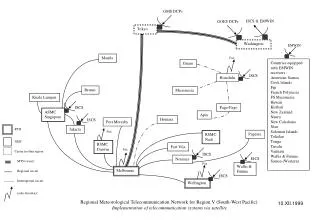
The International Satellite Communications System (ISCS) • Supports ICAO/WMO requirements (as a servicing World Area Forecast Center - WAFC). • Global coverage • ISCS from 105 degrees east longitude to 65 degrees east longitude (covering the Pacific Ocean, Atlantic Ocean, North America, Central America, South America, and the Caribbean). • Remainder of the world coverage supported by United Kingdom WAFC through their satellite broadcast system called SADIS (primarily covers the European, Asian, and African continents as well as the Indian Ocean). Fred Branski
ISCS RMTN in RA-IV All users committed to sending and receiving data • Shared space segment on communications satellite • NOAA pays for half of space segment costs • Half of space segment costs are shared between the other users • In RA-IV there are 32 possible participants costs would vary with participation • Billing is now on annual basis Fred Branski
Going Two-way • Possible after initial installation of ground equipment • Requires changes in satellite dish feedhorn • Requires changes in connecting hardware • Will be at the expense of the site Fred Branski
Benefits to Two-way Systems • New workstations have built-in capacity to send and receive data • Increased data exchange and opportunities to form partnerships • Potentially lower cost for a shared space segment • Increased data transmission speed, reliability, and access among two-way users Fred Branski
Questions? Fred Branski