Interpreting Hydrology from Soil Morphology
Interpreting Hydrology from Soil Morphology. Rationale Soil and water history of a landscape can be interpreted from soil morphology and stratigraphy. Objectives. Examine soil morphology with respect to temporal and spatial distributions of soil water.

Interpreting Hydrology from Soil Morphology
E N D
Presentation Transcript
Interpreting Hydrology from Soil Morphology RationaleSoil and water history of a landscape can be interpreted from soil morphology and stratigraphy.
Objectives • Examine soil morphology with respect to temporal and spatial distributions of soil water. • Examine soil participates and salts with respect to temporal and spatial distributions of soil water. • Examine mineralogical relationships of soil water distributions. • Use all of the above to interpret temporal and spatial distributions of water in soil landscapes.
What do you see? Observation interpretation 1 2 3 Climate Hydrology Bk Marbut series photo
Argillic Horizon Hydrology • Distinct Dry Season or much Na • Dispersion on wetting & infiltration (recharge) • Downward flow in large pores (flowthrough) Flow by Fg • Ped withdrawal of water (discharge) Flow by Fm MATRIC FLOW IS FROM COARSE TO FINE PORES.
A E Btg Addition Subtraction Translocation Transformation Bt formation E formation 3 processes here Redox (2); eluvial clay g gley processes LANDSCAPE CONDITIONS NATURAL VEGETATION CROP LAND LATERAL FLOW FERRIC IRON TO FERROUS IRON IS ENDOTHERMIC (REQUIRES EXTERNAL ENERGY).
Salt concentrates at soil surface!Basin and Range region of Nevada EVAPORATIVE DISCHARGE MATRIC FLOW MOVES FROM WET AREAS TO DRY AREAS – BE THESE UP, DOWN OR LATERALLY. RECHARGE
Soil structure—the aggregation of the sands, silts and clays into larger units. Porosity—The Voids: Are they connected, small, large—BIG DIFFERENCES In Ksat Photo RD Hammer
LATERAL FLOW MAXIMIZED by LEAST RESTRICTIVE LAYER ANISOTROPYUneven downward flow LOAM BD 1.2 gm/cm3 INFILTRATION FLOW DIRECTION SAND BD 1.2 gm/cm3 DENSE TILL BD 2.0 gm/cm3 DOWNWARD FLOW IS CONTROLLED BY THE MOST RESTRICTIVE LAYER
MATERIAL SEGREGATION by WATER Mn concretions Fe concretions Direction of water movement Photos RD Hammer
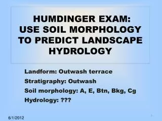
OUTWASH TERRACE; HIGH WATER TABLE EVERY SPRING; 94% SAND OR COARSER, HIGH SODIUM & pH; white Bk is Protodolomite; note the Btn horizon. E Btn pH 9.1 Bk 50% clay 2Cg 94% sand 32 Photo JL Arndt THE PARTICIPANT WILL DESCRIBE AND EXPLAIN THE DEVELOPMENT OF THIS SOIL, ESPECIALLY FOCUS ON THE WATER DYNAMICS. STIRUM: COARSE-LOAMY, MIXED, SUPERACTIVE, FRIGID TYPICNATRAQUOLL
Concepts to use in your answer • Matric flow a) wet to dry; b) frost; • Saturated flow above and below water table; • Formation of a Bt, Btn and Bk in terms of hydrology; • Dispersion; translocation; reverse translocation; • Braided stream; terrace; • Evaporite sequence – alkaline branch • Redoximorphic features
A Big Question: Where is the WATER TABLE for each season?
DETERMING WATER TABLEPOSITION – SUMMER Moderate Infiltration Form Upper Soil Horizons Summer - E, Btn horizons form - Occasional thunder storms provide rain - Explosive plant growth + ET - Bk horizon forms above WT (Evap. Discharge) - Mid-level WT falls through Summer
DETERMING WATER TABLEPOSITION – WINTER Frozen Soil Behaves A Bit Like A Dry Soil MATRIC FLOW IS FROM WET TO DRY SOIL Winter - Snowpack & Cold limit H2O inputs - Very low WT - Deeply frozen soils behave as dry soils - Frost heave churns lower portion of profile - Capillary action drives soil water up - Some Bk horizon activity - No plant growth
DETERMING WATER TABLEPOSITION – SPRING Heavy Spring Rains Recharge Aquifer Spring - E, Bt horizons form - Cloudy, cool, wet weather - Moderate plant growth + ET - High rainfall inputs recharge groundwater - Highest WT of the year - Throughflow dominates
Determining Water Table Position Moderate Infiltration Helps Form Upper Soil Horizons SUMMER WINTER SPRING
SUMMER WINTER SPRING Winter - Snowpack & Cold limit H2O inputs - Very low WT - Deeply frozen soils behave as dry soils - Frost heave churns lower portion of profile - Capillary action drives soil water up - Some Bk horizon activity - No plant growth Spring - E, Bt horizons form - Cloudy, cool, wet weather - Moderate plant growth + EVT - High rainfall inputs recharge groundwater - Highest WT of the year - Throughflow dominates


![Oil From [the] Soil](https://cdn1.slideserve.com/1646767/oil-from-the-soil-dt.jpg)
![Oil From [the] Soil](https://cdn1.slideserve.com/1940796/oil-from-the-soil-dt.jpg)