Celestial Coordinate Systems K-12 Coordinate Curriculum
550 likes | 589 Vues
Explore celestial coordinate systems of the night sky, from spherical to horizon systems, latitude and longitude, and equatorial tracking methods.

Celestial Coordinate Systems K-12 Coordinate Curriculum
E N D
Presentation Transcript
Celestial Coordinate Systems K-12 Coordinate Curriculum Karen Lancour Chandra Resource Agent and Mark Van Hecke Chandra Resource Agent
Night Sky • Sky appears as inside of a very large sphere • 88 constellations • Important to specify positions of objects in the sky in relation to one another • Coordinate systems
Appearance of the Night Sky • 3-dimensional space appears as a 2-dimensional flat surface • Like a photograph or drawing • Different methods are used to determine distance from earth
Spherical Coordinates • Geographic & Celestial systems are spherical coordinate systems • 2-dimensional systems • Fundamental Plane –Equator • Polar Axis • North & South Poles
Celestial Sphere • Huge, hollow, imaginary sphere • Infinite radius • Appears to rotate east to west • Earth is actually rotating west to east • Celestial Equator • North Celestial Pole and South Celestial Pole
Coordinate Systems – Different Reference Planes • Major Coordinates Systems • Different reference planes for Celestial Sphere • North-South Axis perpendicular to reference plane • Developed to facilitate different perspectives
Coordinates – Angular Measurements • Angular measurements • Latitude-like coordinates • Longitude-like coordinates • Zero point of longitude • Local meridian
Latitude and Longitude • Circles of latitude • Same latitude • Meridians of longitude • Same longitude • Zero point or prime meridian
Geographic System • Equator is 0 degrees • North Pole is 90 degrees N. • South Pole is 90 degrees S. • Greenwich meridian • 0 to 180 degrees east • 0 to 180 degrees west
Geographic Coordinates • 360 degrees of arc in a circle • Each degree has 60 minutes of arc • Each minute of arc has 60 seconds of arc
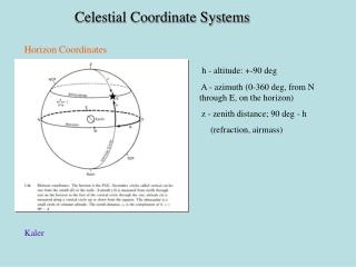
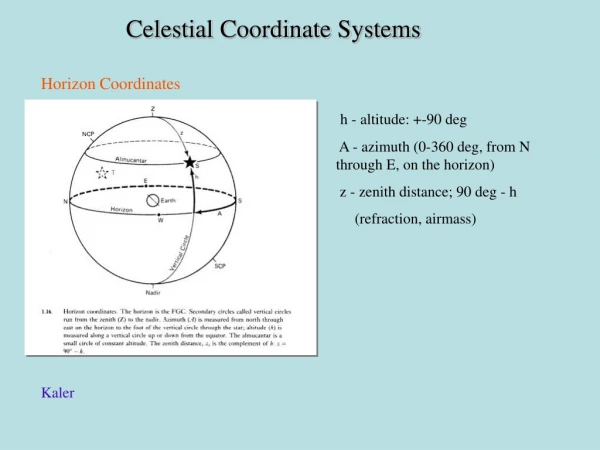
Horizon System • For Personal Observation • Plane of local horizon • Zenith – 90 degrees above horizon • Nadir – 90 degrees below horizon • Horizon affected by the latitude of the observer.
Horizon System - Alt-AZ • Altitude – angle of object above the horizon • Azimuth – angle of object around the horizon clockwise from north
Horizon System - Alt-az • Altitude = 0 to 90 deg • Azimuth = 0 to 360 deg • North point defined • North = 0 deg • East = 90 deg • South = 180 deg • West = 270 deg
Horizon System • Observer’s view • Geography dependent • Altitude of NCP = latitude of observer. • Time and Season dependent • Same object has different coordinates at different times
Local Horizon – North Pole • View from North Pole • Zenith is North Celestial Pole • Local horizon is parallel to Celestial Equator • Stars rotate parallel to horizon (celestial equator) • Stars never rise and set
Local Horizon – Fairbanks • View from Fairbanks • Altitude of NCP equals latitude of observer. • Stars move parallel to the celestial equator • As one moves south, the NCP moves away from zenith toward the north point of horizon
Local Horizon - Seattle • View from Seattle • Stars rise in east and set in west • NCP moves further away from Zenith • Arc of star movement above horizon gets steeper
Local Horizon – Los Angeles • View from Los Angeles • 34 deg latitude • NCP at 34 deg above the horizon and 56 deg from zenith • All observers on 34th parallel see the same star path • Star path is steeper
Local Horizon – Equator • View from equator • NCP is parallel to local horizon • Celestial Equator is perpendicular to local horizon • Zenith is on celestial equator • Stars rise and set perpendicular to horizon
Local Equatorial System • Stars rise in east and set in west • Motion of each star = parallel of declination on the Celestial Sphere • Celestial Equator is half way between NCP and SCP • Related to sidereal “star” time • Used to track motion of stars
Local Equatorial System “HA-dec” • Used to track objects • Latitude (Declination) is from the Celestial Sphere • Longitude uses Hour Angle • Follows star path from east to west • Is still time dependent at local meridian
Hour Angle • Time before and after star reaches zenith of its path
Equatorial System “RA-dec” • Used to catalog objects • Celestial Sphere • Celestial Equator • NCP and SCP • Declination (latitude) • Right Ascension (longitude) • Vernal Equinox
Declination • Angle above Celestial Equator • Parallels of Declination • CE = 0 deg • NCP = 90 deg • SCP = - 90 deg
Right Ascension • Hour circles or “meridians” • Equator = 360 arc deg circumference • Measured as hours (24 hours) • 1 hr = 15 arc degrees • Counterclockwise • 0h = vernal equinox
Ecliptic From Earth, • Sun ‘s apparent path • Inclined 23.5 deg to Celestial Equator • Vernal Equinox • Autumnal equinox • Winter Solstice • Summer Solstice
Ecliptic System • Earth revolves around sun = ecliptic • Ecliptic is fundamental plane • Axis of rotation • North Ecliptic Pole • South Ecliptic Pole • Planets have similar paths around sun
Ecliptic System & Planets • Used to study solar system • Except for Pluto at 17 degrees • Orbital Inclination within 7 degrees of Ecliptic
Zodiac Constellations • As earth revolves, sky appearance changes. • Constellations around ecliptic called Zodiac
Galactic System • Study Milky Way and beyond • Plane of Galaxy • Inclined about 63 deg to Celestial Equator
Galactic System • Fundamental plane = plane of Milky Way • Galactic Equator • North Galactic Pole • South Galactic Pole • Center of Galaxy
Galactic Coordinates • Galactic Latitude • NGP = 90 deg • SGP = -90 deg • Galactic Longitude • Counterclockwise • 0 to 360 deg • 0 = center of our galaxy
Coordinate Curriculum K-13 • Elementary Activities • Middle School – Junior High Activities • Senior High Activities • Aligned to National Standards • Involve science, geography, math, language arts, art, problem-solving • Introductory, skill-development, and assessment activities
Chandra Related to 1. Chandra Classroom-ready activities as Stellar Evolution, Variable Stars, Electromagnetic Spectrum, Imaging for Junior and Senior High 2. ds9 and Visual Observatory 3. Chandra Sky Map
Science Olympiad Related to 1.Elementary Science Olympiad events in Starry, Starry Night and Map Reading 2.Reach for the Stars and Road Scholar for Division B 3.Astronomy and Remote Sensing for Division C 4.Trial events as Global Positioning Systems
Tools of Astronomy • 3-d models, globes, grids, star maps, charts, graphs, quadrant, astrolabe, cross-staff, pinhole protractor, parallax, hand angles • binoculars, telescope, star lab, planetarium • Computer technology as Chandra Sky Map, ds9, Remote Sensing, GPS, Sky Map programs • Coordinates, measurements, angles, relative positions, times, navigation
Sample Activity • Chandra’s Stellar Evolution poster recently in the Science Teacher magazine • Map projections • Coordinate grids • Problem-solving
Map Projections • Attempts to represent sphere on flat map • Always some distortion • Types to emphasize specific regions of sphere
Whole Sky (Aitoff) Projection • Whole sky projection is popular with astronomers • Projections for Equatorial, Ecliptic, or Galactic Systems
Mercator - Equatorial Region • Shows the regions near the equator • Less distortion when put on a flat surface • Regions north and south of equator
SC001 Equatorial Region • Using Equatorial (RA-dec) System
SCOO1 - Declination • Declination (latitude-like) from +60 deg above to -60 deg below celestial equator. • Degrees, minutes, and seconds of arc