Citrus County Located in west central Florida
280 likes | 513 Vues
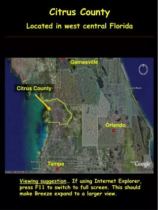
Citrus County Located in west central Florida. Gainesville. Citrus County. Orlando. Tampa. Viewing suggestion … If using Internet Explorer, press F11 to switch to full screen. This should make Breeze expand to a larger view. Citrus County. Gulf of Mexico. Withlacoochee River.

Citrus County Located in west central Florida
E N D
Presentation Transcript
Citrus County Located in west central Florida Gainesville Citrus County Orlando Tampa Viewing suggestion… If using Internet Explorer, press F11 to switch to full screen. This should make Breeze expand to a larger view.
Citrus County Gulf of Mexico Withlacoochee River
Citrus County Geological Characteristics Three significant geological regions
Citrus County Geological Characteristics Gulf Coastal Lowlands • Low energy coast dominated by freshwater swamps on the eastern edge and salt water marshes on the western edge. • Eastern portion of coastal lowlands range from 10 to 70 feet above sea level.
Citrus County Gulf Coastal Lowlands • Soils underlain by bedrock at 20” or less. • Daily tidal inundation. • Cordgrass and saltgrass typical.
Citrus County Geological Characteristics Brooksville Ridge • Elevations range from 70 to 200 feet above sea level. • Composed of a limestone core overlain by clayey sands and sandy clays with the clayey material overlain by Pleistocene sands.
Citrus County Geological Characteristics Tsala Apopka Plain • Elevations range from 35 to 80 feet. Flood plain for Withlacoochee River with a chain of lakes separated by peninsulas and islands of higher elevation. • Alluvial deposits of variable thickness cover limestone surface.
Locations of Soil Evaluations Soil 2 Soil 1
Soil 1: Landscape • Example of cleared land in Brooksville Ridge area. • This picture was taken at a top of a hill looking down slope. In the horizon is another hill. • I included this to demonstrate the significant elevation changes over short distances in the Ridge area. These “abrupt” elevation changes are significant for Florida.
Soil 1: Morphology Ap – 0-9 cm: 10YR 4/2 sand; abrupt boundary; weak, massive, loose. No redox features observed. 9 cm
Soil 1: Morphology Bw1 – 9-25 cm: 10YR 5/4 sand; clear boundary; structureless, single grained, loose. No redox features observed. 9 cm 25 cm
Soil 1: Morphology Bw2 – 25-100 cm: 10YR 6/6 sand; gradual boundary; structureless, single grained, loose. 9 cm 25 cm 100 cm
Soil 1: Morphology Bw3 – 100-200 cm: 10YR 7/6 sand; structureless, single grained, loose. No redox features observed. 9 cm 25 cm 100 cm 150 cm
Soil 1: Profile Properties and Interpretations Ap 9 cm Infiltration Rate : High, 7.5 cm per hour (sand). Available Water: Very low. Hydraulic Conductivity: High. Soil Wetness Class: Class 1 - Not wet above 150 cm. Dwellings with Basement: Slight limitations. Septic Tank Absorption Field: Slight limitations. Local Roads and Streets: Slight. Bw1 25 cm Bw2 100 cm Bw3 150 cm
Soil 1: Site Characteristics Ap 9 cm Position of Site : Upland. Parent Material: Alluvium. Soil Slope: 2 to 6% - gently sloping. Surface Runoff: Slow – gently sloping with high infiltration. Erosion Potential: Low – gentle slope and high infiltration. Bw1 25 cm Bw2 100 cm Bw3 150 cm
Soil 2: Morphology Ap – 0-13 cm: 10YR 4/1 sand; abrupt boundary; weak, massive, loose. No redox features observed. 13 cm
Soil 2: Morphology EA – 13-40 cm: 10YR 5/2 sand; clear boundary; weak, massive, loose. No redox features observed. 13 cm
Soil 2: Morphology E – 40-82 cm: 10YR 6/1 sand; clear boundary; weak, massive, loose. Depleted matrix. No redox concentrations. 13 cm 40 cm 82 cm
Soil 2: Morphology Bh1 – 82- 106 cm: 10YR 4/3 sand; clear boundary; weak, subangular blocky, very friable. No redox features observed. 13 cm 40 cm 82 cm 106 cm
Soil 2: Morphology Bh2 – 106 - 150 cm: 10YR 5/4 sand; clear boundary; weak, massive, very friable. No redox features observed. 13 cm 40 cm 82 cm 106 cm 150 cm
Soil 2: Morphology Bh2 – 106 - 150 cm: 10YR 5/4 sand; clear boundary; weak, massive, very friable. No redox features observed. 13 cm 40 cm 82 cm 106 cm 150 cm
Soil 2: Profile Properties and Interpretations Ap Infiltration Rate : High, >7.5 cm per hour. Available Water: Very low – all sand Hydraulic Conductivity: High - sand Soil Wetness Class: Class 4, wet between 25 – 50 cm. Dwellings with Basement: Severe, <50 cm to SHWT. Septic Tank Absorption Field: Severe, <100 cm to SHWT. Local Roads and Streets: moderate, 25 - 50 cm to SHWT. 13 cm E1 40 cm E2 82 cm Bh1 106 cm Bh2 150 cm
Soil 2: Profile Properties and Interpretations Ap 13 cm Position of Site : Upland. Parent Material: Alluvium. Soil Slope: 2 to 6%. Surface Runoff: Slow. Erosion Potential: Very low. E1 40 cm E2 82 cm Bh1 106 cm Bh2 150 cm
References State of Florida. Florida Geological Survey. Geology of Citrus County. Tallahassee, 1984.