The Impact of Geography on Mesopotamian Civilization and European Landforms
240 likes | 366 Vues
This overview discusses the importance of Mesopotamia, recognized as the "cradle of civilization," highlighting key cultures such as the Sumerians, Babylonians, and Assyrians. Explore how physical geography, including mountains, rivers, and seas, influenced settlement patterns, culture isolation, and trade in both Mesopotamia and Europe. We examine the unique landforms of Europe, such as fjords, peninsulas, and polders, illustrating their effects on economic activities and ways of life throughout history.

The Impact of Geography on Mesopotamian Civilization and European Landforms
E N D
Presentation Transcript
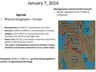
January 7, 2014 Agenda • Mesopotamia and the Fertile Crescent • Widely regarded as the “cradle of civilization,” Sumerians (3500 to 2300 B.C.), go from hunter-gatherer society to agricultural (farming) Physical Geography – Europe Mesopotamia is Greek for “land between two rivers.” Sumerians (3500 to 2300 B.C.), the developers of writing Babylon (1792-1595 B.C.), led by Hammurabi, who developed the eye-for-an-eye legal code Assyria(883-612 B.C.), the masters of warfare and the first people to effectively use chariots. The culture of Mesopotamia spread to Palestine, Greece and Rome and became components of our culture today.
Warm-Up • What type of landforms might isolate cultures from each other?
Current Physical and Political Map of Europe -Layers of Information
Mountains • Alps • Apennine • Balkan • Pyrenees • Serve as a barrier • Isolate cultures
Peninsulas • Peninsula – a piece of land nearly surrounded on all sides by water • Northern • Scandinavian • Jutland • Southern • Iberian • Italian • Balkan • How would being surrounded/near water affect way of life?
Oceans and Seas • North Sea • Bay of Biscay • Mediterranean Sea • Adriatic Sea • Baltic Sea • Norwegian Sea • Black Sea • Aegean Sea • English Channel
Rivers Benefits • transport goods between interior and coastal cities • Aided movement of ideas
Danube • Touches 9 countries • Connects to central Europe to Russia and Middle East
Rhine River • Connects Central Europe to England
Northern European Plain • One of World’s most Fertile Regions • Flatness, provided an easy entrance for invaders throughout History.
Unique Features • Fjords • Steep valley’s carved by Glaciers and then filled with seawater • Polders • Land in the Netherlands that is drained and dried • Canals • City of Venice made up of Islands • Boat is primary source of travel
Zuider Zee • The Dutch built a dike across its entrance. • It gradually became a freshwater lake. • Allowed Dutch to reclaim once flooded land.
Zuiderzee - Video (7 min.) http://www.youtube.com/watch?v=6v4yjEmrqRg
Resources • Coal and Iron • Large supply • Peat – partially decayed plant matter used in Ireland burned as an energy source • Oil • Found in the North Sea • Land • 33% Suitable for Agriculture • World average is 11%
Major Factors that influence climate in Europe • Ocean Currents • North Atlantic Drift • Warm water current that moderates the temperature • Winds • Mistral – cold wind from North • Sirocco – Warm wind from Africa • Mountains • Block winds and moisture Prevailing westerlies (wind) blow West to East
Key Terms + Main Ideas Review • Physical Geography is responsible for: • Isolating cultures • Varied Climates • Humans have had to adapt by: • Becoming excellent sailors • Living in unique areas • Venice - Canals • Netherlands – Polders