Oceanic Weather and Volcanic Ash
180 likes | 370 Vues
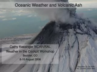
Oceanic Weather and Volcanic Ash. Cathy Kessinger NCAR/RAL Weather in the Cockpit Workshop Boulder, CO 8-10 August 2006. Augustine, 12 Jan 2006 M.L.Coombs, USGS-AVO. Oceanic Weather PDT.

Oceanic Weather and Volcanic Ash
E N D
Presentation Transcript
Oceanic Weather and Volcanic Ash Cathy Kessinger NCAR/RAL Weather in the Cockpit Workshop Boulder, CO 8-10 August 2006 Augustine, 12 Jan 2006 M.L.Coombs, USGS-AVO
Oceanic Weather PDT Primary mission: To improve aviation safety and efficiency within remote oceanic regions through the detection and forecasting of hazardous weather conditions. Oceanic Flight Information Regions • Long flight times of oceanic flights means pre-flight weather information becomes quite old • Weather into the cockpit is beneficial
Scientific Areas • Cockpit Display of Weather Products – Gary Blackburn • Volcanic Ash – Paul Herzegh • Improved Inflight Winds – Ted Tsui • Turbulence (CAT and CIT) – Bob Sharman • Convection Diagnosis and Nowcasting – Cathy Kessinger • Icing (FIP and CIP) – Marcia Politovich • Domains: • Pacific • North Pacific • Gulf of Mexico • North Atlantic - later
A little history… • NASA AvSP/AWRP Oceanic Convective Nowcasting Demonstration (OCND) Project • Purpose: demonstrate delivery of weather information in graphical form into the cockpit • ~1999-2001 • Workshops, user interactions and feedback to determine needs • AWRP Oceanic Weather PDT formed 2001 • OCND experience was basis
CTOP on Experimental ADDS Gulf of Mexico Pacific North Pacific • Experimental ADDS • Satellite page • http:weather.aero
Cockpit Display of CTOP • Collaboration with United Airlines and ARINC • Aircraft-relative display of cloud top altitude • Ascii format via thermal printer • ‘/’ = 30kft – 39kft and ‘C’ = >40kft • Pilot receives a “heads up” for approaching Wx. • Dispatcher also receives cockpit display • Common situational awareness • UAL testing on limited US-Aus flights • Favorable feedback, esp. unsolicited information Future Positions Cloud Top Height (CTOP) Current Position UAL 839
Web-based Pilot Feedback Form • Pilot feedback form…
OW Volcanic Ash Plans • Goal: Provide detection/warning/forecast capability of volcanic ash and gas plumes to aviation community • Requested by Users: • Five minute span from detectability to warning • Graphic of ash plume/cloud showing horizontal and vertical extent with frequent updates (inc. in the cockpit) • Current conditions & forecast (1 to 24h and beyond)
Volcanic Ash Advisory Center (VAAC) • Once eruption is reported (PIREP, Volcano Observatory, satellite), VAACs issue advisory to Met Watch Offices Meteorological Watch Offices issue VA SIGMET - AAWU, AWC, Guam, Hawaii - Dispatch, Airlines
Oceanic Weather Volcanic Ash Product • Build an expert system using: • Satellite remote detection – GOES, POES • A few NEXRADs near volcanoes • Seismic information • Dispersion models • Products: Detection and Forecast • Volcanic Ash Coordination Tool (VACT) is path to operations • AF PDT Development • Gives VAAC, AAWU, CWSU, Volcano Observatory common situational awareness to generate time-critical ash SIGMETS/forecasts • Anchorage first; Washington later
Getting a VA Product into the Cockpit… • After Advisory/SIGMET is ready for dissemination, then • Select specific aircraft that may intercept the ash cloud • Send graphical information directly to the aircraft via uplink • Human first, automation later • Within VACT • Do this within 5 minutes of receiving the advisory
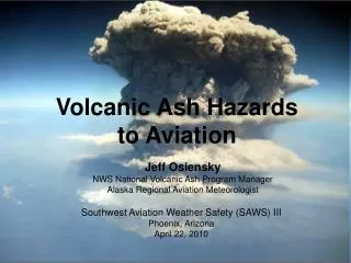
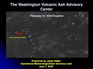
Soufriere Hills Eruption – 20 May 2006 • ~1100 eruption occurred • Stratospheric ash cloud • 1115 eruption cloud is visible on satellite • 1140 first Volcanic Ash Advisory (VAA) issued by Washington VAAC with few details • 1201 PIREP of ash to FL550, moving west • 1215 second VAA issued with details
Soufriere Hills Eruption, 20 May 2006, 1045-1445 Volcanic Ash Detection Visible Cloud Top Height Infrared
Washington VAAC Advisory Uplinked Product • Create graphical product to uplink to at-risk aircraft
Other Possible Uplinked Products for Oceanic Flights • Flight level winds from numerical model • Flight level temperature (fuel gel) from numerical model • Turbulence, both CAT and CIT sources • Hazardous convection and nowcasts • Icing