Download
1 / 11
110 likes | 211 Vues
Study the layering, mineralogy, and morphology of eroded craters for subsurface access to varied rock compositions. Analyze crater impact effects and transition between rock units.

E N D
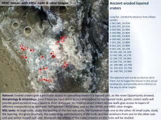
HRSC mosaic with HRSC nadir & color images Ancient eroded layered craters Long/lat : (ranked by distance from ellipse center) 1-341.06E, 24.05N 2-341.07E, 24.01N 3-340.96E, 23.98N 4-340.98E, 23.86N 5-340.94E, 23.86N 6-340.84E, 24.04N 7-341.20E, 23.88N 8-341.22E, 23.89N 9-341.14E, 24.12N 10-341.16E, 24.16N 11-341.18E, 24.17N 12-240.77E, 24.06N 13-340.75E, 24.06N 14 -340.98E, 23.76N 15- 341.01E, 23.75N 16- 340.79E, 23.98N The objective will not be to drive to all of them, but to target the closest to the actual landing site, and possibly some other(s) on the way to other targets. 11 10 9 13 12 6 1 2 16 3 8 7 4 5 14 15 Rational: Eroded craters give a particular access to subsurface layers in a layered unit, as the rover Opportunity showed. Morphology & mineralogy: Even if here we have direct access everywhere to the layered rocks, gentle craters walls will provide good access to many layers in short distances. We tried to select craters whose walls give access to layers of different compositions as seen with NIR spectral CRISM data, and on the HiRISE and HRSC color images. MSL tasks:At large scale, study the layering of the two sub-units, the transition from one to the other. At small scale, study the layering, the grain structure, the mineralogy and chemistry of the rocks and the variations from one to the other sub-unit and within in each sub-unit. Moreover the effects of the crater impacts on the rocks will be studied.
HiRISE mosaic with HRSC & HiRISE color images 1-341.06E, 24.05N 2-341.07E, 24.01N Close to the center of the ellipse #1 is smaller but excavates deeper layers. 1 km 1 Access to many layers 2
HiRISE mosaic with CRISM indices map (L.Saper) 1-341.06E, 24.05N 2-341.07E, 24.01N CRISM mineralmap Orange => Fe/Mg smectites Green => Fe2+ material Blue => Al-phyllosilicates Fe2+ material Fe/Mg smectites Al-phyllosilicates
HiRISE mosaic with HRSC & HiRISE color images 3-340.96E, 23.98N 300 m 3
4-340.98E, 23.86N 5-340.94E, 23.86N 500 m 4 5 HiRISE mosaic with HRSC & HiRISE color images
6-340.84E, 24.04N 12-240.77E, 24.06N 13-340.75E, 24.06N 1 km 13 12 6 HiRISE mosaic with HRSC & HiRISE color images
7-341.20E, 23.88N 8-341.22E, 23.89N 500 m 8 7 HiRISE mosaic with HRSC & HiRISE color images
9-341.14E, 24.12N 10-341.16E, 24.16N 11-341.18E, 24.17N HiRISE mosaic with HRSC & HiRISE color images 500 m 11 10 9
12 -340.77E, 24.05N 13- 340.75E, 24.06N HiRISE & CTX mosaic with HRSC color images 500 m 13 12
14 -340.98E, 23.76N 15- 341.01E, 23.75N The twocraters are locatedat a particular location at the top of a hill (~250 m local high) HiRISE mosaic with HiRISE color images 500 m 14 15
16- 340.79E, 23.98N 500 m 16 HiRISE mosaic