
SlideServe
Menu
Préférences
© SlideServe · v2026

Comprehensive Assessment of Global Environmental Services for Sustainable Development

dustin-hardy avatar
5 diapositives · 162 Views · Nov 12, 2014

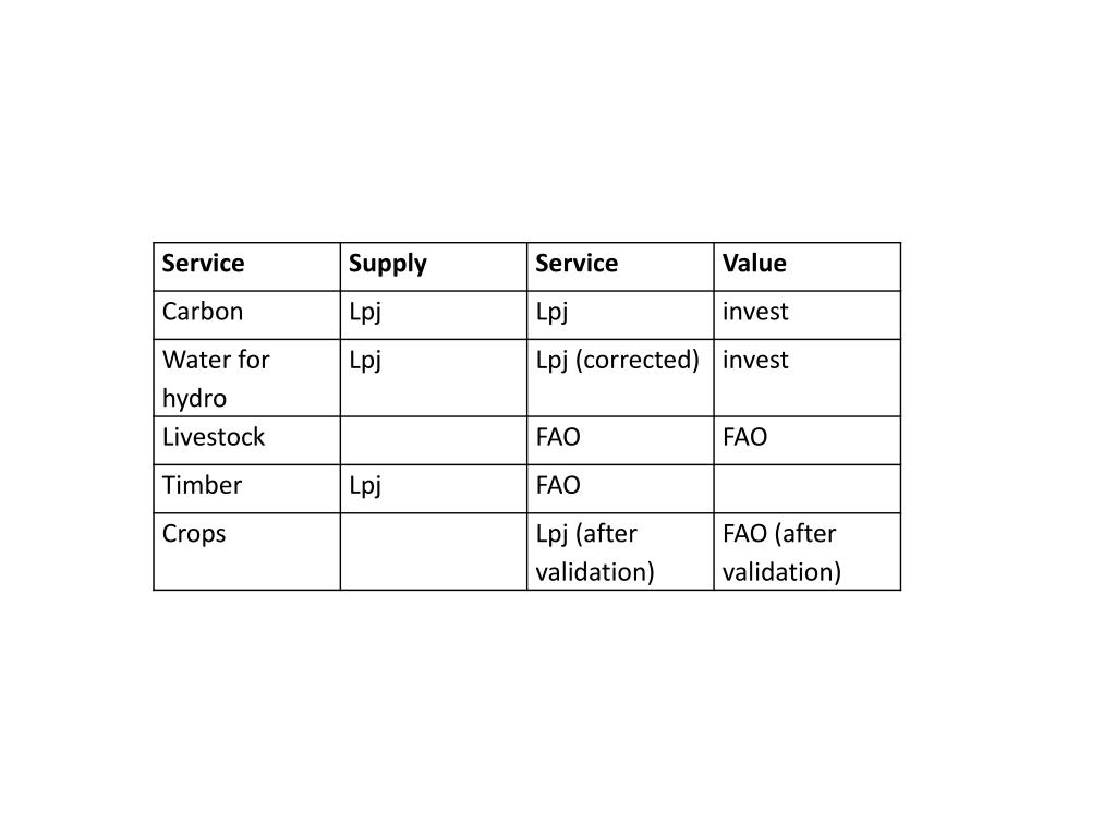
This project involves analyzing annual changes in global environmental services like carbon, crops, livestock, timber, and water. Using various metrics and models, we aim to assess the impact and value of these services over the past decade. The study will evaluate the relevance and significance of these systems on a global scale, focusing on key indicators such as supply, service, and value. The workplan includes data analysis, validation, and compiling results into figures for publication.
Comprehensive Assessment of Global Environmental Services for Sustainable Development - slide 1
01 / 5Comprehensive Assessment of Global Environmental Services for Sustainable Development
1 / 17

Télécharger la présentation

Comprehensive Assessment of Global Environmental Services for Sustainable Development
Une image / un lien ci-dessous est fourni (tel quel) pour télécharger la présentation

Politique de téléchargement : le contenu du site vous est fourni TEL QUEL pour votre information et votre usage personnel ; il ne peut être vendu, concédé sous licence ni partagé sur d’autres sites sans l’accord de son auteur.Le contenu vous est fourni TEL QUEL, pour votre information et votre usage personnel uniquement. Téléchargez la présentation en cliquant sur ce lien. Lors du téléchargement, si vous ne parvenez pas à télécharger une présentation, l’éditeur a peut-être supprimé le fichier de son serveur.Pendant le téléchargement, si vous ne parvenez pas à obtenir une présentation, le fichier a peut-être été supprimé par l’éditeur.

F I N

Plus de contenu associé

Transcription de la présentation

  1. Figures • Can show annual change: 3 panels, 1 for % change in global sum of supply relative to 1996; 1 for service; 1 for value as possible for full set of services • Can show different metrics, and they show different patterns: 3 panels for 3 continents, change over the decade for supply, service, value; 2 panels for globe, timber change over decade for service and value • Can show the system is relevant: 5(?) panels, carbon (service or value?) globally with change in our decade vs. past decade, indicating significance; crops (service or value?) globally with 1 yr % change relative to decade average (1996-2005); livestock protein vs. Human need; timber supply minus service, then compared to degradation; water (maybe not a map?)

  2. To do • Hydropower • Check price data (S) • Check on dams already incorporated into LPJ, find out how done and if matches with actual watersheds-use this if possible!! (P) • If can’t use LPJ with dams, Complete watersheds and validate (S) • Correct LPJ water yield estimates for urban consumptive use, combine that with ag extracted yield from LPJ (S, P) (we need both full yield and yield-irrigation) • Do usability check (S) • Crops • Correlate FAO and LPJ, if good, use FAO for maps (P) • If we use 13 crops, check IFPRI (S-Danny) • Do fitness for use and figure, can we pick up an extreme year somewhere on the globe?(P) • Livestock • Do usability analyses and figure (S-Danny and Bob) • Timber • Do usability analyses and figure (convert carbon to roundwood, compare to degradation rates). Can we detect unsustainable forestry at the national scale? (P) • Carbon • -Do usability analyses, compare annual change rates to LPJ change rates (P). Is our modeling giving us comparable signal to observations (same interannual variability)? • Run carbon valuation (S) • Compile all to figures (S-danny)

  3. Workplan • End of March – carbon yearly data to Stanford • May – conference call to check in on coordinated work • June – all supply info to Stanford for service/value calcs • Mid-August-all data to Danny • Sept – conference call to talk about completed figures, paper • Dec – submit paper

  4. Paper Outline • Introduction: • What’s needed for GEO BON, modeling and national stats as one component • For multiple services and metrics, see where in space, and how changes over time. (would we include table of metrics here for extensive list? Then say we’re did subset?) • One example of how this can be done, with one set of models; why this set of services? • Compare to what TEEB said was possible • Methods: • LPJml • FAO • InVEST • Any additional methods for determining utility • Results: • Figs 1 and 2 • Discussion • Fig 3 and implications and uses • Outstanding needs – major data issues (and revisit table saying further to go for more services?). Be clear on how this could be done and that it would fill needs for both GOE/GEOSS and CBD reporting