Multi-Modal Transit Routes Android App
This project utilizes Google Maps API for Android to display multi-modal transit routes between destinations and points of interest. The algorithm run on a server to find the least costly route.

Multi-Modal Transit Routes Android App
E N D
Presentation Transcript
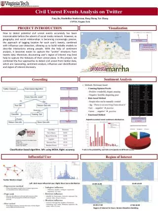
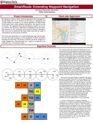
SmartRoute: Extending Waypoint Navigation Wei Wang, ParangSaraf, Kyle Schutt CS6604: Spatial Databases Client-side Application Project Introduction We elected to create a native Android application that leverages the Google Maps API v2 for Android as the basis for displaying and communicating the results of our custom algorithm for determining multi-modal transit routes between destinations and specific points of interest. The algorithm itself was developed in python to be run on a server. We decided to offload this computation from the client-side because of the complexity and resource-intensive calculation that must occur to determine the least costly route from an origin to a destination via some points of interest. The client side application is a simple single-page app that provides the user with auto-completion on the addresses or points of interest that they are searching. The points of interest can be as simple as a single category for a business type (e.g., a gym) or as specific as a restaurant (e.g., The Greene Turtle). Algorithm Overview The routing mechanism starts with identifying the most time efficient route using public transit between the given source and destination. Figure 5 explains the potential POI identification step. Once the initial route has been identified, all the transit stops are identified next. These stops can be identified based on the stored routes and bus stops from WMATA API. For each of these stops we have associated geo-coordinates. We use these geo-coordinates to query Google Places API to identify the potential POIs for each of the generic waypoints that has been entered by the user. An important point to notice here is that each of the generic waypoints will result in several potential POIs. For example, a user’s search for Starbucks will result in several Starbucks location that can be enroute. For each of these potential POIs there will be associated Google Places information like User ratings, visiting timings, cost ratings etc. Once each of the transit stops is identified, the system queries the Google Places API to identify potential POIs for both waypoint types in a 1-mile radius. Please note that we have taken the 1-mile as the maximum one way walking distance that a user might be willing to walk. For this radius-based search we get potential POIs that are then filtered based on cost and user ratings. As can be seen in the diagram there can be some transit stops that don’t have one qualifying waypoint type. For example, TS1 has only waypoint type of A present. Also there can be transit stops with none qualifying waypoint type. Once all the potential POIs have been identified, waypoint clustering mechanism is invoked which identifies the most suitable POIs to act as waypoints. In order to understand the waypoint clustering mechanism, it is helpful to visualize the potential POIs in a different way as shown in Figure 6. Here the nodes highlighted in gray correspond to the source, destination and the enroute transit stops. For each of these nodes, the potential POIs that can act as waypoints are shown in blue and red. The POIs to type A waypoint are shown in blue and the POIs of type B waypoints are shown in red. The goal is to identify a combination of Ai and Bj (where i<j) such that the route S – Ai – Bj – D leads to the most time efficient route. For cases where i>j, the route will become S – Bj – Ai – D.